
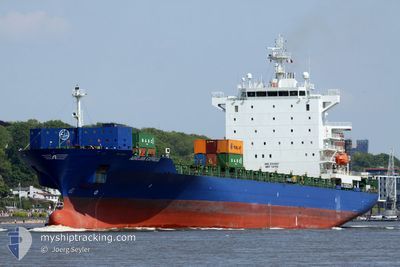
STANLEY A
Container Ship
Current Trip
| Time Travelled | 1 day |
|---|---|
| Remaining Time | 4 h, 7 mins |
| Distance Travelled | 266.58 nm |
| Remaining Distance | 77.26 nm |
| AVG Speed | 13.8 Knots |
| MAX Speed | 16.7 Knots |
| AVG Wind | 13.9 knots |
| MAX Wind | 24.5 knots |
| MIN Temp | 21.2°C / 70.16°F |
| MAX Temp | 26.1°C / 78.98°F |
| Draught | 12 m |
| Position Received | 3 h, 27 m ago |
Current Position
| Longitude | 57.28435° |
|---|---|
| Latitude | 25.15076° |
| Status | Under way using engine |
| Speed | 13.7 Knots |
| Course | 109.5° |
| Area | Gulf of Oman |
| Station | T-AIS |
| Position Received | 3 h, 27 m ago |
Info
Information
The current position of STANLEY A is in Gulf of Oman with coordinates 25.15076° / 57.28435° as reported on 2024-04-16 17:24 by AIS to our vessel tracker app. The vessel's current speed is 13.7 Knots and is heading at the port of FUJAIRAH. The estimated time of arrival as calculated by MyShipTracking vessel tracking app is 2024-04-17 00:59 LT
The vessel STANLEY A (IMO: 9303807, MMSI: 256547000) is a Container Ship that was built in 2006 ( 18 years old ). It's sailing under the flag of [MT] Malta.
In this page you can find informations about the vessels current position, last detected port calls, and current voyage information. If the vessels is not in coverage by AIS you will find the latest position.
The current position of STANLEY A is detected by our AIS receivers and we are not responsible for the reliability of the data. The last position was recorded while the vessel was in Coverage by the Ais receivers of our vessel tracking app.
The current draught of STANLEY A as reported by AIS is 12 meters
Weather
| Temperature | 22°C / 71.6°F |
|---|---|
| Wind Speed | 28 knots |
| Direction | 15° NNE |
| Pressure | 1006.2 hPa |
| Humidity | 85.8 % |
| Cloud Coverage | 100 % |
Featured Company
Last Port Calls
| Port | Arrival | Departure | Time In Port |
|---|---|---|---|
| 2024-04-13 11:09 | 2024-04-15 11:50 | 2 d | |
| 2024-03-29 06:19 | 2024-04-01 14:36 | 3 d | |
| 2024-03-20 07:34 | 2024-03-27 06:12 | 6 d | |
| 2024-02-15 10:09 | 2024-02-15 19:51 | 9 h | |
| 2024-02-12 19:46 | 2024-02-13 14:31 | 18 h | |
| 2024-02-08 19:49 | 2024-02-10 05:29 | 1 d |
Most Visited Ports (Last year)
| Port | Arrivals | |
|---|---|---|
| 7 | ||
| 7 | ||
| 6 | ||
| 5 | ||
| 4 | ||
| 4 |
Last Trips
| Origin | Departure | Destination | Arrival | Distance | |
|---|---|---|---|---|---|
| 2024-04-01 16:36 | 2024-04-13 15:09 | 4552.81 nm | |||
| 2024-03-27 08:12 | 2024-03-29 08:19 | 402.63 nm | |||
| 2024-02-16 01:21 | 2024-03-20 09:34 | 3890.67 nm | |||
| 2024-02-13 20:01 | 2024-02-15 15:39 | 440.26 nm | |||
| 2024-02-10 09:29 | 2024-02-13 01:16 | 957.80 nm | |||
| 2024-01-31 20:13 | 2024-02-08 23:49 | 3096.54 nm |
Events
| Time | Event | Details | Position / Dest | Info |
|---|---|---|---|---|
| 2024-04-16 17:28 | Status Changed | Default Under way using engine |
25.14697 / 57.29716
AEFJR
|
Speed: 13.7 kn Course: 109.5° |
| 2024-04-16 17:24 | OUT of Coverage |
25.15076 / 57.28435
Gulf of Oman
|
Speed: 13.7 kn Course: 109.5° |
|
| 2024-04-16 17:02 | Status Changed | Under way using engine Default |
25.17846 / 57.19705
AEFJR
|
Speed: 13.8 kn Course: 110° |
| 2024-04-16 16:59 | Status Changed | Default Under way using engine |
25.18257 / 57.18437
AEFJR
|
Speed: 13.9 kn Course: 110.2° |
| 2024-04-16 16:30 | Change Sea Area | Iranian part of the Gulf of Oman United Arab Emirates part of the Gulf of Oman |
25.22221 / 57.06711
Gulf of Oman
|
Speed: 14 kn Course: 109.5° |
| 2024-04-16 16:30 | Status Changed | Under way using engine Default |
25.22221 / 57.06711
AEFJR
|
Speed: 13 kn Course: 109° |
| 2024-04-16 16:26 | Status Changed | Default Under way using engine |
25.22667 / 57.05167
AEFJR
|
Speed: 13.7 kn Course: 105.9° |
| 2024-04-16 14:13 | Status Changed | Under way using engine At anchor |
25.25232 / 56.53761
AEFJR
|
Speed: 7.1 kn Course: 73.1° |
| 2024-04-16 14:08 | START Moving | 10.87 nm, North East of FUJAIRAH |
25.24797 / 56.53190
AEFJR
|
Speed: 3.5 kn Course: 26° |
| 2024-04-16 03:18 | Status Changed | At anchor Under way using engine |
25.24872 / 56.53543
AEFJR
|
Speed: 0.1 kn Course: 162° |