
YAMAL IRBIS
General Cargo
Current Trip
TANALAU (DUDINKA)
| Time Travelled | 25 days |
|---|---|
| Remaining Time | --- |
| Distance Travelled | 1760.07 nm |
| Remaining Distance | --- |
| AVG Speed | 9.1 Knop |
| MAX Speed | 12.9 Knop |
| AVG Wind | 9.3 knots |
| MAX Wind | 19 knots |
| MIN Temp | -30.6°C / -23.08°F |
| MAX Temp | -2.2°C / 28.04°F |
| Djupgående | 7.4 m |
| Position mottagen | 25 d sen |
Current Position
| Longitud | 33.08700° |
|---|---|
| Latitude | 69.05805° |
| Status | Under way using engine |
| Fart | 5.6 Knop |
| Kurs | 77° |
| Område | Barentsz Sea |
| Station | T-AIS |
| Position mottagen | 25 d sen |
Info
Information
The current position of YAMAL IRBIS is in Barentsz Sea with coordinates 69.05805° / 33.08700° as reported on 2024-03-25 03:25 by AIS to our vessel tracker app. The vessel's current speed is 5.6 Knop
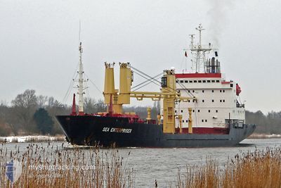
The vessel YAMAL IRBIS (IMO: 8502092, MMSI: 273375620) is a General Cargo that was built in 1998 ( 26 År gammal ). It's sailing under the flag of [RU] Russia.
In this page you can find informations about the vessels current position, last detected port calls, and current voyage information. If the vessels is not in coverage by AIS you will find the latest position.
The current position of YAMAL IRBIS is detected by our AIS receivers and we are not responsible for the reliability of the data. The last position was recorded while the vessel was in Coverage by the Ais receivers of our vessel tracking app.
The current draught of YAMAL IRBIS as reported by AIS is 7.4 meters
Weather
| Temperature | -17.7°C / 0.14°F |
|---|---|
| Wind Speed | 19 knots |
| Direction | 26° NNE |
| Pressure | 1022.9 hPa |
| Humidity | 90.4 % |
| Cloud Coverage | 100 % |
Featured Company
Most Visited Ports (Last year)
| Port | Arrivals | |
|---|---|---|
| 7 | ||
| 6 | ||
| 4 | ||
| 2 | ||
| 1 | ||
| 1 |
Events
| Tid | Event | Detaljer | Position / Dest | Information |
|---|---|---|---|---|
| 2024-04-15 22:33 | STOPPAR förflyttning | 20.74 nm, South of DIKSON |
73.16296 / 80.41098
TANALAU (DUDINKA)
|
Fart: Kurs: 23° |
| 2024-04-15 22:22 | STARTAR förflyttning | 20.77 nm, South of DIKSON |
73.16246 / 80.41005
TANALAU (DUDINKA)
|
Fart: 4.6 kn Kurs: 30° |
| 2024-04-15 19:55 | STOPPAR förflyttning | 20.95 nm, South of DIKSON |
73.15977 / 80.40138
TANALAU (DUDINKA)
|
Fart: Kurs: 39° |
| 2024-04-15 12:45 | STARTAR förflyttning |
72.30153 / 80.58577
TANALAU (DUDINKA)
|
Fart: 9.1 kn Kurs: 325° |
|
| 2024-04-15 12:26 | STOPPAR förflyttning |
72.29363 / 80.60998
TANALAU (DUDINKA)
|
Fart: Kurs: 320° |
|
| 2024-04-14 20:28 | STARTAR förflyttning |
70.76378 / 83.50028
TANALAU (DUDINKA)
|
Fart: 7.8 kn Kurs: 352° |
|
| 2024-04-10 08:34 | STOPPAR förflyttning |
70.73666 / 83.53333
TANALAU (DUDINKA)
|
Fart: Kurs: -1° |
|
| 2024-04-10 08:16 | STARTAR förflyttning |
70.75500 / 83.50333
TANALAU (DUDINKA)
|
Fart: 6 kn Kurs: 173° |
|
| 2024-04-10 05:42 | STOPPAR förflyttning |
70.75857 / 83.50267
TANALAU (DUDINKA)
|
Fart: Kurs: 167° |