
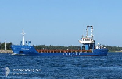
WILSON RHINE
General Cargo
Current Trip
| Time Travelled | 4 days |
|---|---|
| Remaining Time | --- |
| Distance Travelled | 648.39 nm |
| Remaining Distance | --- |
| AVG Speed | 8.4 Knop |
| MAX Speed | 11.7 Knop |
| AVG Wind | 10.4 knots |
| MAX Wind | 27 knots |
| MIN Temp | 2.4°C / 36.32°F |
| MAX Temp | 6.6°C / 43.88°F |
| Djupgående | 4.5 m |
| Position mottagen | 17 h, 0 m sen |
Current Position
| Longitud | 5.18494° |
|---|---|
| Latitude | 57.26245° |
| Status | Under way using engine |
| Fart | 8.7 Knop |
| Kurs | 217.1° |
| Område | North Sea |
| Station | T-AIS |
| Position mottagen | 17 h, 0 m sen |
Info
Information
The current position of WILSON RHINE is in North Sea with coordinates 57.26245° / 5.18494° as reported on 2024-04-23 06:43 by AIS to our vessel tracker app. The vessel's current speed is 8.7 Knop and is heading at the port of GUNNESS. The estimated time of arrival as calculated by MyShipTracking vessel tracking app is 2024-04-24 18:30 LT
The vessel WILSON RHINE (IMO: 9168116, MMSI: 314260000) is a General Cargo that was built in 1998 ( 26 År gammal ). It's sailing under the flag of [BB] Barbados.
In this page you can find informations about the vessels current position, last detected port calls, and current voyage information. If the vessels is not in coverage by AIS you will find the latest position.
The current position of WILSON RHINE is detected by our AIS receivers and we are not responsible for the reliability of the data. The last position was recorded while the vessel was in Coverage by the Ais receivers of our vessel tracking app.
The current draught of WILSON RHINE as reported by AIS is 4.5 meters
Weather
| Temperature | 6°C / 42.8°F |
|---|---|
| Wind Speed | 27 knots |
| Direction | 345° NNW |
| Pressure | 1015 hPa |
| Humidity | 69.5 % |
| Cloud Coverage | 100 % |
Featured Company
Last Port Calls
| Port | Arrival | Departure | Time In Port |
|---|---|---|---|
| 2024-04-18 13:54 | 2024-04-19 19:34 | 1 d | |
| 2024-04-13 17:15 | 2024-04-15 12:47 | 1 d | |
| 2024-04-12 16:51 | 2024-04-13 08:58 | 16 h | |
| 2024-04-09 05:05 | 2024-04-10 17:24 | 1 d | |
| 2024-04-07 22:19 | 2024-04-08 11:36 | 13 h | |
| 2024-04-01 14:19 | 2024-04-02 11:11 | 20 h | |
| 2024-03-25 01:19 | 2024-03-25 14:51 | 13 h | |
| 2024-03-22 21:05 | 2024-03-23 10:49 | 13 h | |
| 2024-03-17 11:42 | 2024-03-19 04:32 | 1 d | |
| 2024-03-12 18:02 | 2024-03-13 08:54 | 14 h |
Last Trips
| Origin | Departure | Destination | Arrival | Distance | |
|---|---|---|---|---|---|
| 2024-04-15 14:47 | 2024-04-18 15:54 | 570.89 nm | |||
| 2024-04-13 10:58 | 2024-04-13 19:15 | 87.30 nm | |||
| 2024-04-10 18:24 | 2024-04-12 18:51 | 469.56 nm | |||
| 2024-04-08 13:36 | 2024-04-09 06:05 | 105.73 nm | |||
| 2024-04-02 13:11 | 2024-04-08 00:19 | 539.50 nm | |||
| 2024-03-25 15:51 | 2024-04-01 16:19 | 124.22 nm | |||
| 2024-03-23 11:49 | 2024-03-25 02:19 | 302.27 nm | |||
| 2024-03-19 05:32 | 2024-03-22 22:05 | 619.86 nm | |||
| 2024-03-13 09:54 | 2024-03-17 12:42 | 610.50 nm | |||
| 2024-03-11 18:37 | 2024-03-12 19:02 | 265.18 nm |
Events
| Tid | Event | Detaljer | Position / Dest | Information |
|---|---|---|---|---|
| 2024-04-23 06:43 | UTANFÖR täckningsområde |
57.26245 / 5.18494
North Sea
GUNNESS
|
Fart: 8.7 kn Kurs: 217.1° |
|
| 2024-04-22 23:04 | Destination ändrad | GUNNESS GUNNES |
58.25822 / 6.18285
GUNNESS
|
Fart: 9.2 kn Kurs: 212.9° |
| 2024-04-22 22:09 | STARTAR förflyttning | 2.82 nm, East of REKEFJORD |
58.32211 / 6.34723
GUNNES
|
Fart: 3.9 kn Kurs: 229° |
| 2024-04-22 21:59 | Status ändrad | Under way using engine Default |
58.32407 / 6.35173
GUNNES
|
Fart: Kurs: 21° |
| 2024-04-22 21:30 | Status ändrad | Default Moored |
58.32404 / 6.35161
GUNNES
|
Fart: 0.1 kn Kurs: 21° |
| 2024-04-22 21:24 | Status ändrad | Moored Default |
58.32408 / 6.35156
GUNNES
|
Fart: Kurs: 21° |
| 2024-04-22 21:24 | I täckningsområde |
58.32408 / 6.35156
North Sea
GUNNES
|
Fart: 0.1 kn Kurs: 184.5° |
|
| 2024-04-22 19:54 | UTANFÖR täckningsområde |
58.32401 / 6.35166
North Sea
GUNNES
|
Fart: Kurs: 54.3° |
|
| 2024-04-22 17:44 | Djupgående ändrat | 4.5 2.9 |
58.32390 / 6.35153
GUNNES
|
Fart: 0.1 kn Kurs: 20° |
| 2024-04-22 17:44 | Destination ändrad | GUNNES NOJSS |
58.32390 / 6.35153
GUNNES
|
Fart: 0.1 kn Kurs: 20° |