
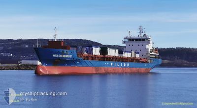
WILSON NEWPORT
General Cargo
Current Trip
| Trip Time | 7 days |
|---|---|
| Trip Distance | 1585.35 nm |
| AVG Speed | 10.6 Knop |
| MAX Speed | 13.7 Knop |
| Djupgående | 7.2 m |
| AVG Wind | 12.1 knots |
| MAX Wind | 26.6 knots |
| MIN Temp | -16.3°C / 2.66°F |
| MAX Temp | 5.7°C / 42.26°F |
| Position mottagen | 1 m sen |
Current Position
| Longitud | 14.11337° |
|---|---|
| Latitude | 66.30610° |
| Status | Under way using engine |
| Fart | |
| Kurs | 72° |
| Område | Norwegian Sea |
| Station | T-AIS |
| Position mottagen | 1 m sen |
Info
Information
The current position of WILSON NEWPORT is in Norwegian Sea with coordinates 66.30610° / 14.11337° as reported on 2024-04-24 20:21 by AIS to our vessel tracker app. The vessel's current speed is 0 Knop and is currently inside the port of MOIRANA.
The vessel WILSON NEWPORT (IMO: 9430985, MMSI: 259013000) is a General Cargo that was built in 2011 ( 13 År gammal ). It's sailing under the flag of [NO] Norway.
In this page you can find informations about the vessels current position, last detected port calls, and current voyage information. If the vessels is not in coverage by AIS you will find the latest position.
The current position of WILSON NEWPORT is detected by our AIS receivers and we are not responsible for the reliability of the data. The last position was recorded while the vessel was in Coverage by the Ais receivers of our vessel tracking app.
The current draught of WILSON NEWPORT as reported by AIS is 7.2 meters
Weather
| Temperature | -1°C / 30.2°F |
|---|---|
| Wind Speed | 3 knots |
| Direction | 115° ESE |
| Pressure | 1009 hPa |
| Humidity | 86.1 % |
| Cloud Coverage | 98 % |
Featured Company
Last Port Calls
| Port | Arrival | Departure | Time In Port |
|---|---|---|---|
| 2024-04-23 20:42 | |||
| 2024-04-13 12:00 | 2024-04-16 13:57 | 3 d | |
| 2024-04-02 08:12 | 2024-04-03 12:34 | 1 d | |
| 2024-03-23 22:29 | 2024-03-25 01:34 | 1 d | |
| 2024-03-19 18:38 | 2024-03-21 16:50 | 1 d | |
| 2024-03-16 04:44 | 2024-03-16 17:46 | 13 h | |
| 2024-03-15 01:35 | 2024-03-16 04:11 | 1 d | |
| 2024-03-14 11:48 | 2024-03-15 01:12 | 13 h | |
| 2024-03-11 14:13 | 2024-03-14 04:50 | 2 d | |
| 2024-03-07 08:28 | 2024-03-09 01:52 | 1 d |
Last Trips
| Origin | Departure | Destination | Arrival | Distance | |
|---|---|---|---|---|---|
| 2024-04-16 15:57 | 2024-04-23 22:42 | 1585.35 nm | |||
| 2024-04-03 12:34 | 2024-04-13 14:00 | 2313.51 nm | |||
| 2024-03-25 02:34 | 2024-04-02 08:12 | 1854.61 nm | |||
| 2024-03-21 16:50 | 2024-03-23 23:29 | 656.98 nm | |||
| 2024-03-16 18:46 | 2024-03-19 18:38 | 709.25 nm | |||
| 2024-03-16 05:11 | 2024-03-16 05:44 | 2.21 nm | |||
| 2024-03-15 02:12 | 2024-03-15 02:35 | 1.49 nm | |||
| 2024-03-14 05:50 | 2024-03-14 12:48 | 66.51 nm | |||
| 2024-03-09 02:52 | 2024-03-11 15:13 | 516.25 nm | |||
| 2024-03-04 23:32 | 2024-03-07 09:28 | 589.34 nm |
Events
| Tid | Event | Detaljer | Position / Dest | Information |
|---|---|---|---|---|
| 2024-04-23 20:54 | STOPPAR förflyttning |
66.30605 / 14.11078
[NO] MOIRANA
|
Fart: 0.1 kn Kurs: 79° |
|
| 2024-04-23 20:42 | ANLÄNDER HAMN |
|
66.30478 / 14.09865
[NO] MOIRANA
|
Fart: 4.4 kn Kurs: 67° |
| 2024-04-23 17:33 | STARTAR förflyttning | 2.12 nm, North East of NESNA |
66.23098 / 13.05613
MO I RANA
|
Fart: 4 kn Kurs: 236° |
| 2024-04-23 17:27 | Status ändrad | Under way using engine At anchor |
66.23053 / 13.06303
MO I RANA
|
Fart: 0.1 kn Kurs: 1° |
| 2024-04-23 07:30 | ETA ändrat | 2024/04/23 20:00 2024/04/23 03:00 |
66.23093 / 13.05863
MO I RANA
|
Fart: Kurs: 83° |
| 2024-04-23 04:04 | Status ändrad | At anchor Default |
66.23108 / 13.05872
MO I RANA
|
Fart: Kurs: 90° |
| 2024-04-23 03:58 | Status ändrad | Default At anchor |
66.23120 / 13.05908
MO I RANA
|
Fart: Kurs: 95° |
| 2024-04-23 02:28 | Status ändrad | At anchor Under way using engine |
66.23165 / 13.05920
MO I RANA
|
Fart: 0.2 kn Kurs: 101° |
| 2024-04-23 02:14 | STOPPAR förflyttning | 2.18 nm, North East of NESNA |
66.23087 / 13.06137
MO I RANA
|
Fart: 0.3 kn Kurs: 84° |
| 2024-04-21 00:18 | Byter havsområde | Norwegian part of the Norwegian Sea Norwegian part of the Barentsz Sea |
71.27580 / 25.52088
Norwegian Sea
MO I RANA
|
Fart: 10.5 kn Kurs: 270° |