
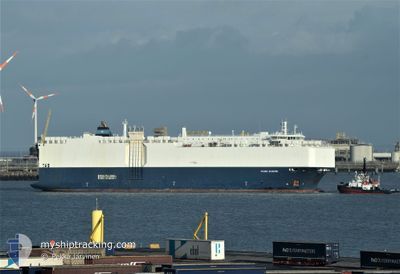
VIKING DIAMOND
Vehicles Carrier
Current Trip
| Time Travelled | 12 days |
|---|---|
| Remaining Time | 1 day |
| Distance Travelled | 3873.48 nm |
| Remaining Distance | 556.46 nm |
| AVG Speed | 14.2 Knop |
| MAX Speed | 18.3 Knop |
| AVG Wind | 6.6 knots |
| MAX Wind | 18 knots |
| MIN Temp | 23.9°C / 75.02°F |
| MAX Temp | 30.1°C / 86.18°F |
| Djupgående | 7.2 m |
| Position mottagen | 16 h, 21 m sen |
Current Position
| Longitud | 104.44395° |
|---|---|
| Latitude | 1.37878° |
| Status | Under way using engine |
| Fart | 13.6 Knop |
| Kurs | 48.6° |
| Område | South China Sea |
| Station | T-AIS |
| Position mottagen | 16 h, 21 m sen |
Info
Information
The current position of VIKING DIAMOND is in South China Sea with coordinates 1.37878° / 104.44395° as reported on 2024-04-19 00:54 by AIS to our vessel tracker app. The vessel's current speed is 13.6 Knop and is heading at the port of LAEM CHABANG. The estimated time of arrival as calculated by MyShipTracking vessel tracking app is 2024-04-21 09:52 LT
The vessel VIKING DIAMOND (IMO: 9481075, MMSI: 538009729) is a Vehicles Carrier that was built in 2011 ( 13 År gammal ). It's sailing under the flag of [MH] Marshall Is.
In this page you can find informations about the vessels current position, last detected port calls, and current voyage information. If the vessels is not in coverage by AIS you will find the latest position.
The current position of VIKING DIAMOND is detected by our AIS receivers and we are not responsible for the reliability of the data. The last position was recorded while the vessel was in Coverage by the Ais receivers of our vessel tracking app.
The current draught of VIKING DIAMOND as reported by AIS is 7.2 meters
Weather
| Temperature | 29.5°C / 85.1°F |
|---|---|
| Wind Speed | 6 knots |
| Direction | 93° E |
| Pressure | 1007.7 hPa |
| Humidity | 75.4 % |
| Cloud Coverage | 91 % |
Featured Company
Last Port Calls
| Port | Arrival | Departure | Time In Port |
|---|---|---|---|
| 2024-04-01 15:21 | 2024-04-07 00:39 | 5 d | |
| 2024-03-21 18:56 | 2024-03-23 01:12 | 1 d | |
| 2024-03-20 22:50 | 2024-03-21 15:26 | 16 h | |
| 2024-03-19 14:00 | 2024-03-20 00:00 | 10 h | |
| 2024-03-09 09:34 | 2024-03-10 04:57 | 19 h | |
| 2024-03-02 08:20 | 2024-03-02 19:54 | 11 h | |
| 2024-02-26 09:43 | 2024-02-28 12:54 | 2 d |
Last Trips
| Origin | Departure | Destination | Arrival | Distance | |
|---|---|---|---|---|---|
| 2024-03-23 05:12 | 2024-04-01 18:21 | 365.00 nm | |||
| 2024-03-21 19:26 | 2024-03-21 22:56 | 42.71 nm | |||
| 2024-03-20 04:00 | 2024-03-21 02:50 | 297.63 nm | |||
| 2024-03-10 12:57 | 2024-03-19 18:00 | 3307.33 nm | |||
| 2024-03-03 03:54 | 2024-03-09 17:34 | 2236.51 nm | |||
| 2024-02-28 21:54 | 2024-03-02 16:20 | 905.69 nm | |||
| 2024-01-30 13:19 | 2024-02-26 18:43 | 8662.50 nm |
Events
| Tid | Event | Detaljer | Position / Dest | Information |
|---|---|---|---|---|
| 2024-04-19 00:54 | UTANFÖR täckningsområde |
1.37878 / 104.44395
South China Sea
TH LCH
|
Fart: 13.6 kn Kurs: 48.6° |
|
| 2024-04-19 00:28 | Byter havsområde | Malaysian part of the South China Sea Malaysian part of the Singapore Strait |
1.32143 / 104.36633
South China Sea
TH LCH
|
Fart: 13.4 kn Kurs: 43.9° |
| 2024-04-18 23:32 | Byter havsområde | Malaysian part of the Singapore Strait Indonesian part of the Singapore Strait |
1.25947 / 104.17536
Singapore Strait
TH LCH
|
Fart: 13.1 kn Kurs: 77.5° |
| 2024-04-18 20:48 | ETA ändrat | 2024/04/21 13:00 2024/04/22 10:00 |
1.06223 / 103.68816
TH LCH
|
Fart: 9.1 kn Kurs: 55.9° |
| 2024-04-18 19:13 | Byter havsområde | Indonesian part of the Singapore Strait Indonesian part of the Malacca Strait |
1.16205 / 103.45111
Singapore Strait
TH LCH
|
Fart: 13 kn Kurs: 121° |
| 2024-04-18 19:02 | Upptäckt i hav | Indonesian part of the Malacca Strait |
1.18161 / 103.41689
Malacca Strait
TH LCH
|
Fart: 11.8 kn Kurs: 120.3° |
| 2024-04-18 19:02 | I täckningsområde |
1.18161 / 103.41689
Malacca Strait
TH LCH
|
Fart: 11.8 kn Kurs: 120.3° |
|
| 2024-04-13 10:48 | Status ändrad | Default Under way using engine |
7.08381 / 77.61986
TH LCH
|
Fart: 14.1 kn Kurs: 120.9° |
| 2024-04-13 10:44 | UTANFÖR täckningsområde |
7.09111 / 77.60806
Laccadive Sea
TH LCH
|
Fart: 14.1 kn Kurs: 120.9° |
|
| 2024-04-13 10:38 | Status ändrad | Under way using engine Default |
7.10321 / 77.58808
TH LCH
|
Fart: 14 kn Kurs: 120° |