
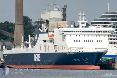
VICTORIA SEAWAYS
Ro-Ro/Passenger Ship
Current Trip
| Time Travelled | 17 h, 12 mins |
|---|---|
| Remaining Time | --- |
| Distance Travelled | 341.91 nm |
| Remaining Distance | --- |
| AVG Speed | 19.6 Knop |
| MAX Speed | 20.9 Knop |
| AVG Wind | 11.5 knots |
| MAX Wind | 14.3 knots |
| MIN Temp | 1.6°C / 34.88°F |
| MAX Temp | 6.2°C / 43.16°F |
| Djupgående | 6.3 m |
| Position mottagen | 1 m sen |
Current Position
| Longitud | 11.56220° |
|---|---|
| Latitude | 54.50494° |
| Status | Under way using engine |
| Fart | 19.6 Knop |
| Kurs | 298.1° |
| Område | Baltic Sea |
| Station | T-AIS |
| Position mottagen | 1 m sen |
Info
Information
The current position of VICTORIA SEAWAYS is in Baltic Sea with coordinates 54.50494° / 11.56220° as reported on 2024-04-24 11:54 by AIS to our vessel tracker app. The vessel's current speed is 19.6 Knop
The vessel VICTORIA SEAWAYS (IMO: 9350721, MMSI: 277408000) is a Ro-Ro/Passenger Ship that was built in 2009 ( 15 År gammal ). It's sailing under the flag of [LT] Lithuania.
In this page you can find informations about the vessels current position, last detected port calls, and current voyage information. If the vessels is not in coverage by AIS you will find the latest position.
The current position of VICTORIA SEAWAYS is detected by our AIS receivers and we are not responsible for the reliability of the data. The last position was recorded while the vessel was in Coverage by the Ais receivers of our vessel tracking app.
The current draught of VICTORIA SEAWAYS as reported by AIS is 6.3 meters
Weather
| Temperature | 4.7°C / 40.46°F |
|---|---|
| Wind Speed | 11 knots |
| Direction | 139° SE |
| Pressure | 1006.2 hPa |
| Humidity | 88.1 % |
| Cloud Coverage | 100 % |
Featured Company
Last Port Calls
| Port | Arrival | Departure | Time In Port |
|---|---|---|---|
| 2024-04-23 14:20 | 2024-04-23 18:43 | 4 h | |
| 2024-04-21 17:30 | 2024-04-22 17:53 | 1 d | |
| 2024-04-20 16:21 | 2024-04-20 20:32 | 4 h | |
| 2024-04-19 15:57 | 2024-04-19 21:04 | 5 h | |
| 2024-04-18 15:17 | 2024-04-18 20:19 | 5 h | |
| 2024-04-17 14:57 | 2024-04-17 19:29 | 4 h | |
| 2024-04-16 14:18 | 2024-04-16 19:11 | 4 h | |
| 2024-04-14 17:30 | 2024-04-15 17:42 | 1 d | |
| 2024-04-13 16:22 | 2024-04-13 21:01 | 4 h | |
| 2024-04-12 16:03 | 2024-04-12 20:37 | 4 h |
Last Trips
| Origin | Departure | Destination | Arrival | Distance | |
|---|---|---|---|---|---|
| 2024-04-22 19:53 | 2024-04-23 17:20 | 398.32 nm | |||
| 2024-04-20 23:32 | 2024-04-21 19:30 | 401.61 nm | |||
| 2024-04-19 23:04 | 2024-04-20 19:21 | 397.69 nm | |||
| 2024-04-18 23:19 | 2024-04-19 17:57 | 400.41 nm | |||
| 2024-04-17 21:29 | 2024-04-18 18:17 | 398.03 nm | |||
| 2024-04-16 22:11 | 2024-04-17 16:57 | 399.78 nm | |||
| 2024-04-15 19:42 | 2024-04-16 17:18 | 397.98 nm | |||
| 2024-04-14 00:01 | 2024-04-14 19:30 | 399.67 nm | |||
| 2024-04-12 22:37 | 2024-04-13 19:22 | 398.59 nm | |||
| 2024-04-11 23:27 | 2024-04-12 18:03 | 399.75 nm |
Events
| Tid | Event | Detaljer | Position / Dest | Information |
|---|---|---|---|---|
| 2024-04-24 10:50 | Byter havsområde | Danish part of the Baltic Sea German part of the Baltic Sea |
54.44632 / 12.12757
Baltic Sea
LTKLJ-DEKEL-LTKLJ
|
Fart: 19.4 kn Kurs: 269.7° |
| 2024-04-24 10:38 | Byter havsområde | German part of the Baltic Sea Danish part of the Baltic Sea |
54.48111 / 12.20421
Baltic Sea
LTKLJ-DEKEL-LTKLJ
|
Fart: 19.4 kn Kurs: 199.6° |
| 2024-04-24 09:59 | Byter havsområde | Danish part of the Baltic Sea German part of the Baltic Sea |
54.65371 / 12.39270
Baltic Sea
LTKLJ-DEKEL-LTKLJ
|
Fart: 19.3 kn Kurs: 236.7° |
| 2024-04-24 09:38 | Byter havsområde | German part of the Baltic Sea Danish part of the Baltic Sea |
54.71521 / 12.55578
Baltic Sea
LTKLJ-DEKEL-LTKLJ
|
Fart: 19.2 kn Kurs: 236.7° |
| 2024-04-24 09:08 | Byter havsområde | Danish part of the Baltic Sea German part of the Baltic Sea |
54.78385 / 12.80222
Baltic Sea
LTKLJ-DEKEL-LTKLJ
|
Fart: 19.7 kn Kurs: 264.8° |
| 2024-04-24 08:02 | Status ändrad | Under way using engine Default |
54.84370 / 13.43691
LTKLJ-DEKEL-LTKLJ
|
Fart: 20.5 kn Kurs: 254° |
| 2024-04-24 07:56 | Status ändrad | Default Under way using engine |
54.85243 / 13.49319
LTKLJ-DEKEL-LTKLJ
|
Fart: 20.2 kn Kurs: 254.5° |
| 2024-04-24 06:59 | Byter havsområde | German part of the Baltic Sea Danish part of the Kattegat |
54.90125 / 14.05094
Baltic Sea
LTKLJ-DEKEL-LTKLJ
|
Fart: 20.2 kn Kurs: 264.8° |
| 2024-04-24 03:53 | Byter havsområde | Danish part of the Kattegat Polish part of the Baltic Sea |
55.05035 / 15.80928
Kattegat
LTKLJ-DEKEL-LTKLJ
|
Fart: 20.6 kn Kurs: 256.5° |
| 2024-04-24 02:55 | Byter havsområde | Polish part of the Baltic Sea Lithuanian part of the Baltic Sea |
55.12384 / 16.37045
Baltic Sea
LTKLJ-DEKEL-LTKLJ
|
Fart: 20.6 kn Kurs: 257.2° |