
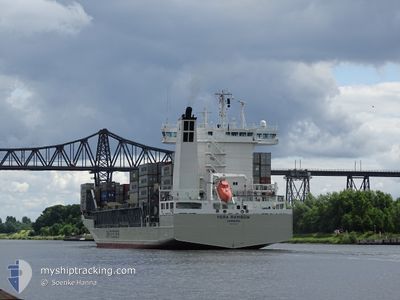
VERA RAMBOW
Container Ship
Current Trip
| Time Travelled | 15 h, 44 mins |
|---|---|
| Remaining Time | --- |
| Distance Travelled | 98.51 nm |
| Remaining Distance | --- |
| AVG Speed | 15 Knop |
| MAX Speed | 19.1 Knop |
| AVG Wind | 18.7 knots |
| MAX Wind | 23.9 knots |
| MIN Temp | 2°C / 35.6°F |
| MAX Temp | 2.7°C / 36.86°F |
| Djupgående | 9.1 m |
| Position mottagen | 9 h, 7 m sen |
Current Position
| Longitud | 22.03582° |
|---|---|
| Latitude | 59.31860° |
| Status | Under way using engine |
| Fart | 19.1 Knop |
| Kurs | 237.1° |
| Område | Baltic Sea |
| Station | T-AIS |
| Position mottagen | 9 h, 7 m sen |
Info
Information
The current position of VERA RAMBOW is in Baltic Sea with coordinates 59.31860° / 22.03582° as reported on 2024-04-25 08:24 by AIS to our vessel tracker app. The vessel's current speed is 19.1 Knop
The vessel VERA RAMBOW (IMO: 9432220, MMSI: 218627000) is a Container Ship that was built in 2008 ( 16 År gammal ). It's sailing under the flag of [DE] Germany.
In this page you can find informations about the vessels current position, last detected port calls, and current voyage information. If the vessels is not in coverage by AIS you will find the latest position.
The current position of VERA RAMBOW is detected by our AIS receivers and we are not responsible for the reliability of the data. The last position was recorded while the vessel was in Coverage by the Ais receivers of our vessel tracking app.
The current draught of VERA RAMBOW as reported by AIS is 9.1 meters
Weather
| Temperature | 3.2°C / 37.76°F |
|---|---|
| Wind Speed | 10 knots |
| Direction | 290° WNW |
| Pressure | 1004.4 hPa |
| Humidity | 95.9 % |
| Cloud Coverage | 100 % |
Featured Company
Last Port Calls
| Port | Arrival | Departure | Time In Port |
|---|---|---|---|
| 2024-04-24 20:50 | 2024-04-25 01:48 | 4 h | |
| 2024-04-24 04:04 | 2024-04-24 17:59 | 13 h | |
| 2024-04-19 08:27 | 2024-04-20 04:39 | 20 h | |
| 2024-04-16 09:22 | 2024-04-17 16:58 | 1 d | |
| 2024-04-15 11:04 | 2024-04-16 02:11 | 15 h | |
| 2024-04-14 07:31 | 2024-04-14 08:19 | 48 m | |
| 2024-04-12 06:29 | 2024-04-13 03:16 | 20 h | |
| 2024-04-11 14:16 | 2024-04-11 19:52 | 5 h | |
| 2024-04-10 01:54 | 2024-04-10 15:32 | 13 h | |
| 2024-04-08 03:16 | 2024-04-08 17:45 | 14 h |
Last Trips
| Origin | Departure | Destination | Arrival | Distance | |
|---|---|---|---|---|---|
| 2024-04-24 20:59 | 2024-04-24 23:50 | 45.43 nm | |||
| 2024-04-20 06:39 | 2024-04-24 07:04 | 584.49 nm | |||
| 2024-04-17 18:58 | 2024-04-19 10:27 | 444.49 nm | |||
| 2024-04-16 04:11 | 2024-04-16 11:22 | 110.10 nm | |||
| 2024-04-14 10:19 | 2024-04-15 13:04 | 135.28 nm | |||
| 2024-04-13 05:16 | 2024-04-14 09:31 | 362.36 nm | |||
| 2024-04-11 22:52 | 2024-04-12 08:29 | 160.34 nm | |||
| 2024-04-10 18:32 | 2024-04-11 17:16 | 350.01 nm | |||
| 2024-04-08 20:45 | 2024-04-10 04:54 | 157.31 nm | |||
| 2024-04-03 12:49 | 2024-04-08 06:16 | 716.18 nm |
Events
| Tid | Event | Detaljer | Position / Dest | Information |
|---|---|---|---|---|
| 2024-04-25 08:24 | UTANFÖR täckningsområde |
59.31860 / 22.03582
Baltic Sea
PLGDN
|
Fart: 19.1 kn Kurs: 237.1° |
|
| 2024-04-25 08:24 | Upptäckt i hav | Estonian part of the Baltic Sea |
59.31860 / 22.03582
Baltic Sea
PLGDN
|
Fart: 19.1 kn Kurs: 237.1° |
| 2024-04-25 08:24 | I täckningsområde |
59.31860 / 22.03582
Baltic Sea
PLGDN
|
Fart: 19.1 kn Kurs: 237.1° |
|
| 2024-04-25 07:05 | UTANFÖR täckningsområde |
59.50491 / 22.57287
Baltic Sea
PLGDN
|
Fart: 14.7 kn Kurs: 254.1° |
|
| 2024-04-25 05:59 | Byter havsområde | Finnish part of the Baltic Sea Finnish part of the Gulf of Finland |
59.57322 / 23.09411
Baltic Sea
PLGDN
|
Fart: 15.1 kn Kurs: 256.3° |
| 2024-04-25 04:22 | Status ändrad | Under way using engine Default |
59.63072 / 23.87565
PLGDN
|
Fart: 14.9 kn Kurs: 273° |
| 2024-04-25 04:20 | Status ändrad | Default Under way using engine |
59.63013 / 23.89696
PLGDN
|
Fart: 14.9 kn Kurs: 273.1° |
| 2024-04-25 04:13 | Byter havsområde | Finnish part of the Gulf of Finland Estonian part of the Gulf of Finland |
59.62873 / 23.94904
Gulf of Finland
PLGDN
|
Fart: 14.9 kn Kurs: 272.3° |
| 2024-04-25 01:48 | AVGÅTT HAMN |
|
59.50158 / 24.96641
PLGDN
|
Fart: 11 kn Kurs: 5° |
| 2024-04-25 01:45 | STARTAR förflyttning |
59.49390 / 24.96189
[EE] MUUGA
|
Fart: 4 kn Kurs: 44° |