
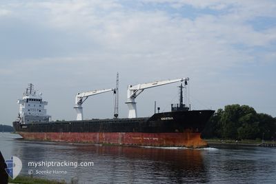
UNISTAR
General Cargo
Current Trip
TBN
| Time Travelled | 19 h, 12 mins |
|---|---|
| Remaining Time | --- |
| Distance Travelled | 7.72 nm |
| Remaining Distance | --- |
| AVG Speed | 8.2 Knop |
| MAX Speed | 9.6 Knop |
| AVG Wind | 13.3 knots |
| MAX Wind | 14 knots |
| MIN Temp | 25°C / 77°F |
| MAX Temp | 25.9°C / 78.62°F |
| Djupgående | 4.8 m |
| Position mottagen | 3 m sen |
Current Position
| Longitud | -97.78274° |
|---|---|
| Latitude | 22.40574° |
| Status | At anchor |
| Fart | |
| Kurs | 138° |
| Område | Gulf of Mexico |
| Station | T-AIS |
| Position mottagen | 3 m sen |
Info
Information
The current position of UNISTAR is in Gulf of Mexico with coordinates 22.40574° / -97.78274° as reported on 2024-04-25 15:25 by AIS to our vessel tracker app. The vessel's current speed is 0 Knop
The vessel UNISTAR (IMO: 9559901, MMSI: 305826000) is a General Cargo that was built in 2012 ( 12 År gammal ). It's sailing under the flag of [AG] Antigua Barbuda.
In this page you can find informations about the vessels current position, last detected port calls, and current voyage information. If the vessels is not in coverage by AIS you will find the latest position.
The current position of UNISTAR is detected by our AIS receivers and we are not responsible for the reliability of the data. The last position was recorded while the vessel was in Coverage by the Ais receivers of our vessel tracking app.
The current draught of UNISTAR as reported by AIS is 4.8 meters
Weather
| Temperature | 25.6°C / 78.08°F |
|---|---|
| Wind Speed | 10 knots |
| Direction | 148° SSE |
| Pressure | 1015.8 hPa |
| Humidity | 86.3 % |
| Cloud Coverage | 1 % |
Featured Company
Last Port Calls
| Port | Arrival | Departure | Time In Port |
|---|---|---|---|
| 2024-04-24 02:33 | 2024-04-24 20:16 | 17 h | |
| 2024-04-13 15:07 | 2024-04-16 00:06 | 2 d | |
| 2024-04-03 08:05 | 2024-04-03 17:21 | 9 h | |
| 2024-03-19 12:53 | |||
| 2024-02-17 13:52 | 2024-03-10 16:40 | 22 d | |
| 2024-02-07 12:48 | 2024-02-09 16:31 | 2 d | |
| 2024-02-01 18:48 | 2024-02-06 16:24 | 4 d |
Last Trips
| Origin | Departure | Destination | Arrival | Distance | |
|---|---|---|---|---|---|
| 2024-04-15 20:06 | 2024-04-23 21:33 | 2089.01 nm | |||
| 2024-04-03 13:21 | 2024-04-13 11:07 | 167.87 nm | |||
| 2024-03-19 09:53 | 2024-04-03 04:05 | 4046.88 nm | |||
| 2024-02-09 16:31 | 2024-02-17 10:52 | 2266.02 nm | |||
| 2024-02-06 16:24 | 2024-02-07 12:48 | 182.51 nm | |||
| 2024-01-29 01:55 | 2024-02-01 18:48 | 324.82 nm |
Events
| Tid | Event | Detaljer | Position / Dest | Information |
|---|---|---|---|---|
| 2024-04-24 21:22 | STOPPAR förflyttning | 7.37 nm, South East of ALTAMIRA |
22.40493 / -97.78314
TBN
|
Fart: 0.2 kn Kurs: 114° |
| 2024-04-24 21:16 | Status ändrad | At anchor Under way using engine |
22.40542 / -97.78261
TBN
|
Fart: 0.6 kn Kurs: 132° |
| 2024-04-24 20:16 | AVGÅTT HAMN |
|
22.48752 / -97.85681
TBN
|
Fart: 5.1 kn Kurs: 91° |
| 2024-04-24 20:09 | STARTAR förflyttning |
22.48609 / -97.86665
[MX] ALTAMIRA
|
Fart: 3.4 kn Kurs: 80° |
|
| 2024-04-24 20:07 | Status ändrad | Under way using engine Moored |
22.48574 / -97.86800
[MX] ALTAMIRA
|
Fart: 0.7 kn Kurs: 87° |
| 2024-04-24 19:34 | Djupgående ändrat | 4.8 5.8 |
22.48524 / -97.86842
[MX] ALTAMIRA
|
Fart: Kurs: 89° |
| 2024-04-24 19:34 | Destination ändrad | TBN MX ATM |
22.48524 / -97.86842
[MX] ALTAMIRA
|
Fart: Kurs: 89° |
| 2024-04-24 02:57 | Status ändrad | Moored Under way using engine |
22.48526 / -97.86844
[MX] ALTAMIRA
|
Fart: Kurs: 90° |
| 2024-04-24 02:54 | STOPPAR förflyttning |
22.48532 / -97.86848
[MX] ALTAMIRA
|
Fart: 0.3 kn Kurs: 88° |
|
| 2024-04-24 02:33 | ANLÄNDER HAMN |
|
22.48742 / -97.85851
[MX] ALTAMIRA
|
Fart: 3.9 kn Kurs: 269° |