
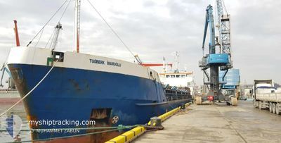
TUGBERK IMAMOGLU
General Cargo
Current Trip
| Time Travelled | 6 days |
|---|---|
| Remaining Time | 1 day |
| Distance Travelled | 1077.52 nm |
| Remaining Distance | 317.17 nm |
| AVG Speed | 7.3 Knop |
| MAX Speed | 9 Knop |
| AVG Wind | 11 knots |
| MAX Wind | 25 knots |
| MIN Temp | 15.1°C / 59.18°F |
| MAX Temp | 18.4°C / 65.12°F |
| Djupgående | 6.2 m |
| Position mottagen | 20 h, 51 m sen |
Current Position
| Longitud | --- |
|---|---|
| Latitude | --- |
| Status | Under way using engine |
| Fart | 6.6 Knop |
| Kurs | 89.4° |
| Område | Mediterranean Sea - Eastern Basin |
| Station | T-AIS |
| Position mottagen | 20 h, 51 m sen |
Info
Information
The current position of TUGBERK IMAMOGLU is in Mediterranean Sea - Eastern Basin with coordinates 36.09040° / 29.72041° as reported on 2025-12-08 09:51 by AIS to our vessel tracker app. The vessel's current speed is 6.6 Knop and is heading at the port of ISKENDERUN. The estimated time of arrival as calculated by MyShipTracking vessel tracking app is 2025-12-10 13:32 LT
The vessel TUGBERK IMAMOGLU (IMO: 9003548, MMSI: 271044604) is a General Cargo that was built in 1990 ( 35 År gammal ). It's sailing under the flag of [TR] Turkey.
In this page you can find informations about the vessels current position, last detected port calls, and current voyage information. If the vessels is not in coverage by AIS you will find the latest position.
The current position of TUGBERK IMAMOGLU is detected by our AIS receivers and we are not responsible for the reliability of the data. The last position was recorded while the vessel was in Coverage by the Ais receivers of our vessel tracking app.
The current draught of TUGBERK IMAMOGLU as reported by AIS is 6.2 meters
Weather
| Temperature | 17.5°C / 63.5°F |
|---|---|
| Wind Speed | 6 knots |
| Direction | 43° NE |
| Pressure | 1013 hPa |
| Humidity | 51.7 % |
| Cloud Coverage | 100 % |
Featured Company
Last Port Calls
| Port | Arrival | Departure | Time In Port |
|---|---|---|---|
| 2025-12-01 12:30 | 2025-12-02 16:49 | 1 d | |
| 2025-11-27 14:37 | 2025-11-30 07:03 | 2 d | |
| 2025-11-18 13:16 | 2025-11-21 14:09 | 3 d | |
| 2025-11-12 14:28 | 2025-11-14 09:26 | 1 d | |
| 2025-11-03 21:45 | 2025-11-06 08:19 | 2 d | |
| 2025-10-24 15:52 | 2025-10-28 12:00 | 3 d | |
| 2025-10-19 17:28 | 2025-10-21 16:36 | 1 d | |
| 2025-10-14 09:15 | 2025-10-17 11:46 | 3 d | |
| 2025-10-08 10:44 | 2025-10-13 08:20 | 4 d | |
| 2025-10-03 21:00 | 2025-10-07 04:56 | 3 d |
Most Visited Ports (Last year)
| Port | Arrivals | |
|---|---|---|
| 8 | ||
| 5 | ||
| 4 | ||
| 3 | ||
| 3 | ||
| 3 |
Last Trips
| Origin | Departure | Destination | Arrival | Distance | |
|---|---|---|---|---|---|
| 2025-11-30 07:03 | 2025-12-01 12:30 | 199.12 nm | |||
| 2025-11-21 14:09 | 2025-11-27 14:37 | 1111.76 nm | |||
| 2025-11-14 09:26 | 2025-11-18 13:16 | 762.16 nm | |||
| 2025-11-06 08:19 | 2025-11-12 14:28 | 694.04 nm | |||
| 2025-10-28 12:00 | 2025-11-03 21:45 | 954.63 nm | |||
| 2025-10-21 16:36 | 2025-10-24 15:52 | 619.98 nm | |||
| 2025-10-17 11:46 | 2025-10-19 17:28 | 370.47 nm | |||
| 2025-10-13 08:20 | 2025-10-14 09:15 | 209.81 nm | |||
| 2025-10-07 04:56 | 2025-10-08 10:44 | 207.22 nm | |||
| 2025-09-30 20:20 | 2025-10-03 21:00 | 140.92 nm |
Events
| Tid | Event | Detaljer | Position / Dest | Information |
|---|---|---|---|---|
| 2025-12-08 17:36 | STARTAR förflyttning | 6.08 nm, East of FINIKE |
36.27833 / 30.27500
TR ISK
|
Fart: 7 kn Kurs: 154° |
| 2025-12-08 13:59 | STOPPAR förflyttning | 5.47 nm, East of FINIKE |
36.29849 / 30.26391
TR ISK
|
Fart: 0.1 kn Kurs: 88° |
| 2025-12-08 09:51 | UTANFÖR täckningsområde |
36.09040 / 29.72041
Mediterranean Sea - Eastern Basin
TR ISK
|
Fart: 6.6 kn Kurs: 89.4° |
|
| 2025-12-08 09:10 | Upptäckt i hav | Turkish part of the Mediterranean Sea - Eastern Basin |
36.08811 / 29.62225
Mediterranean Sea - Eastern Basin
TR ISK
|
Fart: 6.8 kn Kurs: 85.6° |
| 2025-12-08 08:49 | I täckningsområde |
36.08460 / 29.58273
Mediterranean Sea - Eastern Basin
TR ISK
|
Fart: 6.4 kn Kurs: 84.3° |
|
| 2025-12-08 07:26 | UTANFÖR täckningsområde |
36.07933 / 29.38366
Mediterranean Sea - Eastern Basin
TR ISK
|
Fart: 6.6 kn Kurs: 87.6° |
|
| 2025-12-08 07:20 | Upptäckt i hav | Greek part of the Mediterranean Sea - Eastern Basin |
36.07879 / 29.36998
Mediterranean Sea - Eastern Basin
TR ISK
|
Fart: 6.5 kn Kurs: 86.1° |
| 2025-12-08 07:06 | Status ändrad | Under way using engine Default |
36.07735 / 29.33697
TR ISK
|
Fart: 6 kn Kurs: 86° |
| 2025-12-08 06:48 | Status ändrad | Default Under way using engine |
36.07500 / 29.29667
TR ISK
|
Fart: 6.4 kn Kurs: 87.1° |
| 2025-12-08 06:40 | Upptäckt i hav | Turkish part of the Mediterranean Sea - Eastern Basin |
36.07476 / 29.28048
Mediterranean Sea - Eastern Basin
TR ISK
|
Fart: 6.4 kn Kurs: 87.1° |