
TIMUCIN A
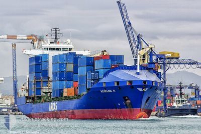
Container Ship
Current Trip
TNSFA
| Time Travelled | 3 days |
|---|---|
| Remaining Time | --- |
| Distance Travelled | 290.22 nm |
| Remaining Distance | --- |
| AVG Speed | 11 Knop |
| MAX Speed | 13.6 Knop |
| AVG Wind | 20.2 knots |
| MAX Wind | 25.9 knots |
| MIN Temp | 14°C / 57.2°F |
| MAX Temp | 20.2°C / 68.36°F |
| Djupgående | 8.8 m |
| Position mottagen | 8 d sen |
Current Position
| Longitud | 22.24895° |
|---|---|
| Latitude | 35.83567° |
| Status | Under way using engine |
| Fart | 11.6 Knop |
| Kurs | 243.8° |
| Område | Mediterranean Sea - Eastern Basin |
| Station | T-AIS |
| Position mottagen | 8 d sen |
Info
Information
The current position of TIMUCIN A is in Mediterranean Sea - Eastern Basin with coordinates 35.83567° / 22.24895° as reported on 2024-04-17 15:31 by AIS to our vessel tracker app. The vessel's current speed is 11.6 Knop
The vessel TIMUCIN A (IMO: 9163984, MMSI: 271043491) is a Container Ship that was built in 1998 ( 26 År gammal ). It's sailing under the flag of [TR] Turkey.
In this page you can find informations about the vessels current position, last detected port calls, and current voyage information. If the vessels is not in coverage by AIS you will find the latest position.
The current position of TIMUCIN A is detected by our AIS receivers and we are not responsible for the reliability of the data. The last position was recorded while the vessel was in Coverage by the Ais receivers of our vessel tracking app.
The current draught of TIMUCIN A as reported by AIS is 8.8 meters
Weather
| Temperature | 12.8°C / 55.04°F |
|---|---|
| Wind Speed | 10 knots |
| Direction | 258° WSW |
| Pressure | 1014.5 hPa |
| Humidity | 60.6 % |
| Cloud Coverage | 54 % |
Featured Company
Last Port Calls
| Port | Arrival | Departure | Time In Port |
|---|---|---|---|
| 2024-04-19 17:56 | 2024-04-22 12:08 | 2 d | |
| 2024-04-15 10:04 | 2024-04-16 02:50 | 16 h | |
| 2024-04-13 13:03 | 2024-04-14 14:40 | 1 d | |
| 2024-04-09 23:23 | 2024-04-11 06:52 | 1 d | |
| 2024-04-04 23:04 | 2024-04-07 12:25 | 2 d | |
| 2024-04-03 23:03 | 2024-04-04 16:51 | 17 h | |
| 2024-03-31 23:12 | 2024-04-02 20:36 | 1 d | |
| 2024-03-25 20:19 | 2024-03-27 00:54 | 1 d | |
| 2024-03-21 12:40 | 2024-03-22 22:57 | 1 d | |
| 2024-03-19 18:21 | 2024-03-20 10:03 | 15 h |
Last Trips
| Origin | Departure | Destination | Arrival | Distance | |
|---|---|---|---|---|---|
| 2024-04-16 05:50 | 2024-04-19 18:56 | 1059.10 nm | |||
| 2024-04-14 17:40 | 2024-04-15 13:04 | 55.98 nm | |||
| 2024-04-11 09:52 | 2024-04-13 16:03 | 316.29 nm | |||
| 2024-04-07 14:25 | 2024-04-10 02:23 | 808.81 nm | |||
| 2024-04-04 18:51 | 2024-04-05 01:04 | 76.25 nm | |||
| 2024-04-02 22:36 | 2024-04-04 01:03 | 296.97 nm | |||
| 2024-03-27 02:54 | 2024-04-01 01:12 | 250.17 nm | |||
| 2024-03-23 01:57 | 2024-03-25 22:19 | 879.34 nm | |||
| 2024-03-20 13:03 | 2024-03-21 15:40 | 58.80 nm | |||
| 2024-03-19 15:13 | 2024-03-19 21:21 | 69.43 nm |
Events
| Tid | Event | Detaljer | Position / Dest | Information |
|---|---|---|---|---|
| 2024-04-22 12:08 | STARTAR förflyttning | 0.53 nm, South East of SFAX |
34.71503 / 10.78351
TNSFA
|
Fart: 10.1 kn Kurs: 141° |
| 2024-04-22 12:08 | AVGÅTT HAMN |
|
34.71503 / 10.78351
TNSFA
|
Fart: 1.1 kn Kurs: 118° |
| 2024-04-19 18:12 | STOPPAR förflyttning |
34.72796 / 10.76885
[TN] SFAX
|
Fart: 0.3 kn Kurs: 86° |
|
| 2024-04-19 17:56 | ANLÄNDER HAMN |
|
34.72309 / 10.77594
[TN] SFAX
|
Fart: 5.8 kn Kurs: 322° |
| 2024-04-17 15:40 | Status ändrad | Default Under way using engine |
35.82341 / 22.21553
TNSFA
|
Fart: 11.6 kn Kurs: 243.8° |
| 2024-04-17 15:31 | UTANFÖR täckningsområde |
35.83567 / 22.24895
Mediterranean Sea - Eastern Basin
TNSFA
|
Fart: 11.6 kn Kurs: 243.8° |
|
| 2024-04-17 15:16 | Upptäckt i hav | Greek part of the Mediterranean Sea - Eastern Basin |
35.85598 / 22.30630
Mediterranean Sea - Eastern Basin
TNSFA
|
Fart: 11.6 kn Kurs: 251.6° |
| 2024-04-17 15:14 | Status ändrad | Under way using engine Default |
35.85741 / 22.31059
TNSFA
|
Fart: 11.5 kn Kurs: 251° |
| 2024-04-17 15:01 | I täckningsområde |
35.85598 / 22.30630
Mediterranean Sea - Eastern Basin
TNSFA
|
Fart: 11.6 kn Kurs: 251.6° |
|
| 2024-04-17 11:07 | UTANFÖR täckningsområde |
36.12121 / 23.26909
Aegean Sea
TNSFA
|
Fart: 13.2 kn Kurs: 222.2° |