
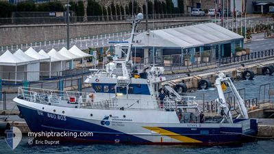
TETHYS 2
Other Type
Current Trip
| Trip Time | 4 h, 55 mins |
|---|---|
| Trip Distance | 23.68 nm |
| AVG Speed | 4.6 Knop |
| MAX Speed | 9.6 Knop |
| Djupgående | 3.2 m |
| AVG Wind | 11.8 knots |
| MAX Wind | 20.8 knots |
| MIN Temp | 9.6°C / 49.28°F |
| MAX Temp | 14.2°C / 57.56°F |
| Position mottagen | 1 m sen |
Current Position
| Longitud | 7.28531° |
|---|---|
| Latitude | 43.69385° |
| Status | Moored |
| Fart | |
| Kurs | 21° |
| Område | Mediterranean Sea - Western Basin |
| Station | T-AIS |
| Position mottagen | 1 m sen |
Info
Information
The current position of TETHYS 2 is in Mediterranean Sea - Western Basin with coordinates 43.69385° / 7.28531° as reported on 2024-04-19 05:16 by AIS to our vessel tracker app. The vessel's current speed is 0 Knop and is currently inside the port of NICE.
The vessel TETHYS 2 (IMO: 9066007, MMSI: 227212000) is a Other Type It's sailing under the flag of [FR] France.
In this page you can find informations about the vessels current position, last detected port calls, and current voyage information. If the vessels is not in coverage by AIS you will find the latest position.
The current position of TETHYS 2 is detected by our AIS receivers and we are not responsible for the reliability of the data. The last position was recorded while the vessel was in Coverage by the Ais receivers of our vessel tracking app.
The current draught of TETHYS 2 as reported by AIS is 3.2 meters
Weather
| Temperature | 5.8°C / 42.44°F |
|---|---|
| Wind Speed | 7 knots |
| Direction | 329° NNW |
| Pressure | 1018 hPa |
| Humidity | 51.6 % |
| Cloud Coverage | --- |
Featured Company
Last Port Calls
| Port | Arrival | Departure | Time In Port |
|---|---|---|---|
| 2024-04-18 12:31 | |||
| 2024-04-17 14:19 | 2024-04-18 07:36 | 17 h | |
| 2024-04-16 15:28 | 2024-04-17 07:31 | 16 h | |
| 2024-04-14 14:06 | 2024-04-16 07:42 | 1 d | |
| 2024-04-13 03:59 | 2024-04-14 05:12 | 1 d | |
| 2024-04-11 17:17 | 2024-04-12 05:14 | 11 h | |
| 2024-04-09 16:00 | 2024-04-11 06:14 | 1 d | |
| 2024-04-07 16:41 | 2024-04-09 05:03 | 1 d | |
| 2024-04-07 06:20 | 2024-04-07 06:40 | 19 m | |
| 2024-04-04 14:44 | 2024-04-06 17:06 | 2 d |
Most Visited Ports (Last year)
| Port | Arrivals | |
|---|---|---|
| 67 | ||
| 30 | ||
| 3 | ||
| 2 | ||
| 1 | ||
| 1 |
Last Trips
| Origin | Departure | Destination | Arrival | Distance | |
|---|---|---|---|---|---|
| 2024-04-18 09:36 | 2024-04-18 14:31 | 23.68 nm | |||
| 2024-04-17 09:31 | 2024-04-17 16:19 | 37.19 nm | |||
| 2024-04-16 09:42 | 2024-04-16 17:28 | 38.53 nm | |||
| 2024-04-14 07:12 | 2024-04-14 16:06 | 87.57 nm | |||
| 2024-04-12 07:14 | 2024-04-13 05:59 | 95.20 nm | |||
| 2024-04-11 08:14 | 2024-04-11 19:17 | 55.84 nm | |||
| 2024-04-09 07:03 | 2024-04-09 18:00 | 63.62 nm | |||
| 2024-04-07 08:40 | 2024-04-07 18:41 | 68.03 nm | |||
| 2024-04-06 19:06 | 2024-04-07 08:20 | 133.20 nm | |||
| 2024-04-04 09:44 | 2024-04-04 16:44 | 43.80 nm |
Events
| Tid | Event | Detaljer | Position / Dest | Information |
|---|---|---|---|---|
| 2024-04-18 12:44 | Status ändrad | Moored Under way using engine |
43.69386 / 7.28531
[FR] NICE
|
Fart: Kurs: 20° |
| 2024-04-18 12:38 | STOPPAR förflyttning |
43.69392 / 7.28524
[FR] NICE
|
Fart: 0.1 kn Kurs: 350° |
|
| 2024-04-18 12:31 | ANLÄNDER HAMN |
|
43.68905 / 7.29068
[FR] NICE
|
Fart: 4.8 kn Kurs: 346° |
| 2024-04-18 12:29 | STARTAR förflyttning | 0.22 nm, South of NICE |
43.68736 / 7.29117
FRNCE
|
Fart: 4.1 kn Kurs: 357° |
| 2024-04-18 12:21 | STOPPAR förflyttning | 0.36 nm, South of NICE |
43.68497 / 7.29153
FRNCE
|
Fart: 0.3 kn Kurs: 1° |
| 2024-04-18 11:04 | Destination ändrad | FRNCE OCEANOGRAPHIC WORKS |
43.63665 / 7.43082
FRNCE
|
Fart: 10 kn Kurs: 285° |
| 2024-04-18 11:04 | ETA ändrat | 2024/04/18 12:00 2024/04/18 15:00 |
43.63665 / 7.43082
FRNCE
|
Fart: 10 kn Kurs: 285° |
| 2024-04-18 10:01 | Status ändrad | Under way using engine Restricted manoeuverability |
43.56423 / 7.42860
OCEANOGRAPHIC WORKS
|
Fart: 1.5 kn Kurs: 44° |
| 2024-04-18 10:01 | Status ändrad | Restricted manoeuverability Under way using engine |
43.56385 / 7.42836
OCEANOGRAPHIC WORKS
|
Fart: 1.7 kn Kurs: 44° |
| 2024-04-18 10:01 | Status ändrad | Under way using engine Restricted manoeuverability |
43.56390 / 7.42839
OCEANOGRAPHIC WORKS
|
Fart: 1.2 kn Kurs: 46° |