
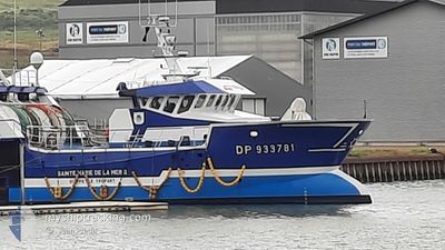
F/V STEMARIELAMERII
Fishing
Current Trip
PECHE
| Time Travelled | 28 days |
|---|---|
| Remaining Time | --- |
| Distance Travelled | 292.12 nm |
| Remaining Distance | --- |
| AVG Speed | 6.1 Knop |
| MAX Speed | 11.8 Knop |
| AVG Wind | 11.6 knots |
| MAX Wind | 17.9 knots |
| MIN Temp | 8.9°C / 48.02°F |
| MAX Temp | 13.4°C / 56.12°F |
| Djupgående | 1 m |
| Position mottagen | 6 d sen |
Current Position
| Longitud | -0.29707° |
|---|---|
| Latitude | 50.06384° |
| Status | Restricted manoeuverability |
| Fart | 3.8 Knop |
| Kurs | 25.4° |
| Område | English Channel |
| Station | T-AIS |
| Position mottagen | 6 d sen |
Info
Information
The current position of F/V STEMARIELAMERII is in English Channel with coordinates 50.06384° / -0.29707° as reported on 2024-04-13 21:02 by AIS to our vessel tracker app. The vessel's current speed is 3.8 Knop
The vessel F/V STEMARIELAMERII (IMO: 9849411, MMSI: 228099700) is a Fishing It's sailing under the flag of [FR] France.
In this page you can find informations about the vessels current position, last detected port calls, and current voyage information. If the vessels is not in coverage by AIS you will find the latest position.
The current position of F/V STEMARIELAMERII is detected by our AIS receivers and we are not responsible for the reliability of the data. The last position was recorded while the vessel was in Coverage by the Ais receivers of our vessel tracking app.
The current draught of F/V STEMARIELAMERII as reported by AIS is 1 meters
Weather
| Temperature | 11.9°C / 53.42°F |
|---|---|
| Wind Speed | 17 knots |
| Direction | 270° W |
| Pressure | 1024.2 hPa |
| Humidity | 89.1 % |
| Cloud Coverage | 90 % |
Featured Company
Last Port Calls
| Port | Arrival | Departure | Time In Port |
|---|---|---|---|
| 2024-03-21 17:17 | 2024-03-22 13:20 | 20 h | |
| 2024-02-28 22:15 | 2024-02-29 00:45 | 2 h | |
| 2024-02-27 20:35 | 2024-02-28 00:30 | 3 h | |
| 2024-02-26 11:53 | 2024-02-26 22:55 | 11 h | |
| 2024-02-22 10:53 | 2024-02-22 21:44 | 10 h | |
| 2024-02-21 23:12 | 2024-02-22 00:33 | 1 h | |
| 2024-02-12 22:13 | 2024-02-12 23:25 | 1 h |
Last Trips
| Origin | Departure | Destination | Arrival | Distance | |
|---|---|---|---|---|---|
| 2024-02-29 01:45 | 2024-03-21 18:17 | 794.12 nm | |||
| 2024-02-28 01:30 | 2024-02-28 23:15 | 55.95 nm | |||
| 2024-02-26 23:55 | 2024-02-27 21:35 | 69.45 nm | |||
| 2024-02-22 22:44 | 2024-02-26 12:53 | 102.09 nm | |||
| 2024-02-22 01:33 | 2024-02-22 11:53 | 8.45 nm | |||
| 2024-02-22 01:33 | 2024-02-22 00:12 | 8.45 nm | |||
| 2024-01-29 00:01 | 2024-02-12 23:13 | 618.06 nm |
Events
| Tid | Event | Detaljer | Position / Dest | Information |
|---|---|---|---|---|
| 2024-04-13 21:02 | UTANFÖR täckningsområde |
50.06384 / -.29707
English Channel
|
Fart: 3.8 kn Kurs: 25.4° |
|
| 2024-04-13 19:24 | STARTAR förflyttning |
50.01139 / -.36789
PECHE
|
Fart: 4.6 kn Kurs: 60.7° |
|
| 2024-04-13 19:19 | STOPPAR förflyttning |
50.01006 / -.37002
PECHE
|
Fart: 0.2 kn Kurs: 511° |
|
| 2024-04-13 18:32 | STARTAR förflyttning |
49.97950 / -.39026
PECHE
|
Fart: 4.2 kn Kurs: 314.4° |
|
| 2024-04-13 18:28 | STOPPAR förflyttning |
49.97799 / -.38721
PECHE
|
Fart: 0.2 kn Kurs: 511° |
|
| 2024-04-13 13:58 | STARTAR förflyttning | 20.67 nm, North West of ANTIFER |
49.88959 / -.25713
PECHE
|
Fart: 4.4 kn Kurs: 269.8° |
| 2024-04-13 13:52 | STOPPAR förflyttning | 20.58 nm, North West of ANTIFER |
49.88960 / -.25404
PECHE
|
Fart: 0.2 kn Kurs: 511° |
| 2024-04-13 05:48 | STARTAR förflyttning |
49.88186 / -.33376
PECHE
|
Fart: 3.2 kn Kurs: 79.6° |
|
| 2024-04-13 05:36 | STOPPAR förflyttning |
49.88170 / -.33879
PECHE
|
Fart: 0.3 kn Kurs: 511° |
|
| 2024-04-13 04:45 | I täckningsområde |
49.89382 / -.37838
English Channel
|
Fart: 1.8 kn Kurs: 89.9° |