
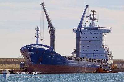
SONATA
General Cargo
Current Trip
| Time Travelled | 2 days |
|---|---|
| Remaining Time | 3 h, 24 mins |
| Distance Travelled | 367.72 nm |
| Remaining Distance | 18.45 nm |
| AVG Speed | 11.4 Knop |
| MAX Speed | 12.4 Knop |
| AVG Wind | 13.1 knots |
| MAX Wind | 20 knots |
| MIN Temp | 14.6°C / 58.28°F |
| MAX Temp | 24.5°C / 76.1°F |
| Djupgående | 6.8 m |
| Position mottagen | 1 m sen |
Current Position
| Longitud | -9.00577° |
|---|---|
| Latitude | 37.63310° |
| Status | Under way using engine |
| Fart | 1.8 Knop |
| Kurs | 259° |
| Område | North Atlantic Ocean |
| Station | T-AIS |
| Position mottagen | 1 m sen |
Info
Information
The current position of SONATA is in North Atlantic Ocean with coordinates 37.63310° / -9.00577° as reported on 2024-04-25 08:08 by AIS to our vessel tracker app. The vessel's current speed is 1.8 Knop and is heading at the port of SINES. The estimated time of arrival as calculated by MyShipTracking vessel tracking app is 2024-04-25 11:33 LT
The vessel SONATA (IMO: 9316103, MMSI: 277562000) is a General Cargo that was built in 2006 ( 18 År gammal ). It's sailing under the flag of [LT] Lithuania.
In this page you can find informations about the vessels current position, last detected port calls, and current voyage information. If the vessels is not in coverage by AIS you will find the latest position.
The current position of SONATA is detected by our AIS receivers and we are not responsible for the reliability of the data. The last position was recorded while the vessel was in Coverage by the Ais receivers of our vessel tracking app.
The current draught of SONATA as reported by AIS is 6.8 meters
Weather
| Temperature | 15.1°C / 59.18°F |
|---|---|
| Wind Speed | 19 knots |
| Direction | 346° NNW |
| Pressure | 1014.7 hPa |
| Humidity | 76.5 % |
| Cloud Coverage | 100 % |
Featured Company
Last Port Calls
| Port | Arrival | Departure | Time In Port |
|---|---|---|---|
| 2024-04-20 22:27 | 2024-04-22 13:44 | 1 d | |
| 2024-04-14 23:21 | 2024-04-17 00:27 | 2 d | |
| 2024-04-08 19:57 | 2024-04-09 05:30 | 9 h | |
| 2024-04-05 16:12 | 2024-04-06 00:57 | 8 h | |
| 2024-04-04 05:02 | 2024-04-04 17:14 | 12 h | |
| 2024-04-03 06:54 | 2024-04-03 20:42 | 13 h | |
| 2024-03-28 15:36 | 2024-03-29 08:04 | 16 h | |
| 2024-03-25 21:12 | 2024-03-26 18:37 | 21 h | |
| 2024-03-17 06:03 | 2024-03-20 05:41 | 2 d | |
| 2024-03-15 05:41 | 2024-03-16 15:43 | 1 d |
Last Trips
| Origin | Departure | Destination | Arrival | Distance | |
|---|---|---|---|---|---|
| 2024-04-17 01:27 | 2024-04-20 23:27 | 617.14 nm | |||
| 2024-04-09 07:30 | 2024-04-15 00:21 | 671.15 nm | |||
| 2024-04-06 03:57 | 2024-04-08 21:57 | 686.94 nm | |||
| 2024-04-04 20:14 | 2024-04-05 19:12 | 308.40 nm | |||
| 2024-04-03 23:42 | 2024-04-04 08:02 | 110.71 nm | |||
| 2024-03-29 12:04 | 2024-04-03 09:54 | 718.89 nm | |||
| 2024-03-26 20:37 | 2024-03-28 19:36 | 633.37 nm | |||
| 2024-03-20 06:41 | 2024-03-25 23:12 | 990.17 nm | |||
| 2024-03-16 16:43 | 2024-03-17 07:03 | 144.86 nm | |||
| 2024-03-13 07:32 | 2024-03-15 06:41 | 597.64 nm |
Events
| Tid | Event | Detaljer | Position / Dest | Information |
|---|---|---|---|---|
| 2024-04-24 12:00 | STARTAR förflyttning | 18.34 nm, South of SINES |
37.64931 / -8.97057
PTSIE
|
Fart: 3.1 kn Kurs: 286° |
| 2024-04-23 15:07 | STOPPAR förflyttning | 14.15 nm, West of SINES |
37.95826 / -9.16395
PTSIE
|
Fart: 0.3 kn Kurs: 305° |
| 2024-04-23 11:21 | Djupgående ändrat | 6.8 7.4 |
37.32070 / -9.39266
PTSIE
|
Fart: 11.8 kn Kurs: 37° |
| 2024-04-22 23:07 | Upptäckt i hav | Portuguese part of the North Atlantic Ocean |
35.23082 / -8.69753
North Atlantic Ocean
PTSIE
|
Fart: 11.7 kn Kurs: 327° |
| 2024-04-22 22:40 | Status ändrad | Under way using engine Default |
35.15424 / -8.63884
PTSIE
|
Fart: 11.7 kn Kurs: 329° |
| 2024-04-22 22:18 | Status ändrad | Default Under way using engine |
35.09378 / -8.59355
PTSIE
|
Fart: 11.9 kn Kurs: 328.3° |
| 2024-04-22 21:30 | Status ändrad | Under way using engine Default |
34.96217 / -8.48738
PTSIE
|
Fart: 11.6 kn Kurs: 325° |
| 2024-04-22 21:27 | Status ändrad | Default Under way using engine |
34.95430 / -8.48055
PTSIE
|
Fart: 11.4 kn Kurs: 325.8° |
| 2024-04-22 20:32 | Status ändrad | Under way using engine Default |
34.80689 / -8.36049
PTSIE
|
Fart: 12 kn Kurs: 327° |
| 2024-04-22 20:14 | Status ändrad | Default Under way using engine |
34.75605 / -8.32647
PTSIE
|
Fart: 11.9 kn Kurs: 333.5° |