
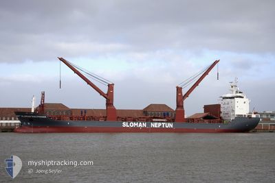
SLOMAN DISCOVERER
General Cargo
Current Trip
| Time Travelled | 7 h, 14 mins |
|---|---|
| Remaining Time | 3 days |
| Distance Travelled | 97.26 nm |
| Remaining Distance | 1210.76 nm |
| AVG Speed | 13.5 Knop |
| MAX Speed | 14.5 Knop |
| AVG Wind | 14.6 knots |
| MAX Wind | 18 knots |
| MIN Temp | 26.7°C / 80.06°F |
| MAX Temp | 27.4°C / 81.32°F |
| Djupgående | 6.2 m |
| Position mottagen | 5 h, 58 m sen |
Current Position
| Longitud | -61.98724° |
|---|---|
| Latitude | 16.95783° |
| Status | Under way using engine |
| Fart | 14.3 Knop |
| Kurs | 190.3° |
| Område | Caribbean Sea |
| Station | T-AIS |
| Position mottagen | 5 h, 58 m sen |
Info
Information
The current position of SLOMAN DISCOVERER is in Caribbean Sea with coordinates 16.95783° / -61.98724° as reported on 2024-04-24 23:30 by AIS to our vessel tracker app. The vessel's current speed is 14.3 Knop and is heading at the port of PALM BEACH. The estimated time of arrival as calculated by MyShipTracking vessel tracking app is 2024-04-29 01:33 LT
The vessel SLOMAN DISCOVERER (IMO: 9620669, MMSI: 305737000) is a General Cargo that was built in 2012 ( 12 År gammal ). It's sailing under the flag of [AG] Antigua Barbuda.
In this page you can find informations about the vessels current position, last detected port calls, and current voyage information. If the vessels is not in coverage by AIS you will find the latest position.
The current position of SLOMAN DISCOVERER is detected by our AIS receivers and we are not responsible for the reliability of the data. The last position was recorded while the vessel was in Coverage by the Ais receivers of our vessel tracking app.
The current draught of SLOMAN DISCOVERER as reported by AIS is 6.2 meters
Weather
| Temperature | 27.5°C / 81.5°F |
|---|---|
| Wind Speed | 8 knots |
| Direction | 100° E |
| Pressure | 1014.1 hPa |
| Humidity | 76.5 % |
| Cloud Coverage | 1 % |
Featured Company
Last Port Calls
| Port | Arrival | Departure | Time In Port |
|---|---|---|---|
| 2024-04-23 18:26 | 2024-04-24 22:14 | 1 d | |
| 2024-04-18 11:17 | 2024-04-20 00:15 | 1 d | |
| 2024-04-13 18:26 | 2024-04-14 12:31 | 18 h | |
| 2024-04-06 13:56 | 2024-04-07 12:31 | 22 h | |
| 2024-03-29 05:32 | 2024-03-31 02:13 | 1 d | |
| 2024-03-29 04:30 | 2024-03-29 04:52 | 22 m | |
| 2024-03-11 15:33 | 2024-03-11 16:17 | 43 m | |
| 2024-03-03 21:41 | 2024-03-06 18:30 | 2 d | |
| 2024-02-28 20:05 | 2024-03-02 15:34 | 2 d | |
| 2024-02-22 05:17 | 2024-02-23 20:21 | 1 d |
Most Visited Ports (Last year)
| Port | Arrivals | |
|---|---|---|
| 3 | ||
| 2 | ||
| 2 | ||
| 2 | ||
| 2 | ||
| 2 |
Last Trips
| Origin | Departure | Destination | Arrival | Distance | |
|---|---|---|---|---|---|
| 2024-04-19 20:15 | 2024-04-23 14:26 | 1191.32 nm | |||
| 2024-04-14 07:31 | 2024-04-18 07:17 | 1163.21 nm | |||
| 2024-04-07 07:31 | 2024-04-13 13:26 | 504.59 nm | |||
| 2024-03-30 22:13 | 2024-04-06 08:56 | 1937.49 nm | |||
| 2024-03-29 00:52 | 2024-03-29 01:32 | 3.30 nm | |||
| 2024-03-11 17:17 | 2024-03-29 00:30 | 3754.96 nm | |||
| 2024-03-06 19:30 | 2024-03-11 16:33 | 1376.90 nm | |||
| 2024-03-02 16:34 | 2024-03-03 22:41 | 2.18 nm | |||
| 2024-02-23 21:21 | 2024-02-28 21:05 | 700.80 nm | |||
| 2024-02-02 15:27 | 2024-02-22 06:17 | 101.21 nm |
Events
| Tid | Event | Detaljer | Position / Dest | Information |
|---|---|---|---|---|
| 2024-04-24 23:34 | Status ändrad | Default Under way using engine |
16.94088 / -61.99053
MX ATM > US PAB
|
Fart: 14.3 kn Kurs: 190.3° |
| 2024-04-24 23:30 | UTANFÖR täckningsområde |
16.95783 / -61.98724
Caribbean Sea
|
Fart: 14.3 kn Kurs: 190.3° |
|
| 2024-04-24 23:26 | Status ändrad | Under way using engine Default |
16.97071 / -61.98473
MX ATM > US PAB
|
Fart: 14.2 kn Kurs: 190° |
| 2024-04-24 22:38 | Status ändrad | Default Under way using engine |
17.15430 / -61.94044
MX ATM > US PAB
|
Fart: 14.2 kn Kurs: 293.9° |
| 2024-04-24 22:32 | Status ändrad | Under way using engine Default |
17.14763 / -61.91534
MX ATM > US PAB
|
Fart: 13.7 kn Kurs: 294° |
| 2024-04-24 22:26 | Status ändrad | Default Under way using engine |
17.13966 / -61.89674
MX ATM > US PAB
|
Fart: 5.2 kn Kurs: 293.3° |
| 2024-04-24 22:14 | Status ändrad | Under way using engine Default |
17.12893 / -61.87179
MX ATM > US PAB
|
Fart: 6.8 kn Kurs: 292° |
| 2024-04-24 22:14 | AVGÅTT HAMN |
|
17.12893 / -61.87179
MX ATM > US PAB
|
Fart: 6.8 kn Kurs: 292° |
| 2024-04-24 22:10 | Status ändrad | Default Under way using engine |
17.12577 / -61.86383
[AG] ST JOHNS
|
Fart: 0.4 kn Kurs: 286° |
| 2024-04-24 22:10 | STARTAR förflyttning |
17.12577 / -61.86383
[AG] ST JOHNS
|
Fart: 6.8 kn Kurs: 292° |