
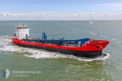
SCHENGE
General Cargo
Current Trip
| Time Travelled | 8 days |
|---|---|
| Remaining Time | 1 h, 17 mins |
| Distance Travelled | 787.90 nm |
| Remaining Distance | 16.93 nm |
| AVG Speed | 8.9 Knop |
| MAX Speed | 14.3 Knop |
| AVG Wind | 14.7 knots |
| MAX Wind | 26.2 knots |
| MIN Temp | 3.3°C / 37.94°F |
| MAX Temp | 14°C / 57.2°F |
| Djupgående | 6.5 m |
| Position mottagen | Nu |
Current Position
| Longitud | --- |
|---|---|
| Latitude | --- |
| Status | Under way using engine |
| Fart | 12.4 Knop |
| Kurs | 325° |
| Område | North Sea |
| Station | T-AIS |
| Position mottagen | Nu |
Info
Information
The current position of SCHENGE is in North Sea with coordinates 51.47918° / 3.42012° as reported on 2025-12-09 18:26 by AIS to our vessel tracker app. The vessel's current speed is 12.4 Knop and is heading at the port of TERNEUZEN. The estimated time of arrival as calculated by MyShipTracking vessel tracking app is 2025-12-09 20:44 LT
The vessel SCHENGE (IMO: 9108829, MMSI: 244146000) is a General Cargo that was built in 1996 ( 29 År gammal ). It's sailing under the flag of [NL] Netherlands.
In this page you can find informations about the vessels current position, last detected port calls, and current voyage information. If the vessels is not in coverage by AIS you will find the latest position.
The current position of SCHENGE is detected by our AIS receivers and we are not responsible for the reliability of the data. The last position was recorded while the vessel was in Coverage by the Ais receivers of our vessel tracking app.
The current draught of SCHENGE as reported by AIS is 6.5 meters
Weather
| Temperature | 12.3°C / 54.14°F |
|---|---|
| Wind Speed | 20 knots |
| Direction | 204° SSW |
| Pressure | 1007.5 hPa |
| Humidity | 76.9 % |
| Cloud Coverage | 100 % |
Featured Company
Most Visited Ports (Last year)
| Port | Arrivals | |
|---|---|---|
| 22 |
Events
| Tid | Event | Detaljer | Position / Dest | Information |
|---|---|---|---|---|
| 2025-12-09 17:01 | STARTAR förflyttning | 2.05 nm, West of ELLEWOUTSDIJK |
51.38393 / 3.76313
DRDGEAREA<>EVERINGEN
|
Fart: 5.7 kn Kurs: 317.3° |
| 2025-12-09 15:33 | STOPPAR förflyttning | 1.96 nm, West of ELLEWOUTSDIJK |
51.38271 / 3.76560
DRDGEAREA<>EVERINGEN
|
Fart: 0.3 kn Kurs: 306° |
| 2025-12-09 10:25 | Status ändrad | Under way using engine At anchor |
51.58150 / 3.08750
DRDGEAREA<>EVERINGEN
|
Fart: 1.1 kn Kurs: 29° |
| 2025-12-09 07:16 | STARTAR förflyttning | 1.87 nm, West of ELLEWOUTSDIJK |
51.38375 / 3.76792
DRDGEAREA<>EVERINGEN
|
Fart: 3.5 kn Kurs: 16° |
| 2025-12-09 05:06 | Status ändrad | At anchor Default |
51.38244 / 3.76787
DRDGEAREA<>EVERINGEN
|
Fart: 0.1 kn Kurs: 321° |
| 2025-12-09 05:03 | Status ändrad | Default At anchor |
51.38258 / 3.76818
DRDGEAREA<>EVERINGEN
|
Fart: 1.1 kn Kurs: 330° |
| 2025-12-09 03:30 | STOPPAR förflyttning | 1.77 nm, West of ELLEWOUTSDIJK |
51.38058 / 3.77113
DRDGEAREA<>EVERINGEN
|
Fart: 0.3 kn Kurs: 288° |
| 2025-12-09 03:30 | Status ändrad | At anchor Under way using engine |
51.38061 / 3.77114
DRDGEAREA<>EVERINGEN
|
Fart: 0.7 kn Kurs: 284° |
| 2025-12-08 19:14 | STARTAR förflyttning | 1.62 nm, West of ELLEWOUTSDIJK |
51.38200 / 3.77481
DRDGEAREA<>EVERINGEN
|
Fart: 6.1 kn Kurs: 323.5° |
| 2025-12-08 16:51 | STOPPAR förflyttning | 1.61 nm, West of ELLEWOUTSDIJK |
51.38012 / 3.77558
DRDGEAREA<>EVERINGEN
|
Fart: 0.2 kn Kurs: 75° |