
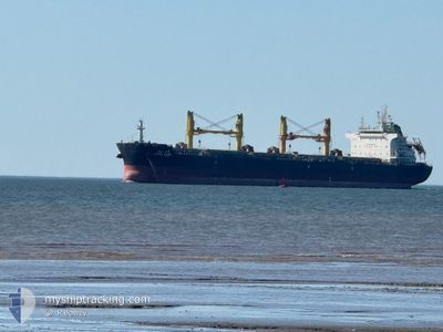
SAVITA NAREE
Cargo
Current Trip
| Time Travelled | 22 days |
|---|---|
| Remaining Time | --- |
| Distance Travelled | 5006.49 nm |
| Remaining Distance | --- |
| AVG Speed | 12.1 Knop |
| MAX Speed | 14.6 Knop |
| AVG Wind | 13.2 knots |
| MAX Wind | 24 knots |
| MIN Temp | 9.2°C / 48.56°F |
| MAX Temp | 28.3°C / 82.94°F |
| Djupgående | 13.8 m |
| Position mottagen | 5 d sen |
Current Position
| Longitud | --- |
|---|---|
| Latitude | --- |
| Status | Under way using engine |
| Fart | 0.2 Knop |
| Kurs | 296° |
| Område | Gulf of Mexico |
| Station | T-AIS |
| Position mottagen | 5 d sen |
Info
Information
The current position of SAVITA NAREE is in Gulf of Mexico with coordinates 30.08457° / -88.06890° as reported on 2025-12-03 23:29 by AIS to our vessel tracker app. The vessel's current speed is 0.2 Knop
The vessel SAVITA NAREE (IMO: 9726437, MMSI: 566645000) is a Cargo It's sailing under the flag of [SG] Singapore.
In this page you can find informations about the vessels current position, last detected port calls, and current voyage information. If the vessels is not in coverage by AIS you will find the latest position.
The current position of SAVITA NAREE is detected by our AIS receivers and we are not responsible for the reliability of the data. The last position was recorded while the vessel was in Coverage by the Ais receivers of our vessel tracking app.
The current draught of SAVITA NAREE as reported by AIS is 13.8 meters
Weather
| Temperature | 10.3°C / 50.54°F |
|---|---|
| Wind Speed | 9 knots |
| Direction | 40° NE |
| Pressure | 1023.5 hPa |
| Humidity | 74.7 % |
| Cloud Coverage | --- |
Featured Company
Last Port Calls
| Port | Arrival | Departure | Time In Port |
|---|---|---|---|
| 2025-11-11 15:52 | 2025-11-16 15:32 | 4 d | |
| 2025-10-16 10:22 | 2025-10-22 15:34 | 6 d | |
| 2025-10-11 11:41 | 2025-10-11 23:04 | 11 h |
Last Trips
| Origin | Departure | Destination | Arrival | Distance | |
|---|---|---|---|---|---|
| 2025-10-22 15:34 | 2025-11-11 15:52 | 3782.78 nm | |||
| 2025-10-11 23:04 | 2025-10-16 10:22 | 471.94 nm | |||
| 2025-09-03 10:31 | 2025-10-11 11:41 | 9588.26 nm |
Events
| Tid | Event | Detaljer | Position / Dest | Information |
|---|---|---|---|---|
| 2025-12-03 23:41 | Status ändrad | Default Under way using engine |
30.08501 / -88.06902
USMOB
|
Fart: 0.2 kn Kurs: 296° |
| 2025-12-03 23:29 | Status ändrad | Under way using engine Default |
30.08457 / -88.06890
USMOB
|
Fart: 0.2 kn Kurs: 297° |
| 2025-12-03 23:29 | UTANFÖR täckningsområde |
30.08457 / -88.06890
Gulf of Mexico
USMOB
|
Fart: 0.2 kn Kurs: 74.2° |
|
| 2025-12-03 23:27 | Status ändrad | Default Under way using engine |
30.08452 / -88.06896
USMOB
|
Fart: 0.2 kn Kurs: 297° |
| 2025-12-03 23:26 | Status ändrad | Under way using engine Default |
30.08451 / -88.06896
USMOB
|
Fart: 0.4 kn Kurs: 302° |
| 2025-12-03 23:22 | Status ändrad | Default Under way using engine |
30.08450 / -88.06924
USMOB
|
Fart: 0.3 kn Kurs: 310° |
| 2025-12-03 23:18 | Status ändrad | Under way using engine Default |
30.08455 / -88.06957
USMOB
|
Fart: 0.4 kn Kurs: 315° |
| 2025-12-03 23:18 | STOPPAR förflyttning | 10.04 nm, South of DAUPHIN ISLAND |
30.08455 / -88.06957
USMOB
|
Fart: 0.3 kn Kurs: 310° |
| 2025-12-03 23:14 | Status ändrad | Default Under way using engine |
30.08468 / -88.06985
USMOB
|
Fart: 0.5 kn Kurs: 290° |
| 2025-12-03 21:15 | ETA ändrat | 2025/12/03 22:50 2025/12/03 23:00 |
29.93303 / -87.87796
USMOB
|
Fart: 11.4 kn Kurs: 324.2° |