
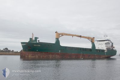
ROGALAND
General Cargo
Current Trip
ESGAR >.FIPAR
| Time Travelled | 7 days |
|---|---|
| Remaining Time | --- |
| Distance Travelled | 1993.17 nm |
| Remaining Distance | --- |
| AVG Speed | 11.2 Knop |
| MAX Speed | 13.3 Knop |
| AVG Wind | 14.7 knots |
| MAX Wind | 28.9 knots |
| MIN Temp | 4.7°C / 40.46°F |
| MAX Temp | 19.1°C / 66.38°F |
| Djupgående | 7.3 m |
| Position mottagen | Nu |
Current Position
| Longitud | 9.82727° |
|---|---|
| Latitude | 57.65837° |
| Status | Under way using engine |
| Fart | 11.9 Knop |
| Kurs | 57.5° |
| Område | Skaggerak |
| Station | T-AIS |
| Position mottagen | Nu |
Info
Information
The current position of ROGALAND is in Skaggerak with coordinates 57.65837° / 9.82727° as reported on 2024-04-20 00:32 by AIS to our vessel tracker app. The vessel's current speed is 11.9 Knop
The vessel ROGALAND (IMO: 9505596, MMSI: 305677000) is a General Cargo that was built in 2011 ( 13 År gammal ). It's sailing under the flag of [AG] Antigua Barbuda.
In this page you can find informations about the vessels current position, last detected port calls, and current voyage information. If the vessels is not in coverage by AIS you will find the latest position.
The current position of ROGALAND is detected by our AIS receivers and we are not responsible for the reliability of the data. The last position was recorded while the vessel was in Coverage by the Ais receivers of our vessel tracking app.
The current draught of ROGALAND as reported by AIS is 7.3 meters
Weather
| Temperature | 4.9°C / 40.82°F |
|---|---|
| Wind Speed | 6 knots |
| Direction | 32° NNE |
| Pressure | 1012.9 hPa |
| Humidity | 57.9 % |
| Cloud Coverage | 40 % |
Featured Company
Last Port Calls
| Port | Arrival | Departure | Time In Port |
|---|---|---|---|
| 2024-04-11 07:28 | 2024-04-12 13:45 | 1 d | |
| 2024-04-07 17:11 | 2024-04-09 11:39 | 1 d | |
| 2024-04-05 06:56 | 2024-04-06 10:25 | 1 d | |
| 2024-03-28 15:20 | 2024-03-28 16:33 | 1 h | |
| 2024-03-10 08:02 | 2024-03-11 05:26 | 21 h | |
| 2024-02-16 16:38 |
Last Trips
| Origin | Departure | Destination | Arrival | Distance | |
|---|---|---|---|---|---|
| 2024-04-09 11:39 | 2024-04-11 09:28 | 404.10 nm | |||
| 2024-04-06 10:25 | 2024-04-07 17:11 | 263.03 nm | |||
| 2024-03-28 17:33 | 2024-04-05 06:56 | 1835.28 nm | |||
| 2024-03-11 06:26 | 2024-03-28 16:20 | 2532.75 nm |
Events
| Tid | Event | Detaljer | Position / Dest | Information |
|---|---|---|---|---|
| 2024-04-19 20:08 | Byter havsområde | Danish part of the Skaggerak Danish part of the North Sea |
57.19133 / 8.48944
Skaggerak
ESGAR >.FIPAR
|
Fart: 11.9 kn Kurs: 45.5° |
| 2024-04-19 19:32 | ETA ändrat | 2024/04/22 10:00 2024/04/22 05:00 |
57.10713 / 8.33718
ESGAR >.FIPAR
|
Fart: 11.8 kn Kurs: 45.6° |
| 2024-04-19 10:44 | Byter havsområde | Danish part of the North Sea Dutch part of the North Sea |
55.70695 / 6.85712
North Sea
ESGAR >.FIPAR
|
Fart: 10.7 kn Kurs: 43° |
| 2024-04-19 10:44 | I täckningsområde |
55.70695 / 6.85712
North Sea
ESGAR >.FIPAR
|
Fart: 10.7 kn Kurs: 43° |
|
| 2024-04-18 20:22 | UTANFÖR täckningsområde |
53.53136 / 4.78235
North Sea
ESGAR >.FIPAR
|
Fart: 11 kn Kurs: 23° |
|
| 2024-04-18 19:32 | I täckningsområde |
53.39238 / 4.68084
North Sea
ESGAR >.FIPAR
|
Fart: 11 kn Kurs: 23.4° |
|
| 2024-04-18 18:16 | UTANFÖR täckningsområde |
53.17761 / 4.52036
North Sea
ESGAR >.FIPAR
|
Fart: 11 kn Kurs: 25.1° |
|
| 2024-04-18 16:33 | I täckningsområde |
52.89509 / 4.28670
North Sea
ESGAR >.FIPAR
|
Fart: 11.5 kn Kurs: 26.1° |
|
| 2024-04-18 10:52 | Status ändrad | Default Under way using engine |
52.06307 / 3.00830
ESGAR >.FIPAR
|
Fart: 12.5 kn Kurs: 47.9° |
| 2024-04-18 10:50 | UTANFÖR täckningsområde |
52.05873 / 3.00063
North Sea
ESGAR >.FIPAR
|
Fart: 12.5 kn Kurs: 47.9° |