
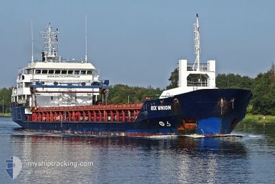
RIX UNION
General Cargo
Current Trip
NL VEL
| Time Travelled | 3 days |
|---|---|
| Remaining Time | --- |
| Distance Travelled | 728.90 nm |
| Remaining Distance | --- |
| AVG Speed | 7.4 Knop |
| MAX Speed | 12 Knop |
| AVG Wind | 22.3 knots |
| MAX Wind | 31 knots |
| MIN Temp | 9.2°C / 48.56°F |
| MAX Temp | 16.4°C / 61.52°F |
| Djupgående | 5.5 m |
| Position mottagen | 11 h, 7 m sen |
Current Position
| Longitud | -4.40866° |
|---|---|
| Latitude | 49.20183° |
| Status | Under way using engine |
| Fart | 11.6 Knop |
| Kurs | 62° |
| Område | English Channel |
| Station | T-AIS |
| Position mottagen | 11 h, 7 m sen |
Info
Information
The current position of RIX UNION is in English Channel with coordinates 49.20183° / -4.40866° as reported on 2024-04-19 15:40 by AIS to our vessel tracker app. The vessel's current speed is 11.6 Knop
The vessel RIX UNION (IMO: 9256559, MMSI: 209992000) is a General Cargo that was built in 2001 ( 23 År gammal ). It's sailing under the flag of [CY] Cyprus.
In this page you can find informations about the vessels current position, last detected port calls, and current voyage information. If the vessels is not in coverage by AIS you will find the latest position.
The current position of RIX UNION is detected by our AIS receivers and we are not responsible for the reliability of the data. The last position was recorded while the vessel was in Coverage by the Ais receivers of our vessel tracking app.
The current draught of RIX UNION as reported by AIS is 5.5 meters
Weather
| Temperature | 9.2°C / 48.56°F |
|---|---|
| Wind Speed | 17 knots |
| Direction | 61° ENE |
| Pressure | 1025.4 hPa |
| Humidity | 72.3 % |
| Cloud Coverage | 56 % |
Featured Company
Last Port Calls
| Port | Arrival | Departure | Time In Port |
|---|---|---|---|
| 2024-04-09 14:23 | 2024-04-16 13:54 | 6 d | |
| 2024-03-31 21:37 | 2024-04-02 11:02 | 1 d | |
| 2024-03-26 18:41 | 2024-03-28 05:33 | 1 d | |
| 2024-03-26 04:05 | 2024-03-26 17:03 | 12 h | |
| 2024-03-11 12:19 | 2024-03-13 22:31 | 2 d | |
| 2024-03-06 01:59 | 2024-03-07 01:32 | 23 h | |
| 2024-03-02 11:33 | 2024-03-02 13:35 | 2 h | |
| 2024-02-26 19:34 | 2024-02-29 16:23 | 2 d | |
| 2024-02-22 06:38 | 2024-02-25 22:59 | 3 d | |
| 2024-02-20 00:30 | 2024-02-20 20:18 | 19 h |
Last Trips
| Origin | Departure | Destination | Arrival | Distance | |
|---|---|---|---|---|---|
| 2024-04-02 13:02 | 2024-04-09 15:23 | 551.90 nm | |||
| 2024-03-28 06:33 | 2024-03-31 23:37 | 809.34 nm | |||
| 2024-03-26 18:03 | 2024-03-26 19:41 | 19.16 nm | |||
| 2024-03-13 22:31 | 2024-03-26 05:05 | 990.57 nm | |||
| 2024-03-07 01:32 | 2024-03-11 12:19 | 818.60 nm | |||
| 2024-03-02 14:35 | 2024-03-06 01:59 | 813.14 nm | |||
| 2024-02-29 17:23 | 2024-03-02 12:33 | 407.68 nm | |||
| 2024-02-26 00:59 | 2024-02-26 20:34 | 126.02 nm | |||
| 2024-02-20 21:18 | 2024-02-22 08:38 | 319.78 nm | |||
| 2024-02-19 12:56 | 2024-02-20 01:30 | 147.16 nm |
Events
| Tid | Event | Detaljer | Position / Dest | Information |
|---|---|---|---|---|
| 2024-04-19 15:44 | Status ändrad | Default Under way using engine |
49.20820 / -4.39067
NL VEL
|
Fart: 11.6 kn Kurs: 62° |
| 2024-04-19 15:40 | UTANFÖR täckningsområde |
49.20183 / -4.40866
English Channel
NL VEL
|
Fart: 11.6 kn Kurs: 62° |
|
| 2024-04-19 13:58 | Byter havsområde | French part of the English Channel French part of the Celtic Sea |
49.03875 / -4.84880
English Channel
NL VEL
|
Fart: 11.9 kn Kurs: 58.3° |
| 2024-04-19 08:15 | Djupgående ändrat | 5.5 5.6 |
48.28480 / -5.96577
NL VEL
|
Fart: 10.6 kn Kurs: 28.9° |
| 2024-04-19 08:15 | ETA ändrat | 2024/04/21 07:00 2024/04/20 22:00 |
48.28480 / -5.96577
NL VEL
|
Fart: 10.6 kn Kurs: 28.9° |
| 2024-04-19 07:44 | Upptäckt i hav | French part of the Celtic Sea |
48.20439 / -6.02655
Celtic Sea
NL VEL
|
Fart: 10.5 kn Kurs: 27.3° |
| 2024-04-19 07:44 | Status ändrad | Under way using engine Default |
48.20439 / -6.02655
NL VEL
|
Fart: 10.6 kn Kurs: 30° |
| 2024-04-19 07:44 | I täckningsområde |
48.20439 / -6.02655
Celtic Sea
NL VEL
|
Fart: 10.5 kn Kurs: 27.3° |
|
| 2024-04-18 00:36 | Status ändrad | Default Under way using engine |
43.59350 / -9.47386
NL VEL
|
Fart: 6.4 kn Kurs: 32.5° |
| 2024-04-18 00:28 | UTANFÖR täckningsområde |
43.58108 / -9.48256
North Atlantic Ocean
NL VEL
|
Fart: 6.4 kn Kurs: 32.5° |