
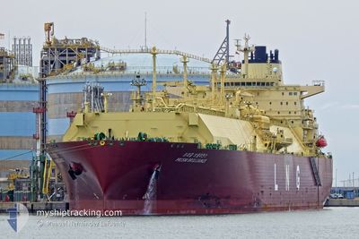
PRISM BRILLIANCE
Tanker
Current Trip
| Time Travelled | 2 days |
|---|---|
| Remaining Time | --- |
| Distance Travelled | 318.74 nm |
| Remaining Distance | --- |
| AVG Speed | 12.6 Knop |
| MAX Speed | 17.3 Knop |
| AVG Wind | 6.3 knots |
| MAX Wind | 11 knots |
| MIN Temp | 26.4°C / 79.52°F |
| MAX Temp | 30°C / 86°F |
| Djupgående | 9.4 m |
| Position mottagen | 1 d sen |
Current Position
| Longitud | 103.40481° |
|---|---|
| Latitude | 1.25081° |
| Status | Under way using engine |
| Fart | 17.1 Knop |
| Kurs | 303.6° |
| Område | Malacca Strait |
| Station | T-AIS |
| Position mottagen | 1 d sen |
Info
Information
The current position of PRISM BRILLIANCE is in Malacca Strait with coordinates 1.25081° / 103.40481° as reported on 2024-04-17 18:26 by AIS to our vessel tracker app. The vessel's current speed is 17.1 Knop and is heading at the port of FREEPORT (TX). The estimated time of arrival as calculated by MyShipTracking vessel tracking app is 2024-05-21 14:00 LT
The vessel PRISM BRILLIANCE (IMO: 9810551, MMSI: 371086000) is a Tanker It's sailing under the flag of [PA] Panama.
In this page you can find informations about the vessels current position, last detected port calls, and current voyage information. If the vessels is not in coverage by AIS you will find the latest position.
The current position of PRISM BRILLIANCE is detected by our AIS receivers and we are not responsible for the reliability of the data. The last position was recorded while the vessel was in Coverage by the Ais receivers of our vessel tracking app.
The current draught of PRISM BRILLIANCE as reported by AIS is 9.4 meters
Weather
| Temperature | 26.9°C / 80.42°F |
|---|---|
| Wind Speed | 8 knots |
| Direction | 16° NNE |
| Pressure | 1008.6 hPa |
| Humidity | 85.1 % |
| Cloud Coverage | 100 % |
Featured Company
Most Visited Ports (Last year)
| Port | Arrivals | |
|---|---|---|
| 3 | ||
| 2 | ||
| 1 | ||
| 1 |
Events
| Tid | Event | Detaljer | Position / Dest | Information |
|---|---|---|---|---|
| 2024-04-17 18:33 | Status ändrad | Default Under way using engine |
1.26992 / 103.37721
MYPGG>USFPO
|
Fart: 17.1 kn Kurs: 303.6° |
| 2024-04-17 18:26 | UTANFÖR täckningsområde |
1.25081 / 103.40481
Malacca Strait
|
Fart: 17.1 kn Kurs: 303.6° |
|
| 2024-04-17 18:26 | Byter havsområde | Malaysian part of the Malacca Strait Malaysian part of the Singapore Strait |
1.24976 / 103.40638
Malacca Strait
|
Fart: 17.1 kn Kurs: 303.6° |
| 2024-04-17 18:25 | Status ändrad | Under way using engine Default |
1.24896 / 103.40756
MYPGG>USFPO
|
Fart: 16.9 kn Kurs: 293° |
| 2024-04-17 18:09 | Status ändrad | Default Under way using engine |
1.22128 / 103.48093
MYPGG>USFPO
|
Fart: 16.8 kn Kurs: 293.5° |
| 2024-04-17 17:47 | Byter havsområde | Malaysian part of the Singapore Strait Indonesian part of the Singapore Strait |
1.18965 / 103.57510
Singapore Strait
|
Fart: 15.8 kn Kurs: 284.1° |
| 2024-04-17 17:11 | Byter havsområde | Indonesian part of the Singapore Strait Singaporean part of the Singapore Strait |
1.14349 / 103.71626
Singapore Strait
|
Fart: 15 kn Kurs: 293.5° |
| 2024-04-17 16:02 | Byter havsområde | Singaporean part of the Singapore Strait Indonesian part of the Singapore Strait |
1.24864 / 103.98128
Singapore Strait
|
Fart: 14.8 kn Kurs: 252.9° |
| 2024-04-17 15:41 | Byter havsområde | Indonesian part of the Singapore Strait Malaysian part of the Singapore Strait |
1.27018 / 104.06720
Singapore Strait
|
Fart: 15.2 kn Kurs: 261.2° |
| 2024-04-17 14:05 | Byter havsområde | Malaysian part of the Singapore Strait Malaysian part of the South China Sea |
1.31366 / 104.32587
Singapore Strait
|
Fart: 15.8 kn Kurs: 232.9° |