
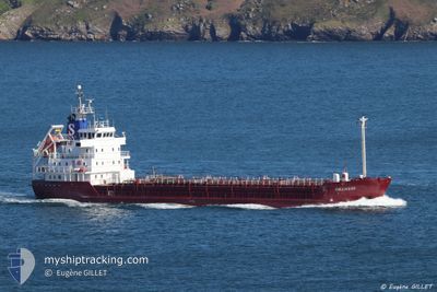
ORANESS
Chemical Tanker
Current Trip
| Time Travelled | 15 h, 8 mins |
|---|---|
| Remaining Time | 1 day |
| Distance Travelled | 121.77 nm |
| Remaining Distance | 455.61 nm |
| AVG Speed | 8.9 Knop |
| MAX Speed | 12.2 Knop |
| AVG Wind | 5.6 knots |
| MAX Wind | 12.5 knots |
| MIN Temp | -1.4°C / 29.48°F |
| MAX Temp | 5.3°C / 41.54°F |
| Djupgående | 3.8 m |
| Position mottagen | Nu |
Current Position
| Longitud | 11.70132° |
|---|---|
| Latitude | 57.64710° |
| Status | Under way using engine |
| Fart | 10.2 Knop |
| Kurs | 218.7° |
| Område | Kattegat |
| Station | T-AIS |
| Position mottagen | Nu |
Info
Information
The current position of ORANESS is in Kattegat with coordinates 57.64710° / 11.70132° as reported on 2024-04-23 08:15 by AIS to our vessel tracker app. The vessel's current speed is 10.2 Knop and is heading at the port of KLAIPEDA. The estimated time of arrival as calculated by MyShipTracking vessel tracking app is 2024-04-25 05:29 LT
The vessel ORANESS (IMO: 8416786, MMSI: 220018000) is a Chemical Tanker that was built in 1985 ( 39 År gammal ). It's sailing under the flag of [DK] Denmark.
In this page you can find informations about the vessels current position, last detected port calls, and current voyage information. If the vessels is not in coverage by AIS you will find the latest position.
The current position of ORANESS is detected by our AIS receivers and we are not responsible for the reliability of the data. The last position was recorded while the vessel was in Coverage by the Ais receivers of our vessel tracking app.
The current draught of ORANESS as reported by AIS is 3.8 meters
Weather
| Temperature | 5.3°C / 41.54°F |
|---|---|
| Wind Speed | 11 knots |
| Direction | 197° SSW |
| Pressure | 1014.1 hPa |
| Humidity | 76.1 % |
| Cloud Coverage | 100 % |
Featured Company
Last Port Calls
| Port | Arrival | Departure | Time In Port |
|---|---|---|---|
| 2024-04-20 19:04 | 2024-04-22 17:08 | 1 d | |
| 2024-04-18 08:56 | 2024-04-19 15:28 | 1 d | |
| 2024-04-17 04:28 | 2024-04-18 00:50 | 20 h | |
| 2024-04-16 08:10 | 2024-04-16 16:56 | 8 h | |
| 2024-04-15 03:46 | 2024-04-15 11:07 | 7 h | |
| 2024-04-13 16:11 | 2024-04-14 10:14 | 18 h | |
| 2024-04-10 11:05 | 2024-04-10 21:31 | 10 h | |
| 2024-04-07 12:32 | 2024-04-07 21:11 | 8 h | |
| 2024-04-04 23:28 | 2024-04-05 00:43 | 1 h | |
| 2024-04-01 20:36 | 2024-04-02 21:22 | 1 d |
Last Trips
| Origin | Departure | Destination | Arrival | Distance | |
|---|---|---|---|---|---|
| 2024-04-19 17:28 | 2024-04-20 21:04 | 220.15 nm | |||
| 2024-04-18 02:50 | 2024-04-18 10:56 | 74.76 nm | |||
| 2024-04-16 18:56 | 2024-04-17 06:28 | 103.82 nm | |||
| 2024-04-15 13:07 | 2024-04-16 10:10 | 218.25 nm | |||
| 2024-04-14 12:14 | 2024-04-15 05:46 | 106.25 nm | |||
| 2024-04-11 00:31 | 2024-04-13 18:11 | 646.91 nm | |||
| 2024-04-07 23:11 | 2024-04-10 14:05 | 638.06 nm | |||
| 2024-04-05 02:43 | 2024-04-07 14:32 | 286.11 nm | |||
| 2024-04-02 23:22 | 2024-04-05 01:28 | 514.15 nm | |||
| 2024-03-27 06:35 | 2024-04-01 22:36 | 579.31 nm |
Events
| Tid | Event | Detaljer | Position / Dest | Information |
|---|---|---|---|---|
| 2024-04-23 04:48 | Status ändrad | Under way using engine Default |
58.04901 / 12.14651
LTKLJ
|
Fart: 12.2 kn Kurs: 180° |
| 2024-04-23 04:40 | I täckningsområde |
58.04628 / 12.14725
Kattegat
LTKLJ
|
Fart: 11.8 kn Kurs: 173.2° |
|
| 2024-04-23 04:16 | STARTAR förflyttning | 8.7 nm, East of KOLHATTAN |
58.13115 / 12.11582
LTKLJ
|
Fart: 6.3 kn Kurs: 181° |
| 2024-04-23 03:57 | STOPPAR förflyttning | 8.8 nm, East of KOLHATTAN |
58.13752 / 12.11897
LTKLJ
|
Fart: Kurs: 217° |
| 2024-04-23 03:08 | Status ändrad | Default Under way using engine |
58.21557 / 12.15590
LTKLJ
|
Fart: 11.9 kn Kurs: 219.9° |
| 2024-04-23 03:00 | UTANFÖR täckningsområde |
58.23533 / 12.18945
Kattegat
LTKLJ
|
Fart: 11.9 kn Kurs: 219.9° |
|
| 2024-04-23 02:45 | STARTAR förflyttning | 7.49 nm, South of VANERSBORG |
58.26505 / 12.25077
LTKLJ
|
Fart: 3.9 kn Kurs: 265° |
| 2024-04-23 01:04 | STOPPAR förflyttning | 7.28 nm, South of VANERSBORG |
58.26649 / 12.26733
LTKLJ
|
Fart: 0.3 kn Kurs: 241° |
| 2024-04-23 00:18 | STARTAR förflyttning | 2.92 nm, South of VANERSBORG |
58.33930 / 12.35234
LTKLJ
|
Fart: 3.9 kn Kurs: 159° |
| 2024-04-23 00:02 | STOPPAR förflyttning | 2.82 nm, South of VANERSBORG |
58.34099 / 12.35111
LTKLJ
|
Fart: 0.3 kn Kurs: 157° |