
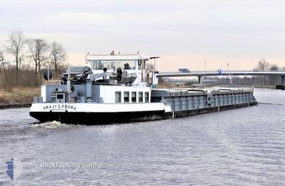
ORA ET LABORA
Cargo
Current Trip
AMSTERDAM MERCURIUSH
| Time Travelled | 21 h, 23 mins |
|---|---|
| Remaining Time | --- |
| Distance Travelled | 33.41 nm |
| Remaining Distance | --- |
| AVG Speed | 7 Knop |
| MAX Speed | 10 Knop |
| AVG Wind | 4.5 knots |
| MAX Wind | 11.3 knots |
| MIN Temp | 0.3°C / 32.54°F |
| MAX Temp | 9.1°C / 48.38°F |
| Djupgående | 2.6 m |
| Position mottagen | 16 m sen |
Current Position
| Longitud | 5.45819° |
|---|---|
| Latitude | 51.89657° |
| Status | Moored |
| Fart | |
| Kurs | 337° |
| Område | North Sea |
| Station | T-AIS |
| Position mottagen | 16 m sen |
Info
Information
The current position of ORA ET LABORA is in North Sea with coordinates 51.89657° / 5.45819° as reported on 2024-04-23 09:44 by AIS to our vessel tracker app. The vessel's current speed is 0 Knop
The vessel ORA ET LABORA (MMSI: 244660790) is a Cargo It's sailing under the flag of [NL] Netherlands.
In this page you can find informations about the vessels current position, last detected port calls, and current voyage information. If the vessels is not in coverage by AIS you will find the latest position.
The current position of ORA ET LABORA is detected by our AIS receivers and we are not responsible for the reliability of the data. The last position was recorded while the vessel was in Coverage by the Ais receivers of our vessel tracking app.
The current draught of ORA ET LABORA as reported by AIS is 2.6 meters
Weather
| Temperature | 7.9°C / 46.22°F |
|---|---|
| Wind Speed | 2 knots |
| Direction | 335° NNW |
| Pressure | 1021.3 hPa |
| Humidity | 59.2 % |
| Cloud Coverage | 77 % |
Featured Company
Last Port Calls
| Port | Arrival | Departure | Time In Port |
|---|---|---|---|
| 2024-04-22 12:37 |
Most Visited Ports (Last year)
| Port | Arrivals | |
|---|---|---|
| 13 | ||
| 12 | ||
| 8 | ||
| 6 | ||
| 4 | ||
| 4 |
Last Trips
| Origin | Departure | Destination | Arrival | Distance |
|---|
Events
| Tid | Event | Detaljer | Position / Dest | Information |
|---|---|---|---|---|
| 2024-04-23 09:28 | Status ändrad | Moored Under way using engine |
51.89656 / 5.45819
AMSTERDAM MERCURIUSH
|
Fart: Kurs: 337° |
| 2024-04-23 09:14 | STOPPAR förflyttning | 0.81 nm, North East of TIEL |
51.89657 / 5.45819
AMSTERDAM MERCURIUSH
|
Fart: Kurs: 337° |
| 2024-04-23 07:14 | STARTAR förflyttning | 0.45 nm, North of NIJMEGEN |
51.85456 / 5.82360
AMSTERDAM MERCURIUSH
|
Fart: 5.3 kn Kurs: 26.8° |
| 2024-04-23 07:06 | STOPPAR förflyttning | 0.35 nm, North of NIJMEGEN |
51.85285 / 5.82219
AMSTERDAM MERCURIUSH
|
Fart: Kurs: 26° |
| 2024-04-23 04:43 | STARTAR förflyttning | 1.66 nm, South East of BOXMEER |
51.64350 / 5.97506
AMSTERDAM MERCURIUSH
|
Fart: 5.2 kn Kurs: 296.4° |
| 2024-04-23 04:41 | Status ändrad | Under way using engine Moored |
51.64255 / 5.97759
AMSTERDAM MERCURIUSH
|
Fart: Kurs: 298° |
| 2024-04-22 16:48 | Status ändrad | Moored Under way using engine |
51.64248 / 5.97751
AMSTERDAM MERCURIUSH
|
Fart: Kurs: 298° |
| 2024-04-22 16:33 | STOPPAR förflyttning | 1.76 nm, South East of BOXMEER |
51.64247 / 5.97748
AMSTERDAM MERCURIUSH
|
Fart: 0.2 kn Kurs: 298° |
| 2024-04-22 16:30 | STARTAR förflyttning | 1.86 nm, South East of BOXMEER |
51.64163 / 5.98065
AMSTERDAM MERCURIUSH
|
Fart: 3.8 kn Kurs: 294° |
| 2024-04-22 16:28 | Status ändrad | Under way using engine Moored |
51.64072 / 5.98315
AMSTERDAM MERCURIUSH
|
Fart: Kurs: 299° |