
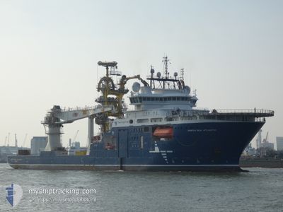
NORTH SEA ATLANTIC
Offshore Supply Ship
Current Trip
| Time Travelled | 4 days |
|---|---|
| Remaining Time | --- |
| Distance Travelled | 880.97 nm |
| Remaining Distance | --- |
| AVG Speed | 12.8 Knop |
| MAX Speed | 13.6 Knop |
| AVG Wind | 10 knots |
| MAX Wind | 15.2 knots |
| MIN Temp | 14°C / 57.2°F |
| MAX Temp | 19.9°C / 67.82°F |
| Djupgående | 6.7 m |
| Position mottagen | 1 d sen |
Current Position
| Longitud | -11.10247° |
|---|---|
| Latitude | 42.38883° |
| Status | Under way using engine |
| Fart | 11.8 Knop |
| Kurs | 14.6° |
| Område | North Atlantic Ocean |
| Station | T-AIS |
| Position mottagen | 1 d sen |
Info
Information
The current position of NORTH SEA ATLANTIC is in North Atlantic Ocean with coordinates 42.38883° / -11.10247° as reported on 2024-04-21 18:43 by AIS to our vessel tracker app. The vessel's current speed is 11.8 Knop and is heading at the port of TANANGER. The estimated time of arrival as calculated by MyShipTracking vessel tracking app is 2024-04-26 05:00 LT
The vessel NORTH SEA ATLANTIC (IMO: 9665073, MMSI: 258955000) is a Offshore Supply Ship that was built in 2014 ( 10 År gammal ). It's sailing under the flag of [NO] Norway.
In this page you can find informations about the vessels current position, last detected port calls, and current voyage information. If the vessels is not in coverage by AIS you will find the latest position.
The current position of NORTH SEA ATLANTIC is detected by our AIS receivers and we are not responsible for the reliability of the data. The last position was recorded while the vessel was in Coverage by the Ais receivers of our vessel tracking app.
The current draught of NORTH SEA ATLANTIC as reported by AIS is 6.7 meters
Weather
| Temperature | 14.2°C / 57.56°F |
|---|---|
| Wind Speed | 14 knots |
| Direction | 49° NE |
| Pressure | 1015.9 hPa |
| Humidity | 85.9 % |
| Cloud Coverage | 6 % |
Featured Company
Last Port Calls
| Port | Arrival | Departure | Time In Port |
|---|---|---|---|
| 2024-04-18 22:44 | 2024-04-19 00:07 | 1 h | |
| 2024-03-22 20:45 |
Most Visited Ports (Last year)
| Port | Arrivals | |
|---|---|---|
| 7 | ||
| 5 | ||
| 3 | ||
| 2 | ||
| 2 | ||
| 2 |
Last Trips
| Origin | Departure | Destination | Arrival | Distance | |
|---|---|---|---|---|---|
| 2024-03-22 17:45 | 2024-04-18 23:44 | 3781.99 nm |
Events
| Tid | Event | Detaljer | Position / Dest | Information |
|---|---|---|---|---|
| 2024-04-21 18:43 | UTANFÖR täckningsområde |
42.38883 / -11.10247
North Atlantic Ocean
ES LPA>NO TAE
|
Fart: 11.8 kn Kurs: 14.6° |
|
| 2024-04-21 15:01 | Byter havsområde | Spanish part of the North Atlantic Ocean Portuguese part of the North Atlantic Ocean |
41.64132 / -11.34831
North Atlantic Ocean
ES LPA>NO TAE
|
Fart: 13 kn Kurs: 14.5° |
| 2024-04-21 01:50 | I täckningsområde |
38.81332 / -12.25348
North Atlantic Ocean
ES LPA>NO TAE
|
Fart: 13.2 kn Kurs: 13.6° |
|
| 2024-04-21 00:37 | UTANFÖR täckningsområde |
38.55477 / -12.33443
North Atlantic Ocean
ES LPA>NO TAE
|
Fart: 13.3 kn Kurs: 13.1° |
|
| 2024-04-21 00:37 | Upptäckt i hav | Portuguese part of the North Atlantic Ocean |
38.55477 / -12.33443
North Atlantic Ocean
ES LPA>NO TAE
|
Fart: 13.3 kn Kurs: 13.1° |
| 2024-04-21 00:37 | I täckningsområde |
38.55477 / -12.33443
North Atlantic Ocean
ES LPA>NO TAE
|
Fart: 13.3 kn Kurs: 13.1° |
|
| 2024-04-19 04:37 | UTANFÖR täckningsområde |
29.02481 / -15.14011
North Atlantic Ocean
ES LPA>NO TAE
|
Fart: 12.2 kn Kurs: 14.5° |
|
| 2024-04-19 00:39 | Destination ändrad | ES LPA>NO TAE LAS PALMAS |
28.20628 / -15.36029
ES LPA>NO TAE
|
Fart: 13.3 kn Kurs: 8.6° |
| 2024-04-19 00:39 | ETA ändrat | 2024/04/26 05:00 2024/04/18 22:00 |
28.20628 / -15.36029
ES LPA>NO TAE
|
Fart: 13.3 kn Kurs: 8.6° |
| 2024-04-19 00:07 | AVGÅTT HAMN |
|
28.11584 / -15.40514
LAS PALMAS
|
Fart: 8.1 kn Kurs: 129° |