
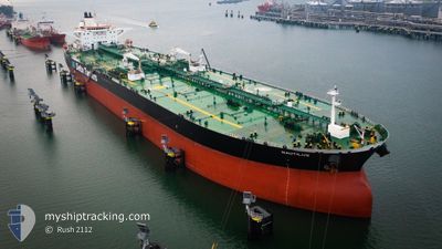
NAUTILUS
Crude Oil Tanker
Current Trip
SUEZ
| Time Travelled | 8 days |
|---|---|
| Remaining Time | --- |
| Distance Travelled | 1167.87 nm |
| Remaining Distance | --- |
| AVG Speed | 9.6 Knop |
| MAX Speed | 17 Knop |
| AVG Wind | 12.1 knots |
| MAX Wind | 25.7 knots |
| MIN Temp | 10.5°C / 50.9°F |
| MAX Temp | 37°C / 98.6°F |
| Djupgående | 16.6 m |
| Position mottagen | 1 d sen |
Current Position
| Longitud | 32.55100° |
|---|---|
| Latitude | 29.86905° |
| Status | Under way using engine |
| Fart | 10.9 Knop |
| Kurs | 172° |
| Område | Gulf of Suez |
| Station | T-AIS |
| Position mottagen | 1 d sen |
Info
Information
The current position of NAUTILUS is in Gulf of Suez with coordinates 29.86905° / 32.55100° as reported on 2024-04-17 16:58 by AIS to our vessel tracker app. The vessel's current speed is 10.9 Knop
The vessel NAUTILUS (IMO: 9298765, MMSI: 240498000) is a Crude Oil Tanker that was built in 2006 ( 18 År gammal ). It's sailing under the flag of [GR] Greece.
In this page you can find informations about the vessels current position, last detected port calls, and current voyage information. If the vessels is not in coverage by AIS you will find the latest position.
The current position of NAUTILUS is detected by our AIS receivers and we are not responsible for the reliability of the data. The last position was recorded while the vessel was in Coverage by the Ais receivers of our vessel tracking app.
The current draught of NAUTILUS as reported by AIS is 16.6 meters
Weather
| Temperature | 24.5°C / 76.1°F |
|---|---|
| Wind Speed | 10 knots |
| Direction | 155° SSE |
| Pressure | 1009.9 hPa |
| Humidity | 60.7 % |
| Cloud Coverage | 1 % |
Featured Company
Last Port Calls
| Port | Arrival | Departure | Time In Port |
|---|---|---|---|
| 2024-04-17 06:26 | 2024-04-17 16:13 | 9 h | |
| 2024-04-07 08:09 | 2024-04-10 19:43 | 3 d | |
| 2024-03-29 11:28 | 2024-04-01 23:33 | 3 d |
Most Visited Ports (Last year)
| Port | Arrivals | |
|---|---|---|
| 2 | ||
| 2 | ||
| 2 | ||
| 1 | ||
| 1 | ||
| 1 |
Events
| Tid | Event | Detaljer | Position / Dest | Information |
|---|---|---|---|---|
| 2024-04-17 17:07 | Status ändrad | Default Under way using engine |
29.84458 / 32.54982
SUEZ
|
Fart: 10.9 kn Kurs: 172° |
| 2024-04-17 16:58 | UTANFÖR täckningsområde |
29.86905 / 32.55100
Gulf of Suez
|
Fart: 10.9 kn Kurs: 172° |
|
| 2024-04-17 16:13 | Byter havsområde | Egyptian part of the Gulf of Suez Egyptian part of the Mediterranean Sea - Eastern Basin |
29.94573 / 32.57750
Gulf of Suez
|
Fart: 4.5 kn Kurs: 212° |
| 2024-04-17 16:13 | AVGÅTT HAMN |
|
29.94573 / 32.57750
SUEZ
|
Fart: 4.6 kn Kurs: 215° |
| 2024-04-17 13:55 | Status ändrad | Under way using engine Default |
30.25998 / 32.50717
[EG] SUEZ CANAL
|
Fart: 8.7 kn Kurs: 107° |
| 2024-04-17 13:51 | Status ändrad | Default Under way using engine |
30.26280 / 32.49692
[EG] SUEZ CANAL
|
Fart: 8.9 kn Kurs: 108° |
| 2024-04-17 13:44 | Status ändrad | Under way using engine Default |
30.26847 / 32.47700
[EG] SUEZ CANAL
|
Fart: 10.3 kn Kurs: 108° |
| 2024-04-17 13:37 | I täckningsområde |
30.26688 / 32.48273
Mediterranean Sea - Eastern Basin
[EG] SUEZ CANAL
|
Fart: 9.3 kn Kurs: 107° |
|
| 2024-04-17 07:28 | Status ändrad | Default Under way using engine |
31.11090 / 32.31098
[EG] SUEZ CANAL
|
Fart: 8.5 kn Kurs: 193° |
| 2024-04-17 07:24 | UTANFÖR täckningsområde |
31.12172 / 32.31418
Mediterranean Sea - Eastern Basin
[EG] SUEZ CANAL
|
Fart: 8.5 kn Kurs: 195° |