
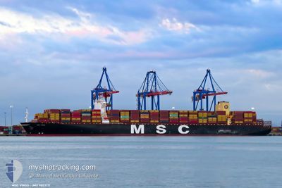
MSC VIRGO
Cargo A
Current Trip
| Trip Time | 10 days |
|---|---|
| Trip Distance | 3865.63 nm |
| AVG Speed | 13.1 Knop |
| MAX Speed | 20.1 Knop |
| Djupgående | 13.7 m |
| AVG Wind | 16 knots |
| MAX Wind | 34.8 knots |
| MIN Temp | 6.1°C / 42.98°F |
| MAX Temp | 30°C / 86°F |
| Position mottagen | 2 m sen |
Current Position
| Longitud | 4.05977° |
|---|---|
| Latitude | 51.95941° |
| Status | Moored |
| Fart | |
| Kurs | 262° |
| Område | North Sea |
| Station | T-AIS |
| Position mottagen | 2 m sen |
Info
Information
The current position of MSC VIRGO is in North Sea with coordinates 51.95941° / 4.05977° as reported on 2024-04-18 06:20 by AIS to our vessel tracker app. The vessel's current speed is 0 Knop and is currently inside the port of MAASVLAKTE - ROTTERDAM.
The vessel MSC VIRGO (IMO: 9857171, MMSI: 255806340) is a Cargo A It's sailing under the flag of [PT] Portugal.
In this page you can find informations about the vessels current position, last detected port calls, and current voyage information. If the vessels is not in coverage by AIS you will find the latest position.
The current position of MSC VIRGO is detected by our AIS receivers and we are not responsible for the reliability of the data. The last position was recorded while the vessel was in Coverage by the Ais receivers of our vessel tracking app.
The current draught of MSC VIRGO as reported by AIS is 13.7 meters
Weather
| Temperature | 8°C / 46.4°F |
|---|---|
| Wind Speed | 9 knots |
| Direction | 18° NNE |
| Pressure | 1019.3 hPa |
| Humidity | 69 % |
| Cloud Coverage | 15 % |
Featured Company
Last Port Calls
| Port | Arrival | Departure | Time In Port |
|---|---|---|---|
| 2024-04-18 01:33 | |||
| 2024-04-06 12:43 | 2024-04-07 13:23 | 1 d | |
| 2024-03-25 03:25 | 2024-03-26 05:25 | 1 d | |
| 2024-02-27 07:35 | 2024-02-28 08:12 | 1 d | |
| 2024-02-23 11:15 | 2024-02-26 01:11 | 2 d | |
| 2024-02-16 01:15 | 2024-02-18 05:43 | 2 d |
Most Visited Ports (Last year)
| Port | Arrivals | |
|---|---|---|
| 4 | ||
| 4 | ||
| 3 | ||
| 3 | ||
| 3 | ||
| 2 |
Last Trips
| Origin | Departure | Destination | Arrival | Distance | |
|---|---|---|---|---|---|
| 2024-04-07 13:23 | 2024-04-18 03:33 | 3865.63 nm | |||
| 2024-03-26 05:25 | 2024-04-06 12:43 | 464.23 nm | |||
| 2024-02-28 13:42 | 2024-03-25 03:25 | 7814.17 nm | |||
| 2024-02-26 06:41 | 2024-02-27 13:05 | 404.81 nm | |||
| 2024-02-18 11:13 | 2024-02-23 16:45 | 1186.67 nm | |||
| 2024-01-17 15:20 | 2024-02-16 06:45 | 10621.96 nm |
Events
| Tid | Event | Detaljer | Position / Dest | Information |
|---|---|---|---|---|
| 2024-04-18 01:53 | Status ändrad | Moored Under way using engine |
51.95968 / 4.05976
[NL] MAASVLAKTE - ROTTERDAM
|
Fart: 0.1 kn Kurs: 260° |
| 2024-04-18 01:48 | STOPPAR förflyttning |
51.95982 / 4.05987
[NL] MAASVLAKTE - ROTTERDAM
|
Fart: 0.3 kn Kurs: 257° |
|
| 2024-04-18 01:33 | ANLÄNDER HAMN |
|
51.96276 / 4.07973
[NL] MAASVLAKTE - ROTTERDAM
|
Fart: 4.1 kn Kurs: 252° |
| 2024-04-17 20:04 | ETA ändrat | 2024/04/17 22:45 2024/04/17 19:00 |
51.90299 / 3.28889
NLRTM
|
Fart: 7 kn Kurs: 75.2° |
| 2024-04-17 17:05 | Byter havsområde | Dutch part of the North Sea Belgian part of the North Sea |
51.79304 / 2.68151
North Sea
NLRTM
|
Fart: 9.1 kn Kurs: 87.2° |
| 2024-04-17 16:17 | Upptäckt i hav | Belgian part of the North Sea |
51.81778 / 2.50220
North Sea
NLRTM
|
Fart: 9 kn Kurs: 103° |
| 2024-04-17 15:36 | STARTAR förflyttning |
51.84438 / 2.37203
NLRTM
|
Fart: 3.1 kn Kurs: 99° |
|
| 2024-04-17 14:36 | STOPPAR förflyttning |
51.87275 / 2.37262
NLRTM
|
Fart: 0.3 kn Kurs: 9° |
|
| 2024-04-17 14:13 | STARTAR förflyttning |
51.86147 / 2.37910
NLRTM
|
Fart: 3.1 kn Kurs: 14° |
|
| 2024-04-17 10:37 | STOPPAR förflyttning |
51.93129 / 2.35558
NLRTM
|
Fart: 0.3 kn Kurs: 328° |