
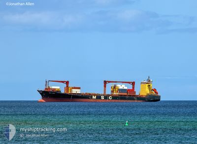
MSC HINA
Container Ship
Current Trip
LUANDA
| Time Travelled | 17 h, 17 mins |
|---|---|
| Remaining Time | --- |
| Distance Travelled | 233.28 nm |
| Remaining Distance | --- |
| AVG Speed | 13.6 Knop |
| MAX Speed | 14.5 Knop |
| AVG Wind | 4.5 knots |
| MAX Wind | 8 knots |
| MIN Temp | 24.4°C / 75.92°F |
| MAX Temp | 27.7°C / 81.86°F |
| Djupgående | 8.5 m |
| Position mottagen | 2025-06-27 09:50 |
Current Position
| Longitud | --- |
|---|---|
| Latitude | --- |
| Status | Under way using engine |
| Fart | 7.6 Knop |
| Kurs | 334.5° |
| Område | Gulf of Guinea |
| Station | T-AIS |
| Position mottagen | 2025-06-27 09:50 |
Info
Information
The current position of MSC HINA is in Gulf of Guinea with coordinates 6.30036° / 3.45969° as reported on 2025-06-27 09:50 by AIS to our vessel tracker app. The vessel's current speed is 7.6 Knop
The vessel MSC HINA (IMO: 9062984, MMSI: 636017056) is a Container Ship that was built in 1994 ( 31 År gammal ). It's sailing under the flag of [LR] Liberia.
In this page you can find informations about the vessels current position, last detected port calls, and current voyage information. If the vessels is not in coverage by AIS you will find the latest position.
The current position of MSC HINA is detected by our AIS receivers and we are not responsible for the reliability of the data. The last position was recorded while the vessel was in Coverage by the Ais receivers of our vessel tracking app.
The current draught of MSC HINA as reported by AIS is 8.5 meters
Weather
| Temperature | 27°C / 80.6°F |
|---|---|
| Wind Speed | 8 knots |
| Direction | 220° SW |
| Pressure | 1012.5 hPa |
| Humidity | 79.4 % |
| Cloud Coverage | 30 % |
Featured Company
Last Port Calls
| Port | Arrival | Departure | Time In Port |
|---|---|---|---|
| 2025-12-07 10:03 | 2025-12-08 07:52 | 21 h | |
| 2025-12-01 18:15 | 2025-12-02 18:55 | 1 d | |
| 2025-11-28 04:25 | 2025-11-29 13:25 | 1 d | |
| 2025-11-05 08:52 | 2025-11-06 22:32 | 1 d | |
| 2025-10-25 00:46 | 2025-11-02 07:14 | 8 d | |
| 2025-10-20 14:52 | 2025-10-21 12:36 | 21 h | |
| 2025-10-14 12:20 | 2025-10-16 02:00 | 1 d | |
| 2025-10-02 03:12 | 2025-10-04 03:56 | 2 d |
Last Trips
| Origin | Departure | Destination | Arrival | Distance | |
|---|---|---|---|---|---|
| 2025-12-02 18:55 | 2025-12-07 10:03 | 635.29 nm | |||
| 2025-11-29 13:25 | 2025-12-01 18:15 | 224.00 nm | |||
| 2025-11-06 22:32 | 2025-11-28 04:25 | 2065.53 nm | |||
| 2025-11-02 07:14 | 2025-11-05 08:52 | 233.23 nm | |||
| 2025-10-21 12:36 | 2025-10-25 00:46 | 218.43 nm | |||
| 2025-10-16 02:00 | 2025-10-20 14:52 | 595.53 nm | |||
| 2025-10-04 03:56 | 2025-10-14 12:20 | 203.98 nm | |||
| 2025-09-23 19:40 | 2025-10-02 03:12 | 201.19 nm |
Events
| Tid | Event | Detaljer | Position / Dest | Information |
|---|---|---|---|---|
| 2025-12-08 07:52 | AVGÅTT HAMN |
|
6.35398 / -10.81905
LUANDA
|
Fart: 7.6 kn Kurs: 302° |
| 2025-12-08 07:49 | STARTAR förflyttning |
6.34941 / -10.81127
[LR] MONROVIA
|
Fart: 7.6 kn Kurs: 302° |
|
| 2025-12-07 10:25 | STOPPAR förflyttning |
6.34278 / -10.79642
[LR] MONROVIA
|
Fart: 0.1 kn Kurs: 203° |
|
| 2025-12-07 10:03 | ANLÄNDER HAMN |
|
6.34803 / -10.80917
[LR] MONROVIA
|
Fart: 6.5 kn Kurs: 127° |
| 2025-12-07 09:22 | STARTAR förflyttning | 3.19 nm, West of MONROVIA |
6.34916 / -10.85735
LUANDA
|
Fart: 4.3 kn Kurs: 302° |
| 2025-12-07 09:00 | STOPPAR förflyttning | 2.94 nm, West of MONROVIA |
6.35135 / -10.85289
LUANDA
|
Fart: 0.3 kn Kurs: 328° |
| 2025-12-07 08:36 | STARTAR förflyttning | 2.4 nm, West of MONROVIA |
6.33414 / -10.84239
LUANDA
|
Fart: 5 kn Kurs: 339° |
| 2025-12-06 08:04 | STOPPAR förflyttning | 2.54 nm, South West of MONROVIA |
6.32978 / -10.84323
LUANDA
|
Fart: 0.1 kn Kurs: 82° |
| 2025-12-04 17:19 | STOPPAR förflyttning | 2.51 nm, South West of MONROVIA |
6.32946 / -10.84255
LUANDA
|
Fart: 0.2 kn Kurs: 64° |
| 2025-12-02 18:55 | AVGÅTT HAMN |
|
4.89956 / -1.72847
LUANDA
|
Fart: 4.9 kn Kurs: 50° |