
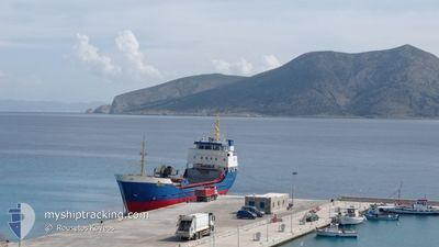
MICHAIL
General Cargo
Current Trip
| Trip Time | 3 h, 6 mins |
|---|---|
| Trip Distance | 26.00 nm |
| AVG Speed | 9 Knop |
| MAX Speed | 9.8 Knop |
| Djupgående | 4.5 m |
| AVG Wind | 11.5 knots |
| MAX Wind | 18.7 knots |
| MIN Temp | 18.6°C / 65.48°F |
| MAX Temp | 19.8°C / 67.64°F |
| Position mottagen | 17 h, 37 m sen |
Current Position
| Longitud | 26.83596° |
|---|---|
| Latitude | 37.10102° |
| Status | Under way using engine |
| Fart | 9.2 Knop |
| Kurs | 326.1° |
| Område | Aegean Sea |
| Station | T-AIS |
| Position mottagen | 17 h, 37 m sen |
Info
Information
The current position of MICHAIL is in Aegean Sea with coordinates 37.10102° / 26.83596° as reported on 2024-04-22 12:58 by AIS to our vessel tracker app. The vessel's current speed is 9.2 Knop and is currently inside the port of LEROS.
The vessel MICHAIL (IMO: 7716488, MMSI: 240193200) is a General Cargo that was built in 1978 ( 46 År gammal ). It's sailing under the flag of [GR] Greece.
In this page you can find informations about the vessels current position, last detected port calls, and current voyage information. If the vessels is not in coverage by AIS you will find the latest position.
The current position of MICHAIL is detected by our AIS receivers and we are not responsible for the reliability of the data. The last position was recorded while the vessel was in Coverage by the Ais receivers of our vessel tracking app.
The current draught of MICHAIL as reported by AIS is 4.5 meters
Weather
| Temperature | 18.8°C / 65.84°F |
|---|---|
| Wind Speed | 23 knots |
| Direction | 121° ESE |
| Pressure | 1013.3 hPa |
| Humidity | 71.1 % |
| Cloud Coverage | 100 % |
Featured Company
Last Port Calls
| Port | Arrival | Departure | Time In Port |
|---|---|---|---|
| 2024-04-22 13:10 | |||
| 2024-04-21 11:56 | 2024-04-22 10:04 | 22 h | |
| 2024-04-21 03:15 | |||
| 2024-04-18 03:45 | 2024-04-18 08:09 | 4 h | |
| 2024-04-15 21:15 | 2024-04-16 08:39 | 11 h | |
| 2024-04-15 08:00 | 2024-04-15 15:15 | 7 h | |
| 2024-04-12 13:15 | 2024-04-15 00:56 | 2 d | |
| 2024-04-11 03:41 | 2024-04-11 10:21 | 6 h | |
| 2024-04-09 15:19 | 2024-04-10 08:32 | 17 h | |
| 2024-04-08 16:10 | 2024-04-09 06:28 | 14 h |
Last Trips
| Origin | Departure | Destination | Arrival | Distance | |
|---|---|---|---|---|---|
| 2024-04-22 13:04 | 2024-04-22 16:10 | 26.00 nm | |||
| 2024-04-21 06:15 | 2024-04-21 14:56 | 25.45 nm | |||
| 2024-04-16 11:39 | 2024-04-18 06:45 | 30.96 nm | |||
| 2024-04-15 18:15 | 2024-04-16 00:15 | 61.04 nm | |||
| 2024-04-15 03:56 | 2024-04-15 11:00 | 61.20 nm | |||
| 2024-04-11 13:21 | 2024-04-12 16:15 | 94.59 nm | |||
| 2024-04-10 11:32 | 2024-04-11 06:41 | 112.87 nm | |||
| 2024-04-09 09:28 | 2024-04-09 18:19 | 26.48 nm | |||
| 2024-04-08 15:24 | 2024-04-08 19:10 | 31.22 nm | |||
| 2024-04-06 16:05 | 2024-04-07 14:07 | 48.29 nm |
Events
| Tid | Event | Detaljer | Position / Dest | Information |
|---|---|---|---|---|
| 2024-04-22 13:10 | ANLÄNDER HAMN |
|
37.13002 / 26.84975
[GR] LEROS
|
Fart: 9.2 kn Kurs: 326.1° |
| 2024-04-22 12:58 | Status ändrad | Under way using engine Default |
37.10102 / 26.83596
KOS
|
Fart: 9 kn Kurs: 274° |
| 2024-04-22 12:58 | UTANFÖR täckningsområde |
37.10102 / 26.83596
Aegean Sea
|
Fart: 9.2 kn Kurs: 326.1° |
|
| 2024-04-22 12:49 | Status ändrad | Default Under way using engine |
37.09203 / 26.85893
KOS
|
Fart: 8.8 kn Kurs: 261.8° |
| 2024-04-22 10:48 | Byter havsområde | Greek part of the Aegean Sea Turkish part of the Aegean Sea |
36.97326 / 27.19189
Aegean Sea
|
Fart: 8.9 kn Kurs: 302.5° |
| 2024-04-22 10:29 | Byter havsområde | Turkish part of the Aegean Sea Greek part of the Aegean Sea |
36.94596 / 27.24185
Aegean Sea
|
Fart: 9.3 kn Kurs: 304.3° |
| 2024-04-22 10:15 | STARTAR förflyttning | 1.98 nm, North of KOS |
36.92619 / 27.28086
KOS
|
Fart: 9.5 kn Kurs: 317.7° |
| 2024-04-22 10:04 | AVGÅTT HAMN |
|
36.92619 / 27.28086
KOS
|
Fart: 0.4 kn Kurs: 511° |
| 2024-04-22 03:26 | I täckningsområde |
36.89861 / 27.28995
Aegean Sea
[GR] KOS
|
Fart: 0.1 kn Kurs: 60.7° |
|
| 2024-04-22 02:20 | UTANFÖR täckningsområde |
36.89859 / 27.28996
Aegean Sea
[GR] KOS
|
Fart: 0.1 kn Kurs: 109.3° |