
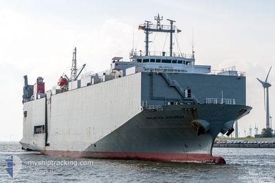
MALACCA HIGHWAY
Vehicles Carrier
Current Trip
| Time Travelled | 4 days |
|---|---|
| Remaining Time | 9 h, 44 mins |
| Distance Travelled | 1036.81 nm |
| Remaining Distance | 145.84 nm |
| AVG Speed | 13.4 Knop |
| MAX Speed | 19.2 Knop |
| AVG Wind | 12.9 knots |
| MAX Wind | 29 knots |
| MIN Temp | 2.8°C / 37.04°F |
| MAX Temp | 12.4°C / 54.32°F |
| Djupgående | 5.5 m |
| Position mottagen | 12 h, 28 m sen |
Current Position
| Longitud | -5.65107° |
|---|---|
| Latitude | 48.14880° |
| Status | Under way using engine |
| Fart | 14.6 Knop |
| Kurs | 151.3° |
| Område | Celtic Sea |
| Station | T-AIS |
| Position mottagen | 12 h, 28 m sen |
Info
Information
The current position of MALACCA HIGHWAY is in Celtic Sea with coordinates 48.14880° / -5.65107° as reported on 2024-04-24 02:24 by AIS to our vessel tracker app. The vessel's current speed is 14.6 Knop and is heading at the port of PASAJES. The estimated time of arrival as calculated by MyShipTracking vessel tracking app is 2024-04-25 00:36 LT
The vessel MALACCA HIGHWAY (IMO: 9235414, MMSI: 355351000) is a Vehicles Carrier that was built in 2001 ( 23 År gammal ). It's sailing under the flag of [PA] Panama.
In this page you can find informations about the vessels current position, last detected port calls, and current voyage information. If the vessels is not in coverage by AIS you will find the latest position.
The current position of MALACCA HIGHWAY is detected by our AIS receivers and we are not responsible for the reliability of the data. The last position was recorded while the vessel was in Coverage by the Ais receivers of our vessel tracking app.
The current draught of MALACCA HIGHWAY as reported by AIS is 5.5 meters
Weather
| Temperature | 12.3°C / 54.14°F |
|---|---|
| Wind Speed | 15 knots |
| Direction | 304° NW |
| Pressure | 1018.7 hPa |
| Humidity | 74.7 % |
| Cloud Coverage | 84 % |
Featured Company
Last Port Calls
| Port | Arrival | Departure | Time In Port |
|---|---|---|---|
| 2024-04-18 16:23 | 2024-04-20 02:19 | 1 d | |
| 2024-04-17 15:06 | 2024-04-18 01:59 | 10 h | |
| 2024-04-14 04:04 | 2024-04-14 13:04 | 8 h | |
| 2024-04-06 09:01 | 2024-04-08 13:01 | 2 d | |
| 2024-04-04 16:39 | 2024-04-05 06:34 | 13 h | |
| 2024-04-02 20:53 | 2024-04-03 14:19 | 17 h | |
| 2024-04-01 15:17 | 2024-04-02 06:44 | 15 h | |
| 2024-03-27 13:00 | 2024-03-29 16:55 | 2 d | |
| 2024-03-24 20:20 | 2024-03-25 11:55 | 15 h | |
| 2024-03-22 09:27 | 2024-03-23 00:07 | 14 h |
Last Trips
| Origin | Departure | Destination | Arrival | Distance | |
|---|---|---|---|---|---|
| 2024-04-18 03:59 | 2024-04-18 18:23 | 186.21 nm | |||
| 2024-04-14 15:04 | 2024-04-17 17:06 | 1072.21 nm | |||
| 2024-04-08 15:01 | 2024-04-14 06:04 | 1180.63 nm | |||
| 2024-04-05 07:34 | 2024-04-06 11:01 | 336.49 nm | |||
| 2024-04-03 16:19 | 2024-04-04 17:39 | 342.80 nm | |||
| 2024-04-02 08:44 | 2024-04-02 22:53 | 186.30 nm | |||
| 2024-03-29 17:55 | 2024-04-01 17:17 | 1075.11 nm | |||
| 2024-03-25 11:55 | 2024-03-27 14:00 | 762.06 nm | |||
| 2024-03-23 01:07 | 2024-03-24 20:20 | 313.00 nm | |||
| 2024-03-20 05:24 | 2024-03-22 10:27 | 549.59 nm |
Events
| Tid | Event | Detaljer | Position / Dest | Information |
|---|---|---|---|---|
| 2024-04-24 02:40 | Status ändrad | Default Under way using engine |
48.09184 / -5.60524
ESPAS
|
Fart: 14.6 kn Kurs: 151.3° |
| 2024-04-24 02:24 | UTANFÖR täckningsområde |
48.14880 / -5.65107
Celtic Sea
ESPAS
|
Fart: 14.6 kn Kurs: 151.3° |
|
| 2024-04-24 02:11 | Status ändrad | Under way using engine Default |
48.19427 / -5.68845
ESPAS
|
Fart: 14 kn Kurs: 151° |
| 2024-04-24 01:50 | Status ändrad | Default Under way using engine |
48.26833 / -5.74833
ESPAS
|
Fart: 14.4 kn Kurs: 152.8° |
| 2024-04-24 01:41 | Status ändrad | Under way using engine Default |
48.30089 / -5.77442
ESPAS
|
Fart: 14 kn Kurs: 151° |
| 2024-04-24 00:47 | Status ändrad | Default Under way using engine |
48.49500 / -5.92500
ESPAS
|
Fart: 14.8 kn Kurs: 163.4° |
| 2024-04-24 00:37 | Status ändrad | Under way using engine Default |
48.53283 / -5.94473
ESPAS
|
Fart: 14 kn Kurs: 164° |
| 2024-04-24 00:26 | Status ändrad | Default Under way using engine |
48.57706 / -5.96306
ESPAS
|
Fart: 14.9 kn Kurs: 173.6° |
| 2024-04-24 00:19 | Byter havsområde | French part of the Celtic Sea French part of the English Channel |
48.60720 / -5.97403
Celtic Sea
ESPAS
|
Fart: 14.9 kn Kurs: 173.6° |
| 2024-04-24 00:18 | Status ändrad | Under way using engine Default |
48.61095 / -5.97450
ESPAS
|
Fart: 15 kn Kurs: 188° |