
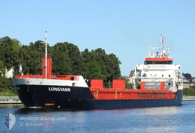
LONGVANN
General Cargo
Current Trip
| Trip Time | 5 days |
|---|---|
| Trip Distance | 1416.47 nm |
| AVG Speed | 10.7 Knop |
| MAX Speed | 13.1 Knop |
| Djupgående | 6.5 m |
| AVG Wind | 15.1 knots |
| MAX Wind | 33 knots |
| MIN Temp | 3.3°C / 37.94°F |
| MAX Temp | 9.7°C / 49.46°F |
| Position mottagen | 1 m sen |
Current Position
| Longitud | -5.90428° |
|---|---|
| Latitude | 54.61693° |
| Status | Under way using engine |
| Fart | |
| Kurs | --- |
| Område | Inner Seas off the West Coast of Scotland |
| Station | T-AIS |
| Position mottagen | 1 m sen |
Info
Information
The current position of LONGVANN is in Inner Seas off the West Coast of Scotland with coordinates 54.61693° / -5.90428° as reported on 2024-04-19 20:59 by AIS to our vessel tracker app. The vessel's current speed is 0 Knop and is currently inside the port of BELFAST.
The vessel LONGVANN (IMO: 9548304, MMSI: 246670000) is a General Cargo that was built in 2011 ( 13 År gammal ). It's sailing under the flag of [NL] Netherlands.
In this page you can find informations about the vessels current position, last detected port calls, and current voyage information. If the vessels is not in coverage by AIS you will find the latest position.
The current position of LONGVANN is detected by our AIS receivers and we are not responsible for the reliability of the data. The last position was recorded while the vessel was in Coverage by the Ais receivers of our vessel tracking app.
The current draught of LONGVANN as reported by AIS is 6.5 meters
Weather
| Temperature | 4.1°C / 39.38°F |
|---|---|
| Wind Speed | 5 knots |
| Direction | 319° NW |
| Pressure | 1026.7 hPa |
| Humidity | 90.9 % |
| Cloud Coverage | 13 % |
Featured Company
Last Port Calls
| Port | Arrival | Departure | Time In Port |
|---|---|---|---|
| 2024-04-19 16:37 | |||
| 2024-04-13 11:59 | 2024-04-14 00:21 | 12 h | |
| 2024-04-02 16:51 | 2024-04-03 18:08 | 1 d | |
| 2024-03-27 09:08 | 2024-03-30 04:18 | 2 d | |
| 2024-03-22 06:56 | 2024-03-23 09:17 | 1 d | |
| 2024-03-19 23:43 | 2024-03-20 18:21 | 18 h | |
| 2024-03-12 21:18 | 2024-03-13 16:50 | 19 h | |
| 2024-03-10 06:12 | 2024-03-11 04:34 | 22 h | |
| 2024-03-06 15:30 | 2024-03-08 08:02 | 1 d | |
| 2024-03-03 12:45 | 2024-03-04 04:25 | 15 h |
Most Visited Ports (Last year)
| Port | Arrivals | |
|---|---|---|
| 14 | ||
| 8 | ||
| 6 | ||
| 5 | ||
| 4 | ||
| 3 |
Last Trips
| Origin | Departure | Destination | Arrival | Distance | |
|---|---|---|---|---|---|
| 2024-04-14 03:21 | 2024-04-19 17:37 | 1416.47 nm | |||
| 2024-04-03 20:08 | 2024-04-13 14:59 | 1880.53 nm | |||
| 2024-03-30 05:18 | 2024-04-02 18:51 | 794.28 nm | |||
| 2024-03-23 10:17 | 2024-03-27 10:08 | 749.68 nm | |||
| 2024-03-20 19:21 | 2024-03-22 07:56 | 398.94 nm | |||
| 2024-03-13 17:50 | 2024-03-20 00:43 | 1162.96 nm | |||
| 2024-03-11 06:34 | 2024-03-12 22:18 | 427.66 nm | |||
| 2024-03-08 09:02 | 2024-03-10 08:12 | 452.66 nm | |||
| 2024-03-04 06:25 | 2024-03-06 16:30 | 555.10 nm | |||
| 2024-03-01 15:05 | 2024-03-03 14:45 | 543.16 nm |
Events
| Tid | Event | Detaljer | Position / Dest | Information |
|---|---|---|---|---|
| 2024-04-19 17:06 | STOPPAR förflyttning |
54.61700 / -5.90417
[GB] BELFAST
|
Fart: Kurs: 511° |
|
| 2024-04-19 16:37 | ANLÄNDER HAMN |
|
54.64423 / -5.86660
[GB] BELFAST
|
Fart: 9.5 kn Kurs: 215° |
| 2024-04-19 15:11 | Status ändrad | Under way using engine Default |
54.82775 / -5.65717
BELFAST_
|
Fart: 10.7 kn Kurs: 179° |
| 2024-04-19 14:56 | I täckningsområde |
54.82128 / -5.65758
Inner Seas off the West Coast of Scotland
BELFAST_
|
Fart: 11.8 kn Kurs: 182° |
|
| 2024-04-19 12:31 | UTANFÖR täckningsområde |
55.22927 / -5.98872
Inner Seas off the West Coast of Scotland
BELFAST_
|
Fart: 8.7 kn Kurs: 145° |
|
| 2024-04-19 07:19 | Upptäckt i hav | United Kingdom part of the Inner Seas off the West Coast of Scotland |
55.93157 / -6.93265
Inner Seas off the West Coast of Scotland
BELFAST_
|
Fart: 11.6 kn Kurs: 145° |
| 2024-04-19 07:19 | I täckningsområde |
55.93157 / -6.93265
Inner Seas off the West Coast of Scotland
BELFAST_
|
Fart: 11.6 kn Kurs: 145° |
|
| 2024-04-18 11:36 | Status ändrad | Default Under way using engine |
58.69313 / -4.37260
BELFAST_
|
Fart: 9.9 kn Kurs: 310° |
| 2024-04-18 11:26 | UTANFÖR täckningsområde |
58.69475 / -4.31910
North Atlantic Ocean
BELFAST_
|
Fart: 9.9 kn Kurs: 310° |
|
| 2024-04-18 08:47 | Upptäckt i hav | United Kingdom part of the North Atlantic Ocean |
58.70645 / -3.42565
North Atlantic Ocean
BELFAST_
|
Fart: 10.4 kn Kurs: 265° |