
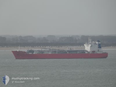
KOKSIJDE
Tanker
Current Trip
| Time Travelled | 4 days |
|---|---|
| Remaining Time | --- |
| Distance Travelled | 1214.69 nm |
| Remaining Distance | --- |
| AVG Speed | 11.9 Knop |
| MAX Speed | 16.2 Knop |
| AVG Wind | 11.9 knots |
| MAX Wind | 30 knots |
| MIN Temp | 4.8°C / 40.64°F |
| MAX Temp | 12.5°C / 54.5°F |
| Djupgående | 6.6 m |
| Position mottagen | 1 m sen |
Current Position
| Longitud | 3.86123° |
|---|---|
| Latitude | 60.79318° |
| Status | Under way using engine |
| Fart | 2 Knop |
| Kurs | 83° |
| Område | North Sea |
| Station | T-AIS |
| Position mottagen | 1 m sen |
Info
Information
The current position of KOKSIJDE is in North Sea with coordinates 60.79318° / 3.86123° as reported on 2024-04-23 16:33 by AIS to our vessel tracker app. The vessel's current speed is 2 Knop and is heading at the port of STURE. The estimated time of arrival as calculated by MyShipTracking vessel tracking app is 2024-04-23 10:00 LT
The vessel KOKSIJDE (IMO: 9719305, MMSI: 205743000) is a Tanker It's sailing under the flag of [BE] Belgium.
In this page you can find informations about the vessels current position, last detected port calls, and current voyage information. If the vessels is not in coverage by AIS you will find the latest position.
The current position of KOKSIJDE is detected by our AIS receivers and we are not responsible for the reliability of the data. The last position was recorded while the vessel was in Coverage by the Ais receivers of our vessel tracking app.
The current draught of KOKSIJDE as reported by AIS is 6.6 meters
Weather
| Temperature | 5°C / 41°F |
|---|---|
| Wind Speed | 28 knots |
| Direction | 3° N |
| Pressure | 1017.3 hPa |
| Humidity | 75.7 % |
| Cloud Coverage | 7 % |
Featured Company
Last Port Calls
| Port | Arrival | Departure | Time In Port |
|---|---|---|---|
| 2024-04-17 00:11 | 2024-04-19 09:01 | 2 d | |
| 2024-04-13 18:03 | 2024-04-14 19:24 | 1 d | |
| 2024-04-08 21:27 | 2024-04-09 13:52 | 16 h | |
| 2024-04-05 19:00 | 2024-04-06 22:57 | 1 d | |
| 2024-04-01 11:26 | 2024-04-03 11:55 | 2 d | |
| 2024-03-29 17:09 | 2024-03-30 14:55 | 21 h | |
| 2024-02-18 03:29 | 2024-02-21 16:32 | 3 d |
Last Trips
| Origin | Departure | Destination | Arrival | Distance | |
|---|---|---|---|---|---|
| 2024-04-14 21:24 | 2024-04-17 02:11 | 39.36 nm | |||
| 2024-04-09 15:52 | 2024-04-13 20:03 | 639.24 nm | |||
| 2024-04-06 23:57 | 2024-04-08 23:27 | 453.24 nm | |||
| 2024-04-03 13:55 | 2024-04-05 20:00 | 471.38 nm | |||
| 2024-03-30 15:55 | 2024-04-01 13:26 | 607.23 nm | |||
| 2024-02-21 19:32 | 2024-03-29 18:09 | 9516.70 nm | |||
| 2024-01-28 14:16 | 2024-02-18 06:29 | 4826.96 nm |
Events
| Tid | Event | Detaljer | Position / Dest | Information |
|---|---|---|---|---|
| 2024-04-23 07:07 | Upptäckt i hav | Norwegian part of the North Sea |
60.19006 / 2.70675
North Sea
FR DON > NO STU
|
Fart: 13.4 kn Kurs: 56.5° |
| 2024-04-23 07:07 | Status ändrad | Under way using engine Default |
60.19006 / 2.70675
FR DON > NO STU
|
Fart: 13 kn Kurs: 66° |
| 2024-04-23 06:58 | I täckningsområde |
60.19006 / 2.70675
North Sea
FR DON > NO STU
|
Fart: 13.4 kn Kurs: 56.5° |
|
| 2024-04-22 11:14 | Status ändrad | Default Under way using engine |
59.25116 / -3.79619
FR DON > NO STU
|
Fart: 11.8 kn Kurs: 53.8° |
| 2024-04-22 11:09 | UTANFÖR täckningsområde |
59.23941 / -3.82349
North Atlantic Ocean
FR DON > NO STU
|
Fart: 11.8 kn Kurs: 53.8° |
|
| 2024-04-22 09:51 | Status ändrad | Under way using engine Default |
59.07400 / -4.20437
FR DON > NO STU
|
Fart: 12 kn Kurs: 53° |
| 2024-04-22 09:50 | Status ändrad | Default Under way using engine |
59.07329 / -4.20601
FR DON > NO STU
|
Fart: 12 kn Kurs: 55.3° |
| 2024-04-22 08:37 | ETA ändrat | 2024/04/23 10:00 2024/04/23 10:15 |
58.91340 / -4.57423
FR DON > NO STU
|
Fart: 12.5 kn Kurs: 47.2° |
| 2024-04-22 08:17 | Byter havsområde | United Kingdom part of the North Atlantic Ocean United Kingdom part of the Inner Seas off the West Coast of Scotland |
58.86856 / -4.67834
North Atlantic Ocean
FR DON > NO STU
|
Fart: 13 kn Kurs: 49.1° |
| 2024-04-22 08:14 | Status ändrad | Under way using engine Default |
58.86295 / -4.69041
FR DON > NO STU
|
Fart: 13.1 kn Kurs: 51° |