
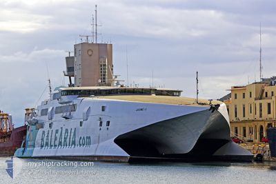
JAUME II
High speed craft
Current Trip
| Time Travelled | 2 h, 40 mins |
|---|---|
| Remaining Time | -1 mins |
| Distance Travelled | 74.93 nm |
| Remaining Distance | 9.47 nm |
| AVG Speed | 28 Knop |
| MAX Speed | 31.6 Knop |
| AVG Wind | 5.2 knots |
| MAX Wind | 6 knots |
| MIN Temp | 24.3°C / 75.74°F |
| MAX Temp | 25.1°C / 77.18°F |
| Djupgående | 3.4 m |
| Position mottagen | Nu |
Current Position
| Longitud | -78.79932° |
|---|---|
| Latitude | 26.50394° |
| Status | Under way using engine |
| Fart | 12.1 Knop |
| Kurs | 61.2° |
| Område | North Atlantic Ocean |
| Station | T-AIS |
| Position mottagen | Nu |
Info
Information
The current position of JAUME II is in North Atlantic Ocean with coordinates 26.50394° / -78.79932° as reported on 2024-04-20 16:05 by AIS to our vessel tracker app. The vessel's current speed is 12.1 Knop and is heading at the port of FREEPORT (BS). The estimated time of arrival as calculated by MyShipTracking vessel tracking app is 2024-04-20 16:05 LT
The vessel JAUME II (IMO: 9116113, MMSI: 209513000) is a High speed craft that was built in 1996 ( 28 År gammal ). It's sailing under the flag of [CY] Cyprus.
In this page you can find informations about the vessels current position, last detected port calls, and current voyage information. If the vessels is not in coverage by AIS you will find the latest position.
The current position of JAUME II is detected by our AIS receivers and we are not responsible for the reliability of the data. The last position was recorded while the vessel was in Coverage by the Ais receivers of our vessel tracking app.
The current draught of JAUME II as reported by AIS is 3.4 meters
Weather
| Temperature | 24.4°C / 75.92°F |
|---|---|
| Wind Speed | 6 knots |
| Direction | 179° S |
| Pressure | 1019.9 hPa |
| Humidity | 68 % |
| Cloud Coverage | --- |
Featured Company
Last Port Calls
| Port | Arrival | Departure | Time In Port |
|---|---|---|---|
| 2024-04-20 04:06 | 2024-04-20 13:26 | 9 h | |
| 2024-04-19 23:49 | 2024-04-20 04:02 | 4 h | |
| 2024-04-17 23:41 | 2024-04-19 13:04 | 1 d | |
| 2024-04-17 00:49 | 2024-04-17 13:22 | 12 h | |
| 2024-04-16 15:52 | 2024-04-16 22:14 | 6 h | |
| 2024-04-15 00:10 | 2024-04-16 13:06 | 1 d | |
| 2024-04-14 00:58 | 2024-04-14 13:04 | 12 h | |
| 2024-04-13 16:00 | 2024-04-13 22:24 | 6 h | |
| 2024-04-12 23:54 | 2024-04-13 12:58 | 13 h | |
| 2024-04-10 23:33 | 2024-04-12 13:07 | 1 d |
Most Visited Ports (Last year)
| Port | Arrivals | |
|---|---|---|
| 232 | ||
| 97 | ||
| 13 | ||
| 1 |
Last Trips
| Origin | Departure | Destination | Arrival | Distance | |
|---|---|---|---|---|---|
| 2024-04-20 00:02 | 2024-04-20 00:06 | 0.27 nm | |||
| 2024-04-19 09:04 | 2024-04-19 19:49 | 99.30 nm | |||
| 2024-04-17 09:22 | 2024-04-17 19:41 | 99.10 nm | |||
| 2024-04-16 18:14 | 2024-04-16 20:49 | 77.02 nm | |||
| 2024-04-16 09:06 | 2024-04-16 11:52 | 76.92 nm | |||
| 2024-04-14 09:04 | 2024-04-14 20:10 | 98.20 nm | |||
| 2024-04-13 18:24 | 2024-04-13 20:58 | 76.86 nm | |||
| 2024-04-13 08:58 | 2024-04-13 12:00 | 76.78 nm | |||
| 2024-04-12 09:07 | 2024-04-12 19:54 | 99.17 nm | |||
| 2024-04-10 08:54 | 2024-04-10 19:33 | 99.78 nm |
Events
| Tid | Event | Detaljer | Position / Dest | Information |
|---|---|---|---|---|
| 2024-04-20 15:28 | Status ändrad | Under way using engine Default |
26.39775 / -79.09442
BSFPO
|
Fart: 30.8 kn Kurs: 71° |
| 2024-04-20 14:42 | Status ändrad | Default Under way using engine |
26.27398 / -79.51228
BSFPO
|
Fart: 30.9 kn Kurs: 69.4° |
| 2024-04-20 14:38 | Byter havsområde | Bahamas part of the North Atlantic Ocean United States part of the North Atlantic Ocean |
26.26454 / -79.54599
North Atlantic Ocean
BSFPO
|
Fart: 30.9 kn Kurs: 69.4° |
| 2024-04-20 13:26 | AVGÅTT HAMN |
|
26.08719 / -80.11363
BSFPO
|
Fart: 6.6 kn Kurs: 349° |
| 2024-04-20 13:23 | STARTAR förflyttning |
26.08145 / -80.11386
[US] FORT LAUDERDALE
|
Fart: 6.3 kn Kurs: 11° |
|
| 2024-04-20 04:06 | STOPPAR förflyttning |
26.07989 / -80.11507
[US] FORT LAUDERDALE
|
Fart: 0.2 kn Kurs: 185° |
|
| 2024-04-20 04:06 | ANLÄNDER HAMN |
|
26.07989 / -80.11505
[US] FORT LAUDERDALE
|
Fart: 0.8 kn Kurs: 184° |
| 2024-04-20 04:02 | AVGÅTT HAMN |
|
26.08425 / -80.11419
BSFPO
|
Fart: 5 kn Kurs: 186° |
| 2024-04-20 03:57 | STARTAR förflyttning |
26.08998 / -80.11653
[US] PORT EVERGLADES
|
Fart: 9.3 kn Kurs: 6° |
|
| 2024-04-20 00:19 | Destination ändrad | BSFPO USPEF |
26.08805 / -80.11623
[US] PORT EVERGLADES
|
Fart: Kurs: 357° |