
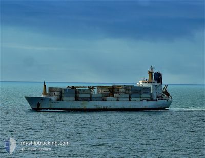
ITALIA STREAM
Reefer
Current Trip
| Time Travelled | 11 days |
|---|---|
| Remaining Time | 5 days |
| Distance Travelled | 4123.03 nm |
| Remaining Distance | 1995.93 nm |
| AVG Speed | 15.4 Knop |
| MAX Speed | 18.9 Knop |
| AVG Wind | 13.5 knots |
| MAX Wind | 28 knots |
| MIN Temp | 10.2°C / 50.36°F |
| MAX Temp | 29°C / 84.2°F |
| Djupgående | 7.2 m |
| Position mottagen | 3 d sen |
Current Position
| Longitud | -18.28013° |
|---|---|
| Latitude | 10.86319° |
| Status | Under way using engine |
| Fart | 16.7 Knop |
| Kurs | 139° |
| Område | North Atlantic Ocean |
| Station | T-AIS |
| Position mottagen | 3 d sen |
Info
Information
The current position of ITALIA STREAM is in North Atlantic Ocean with coordinates 10.86319° / -18.28013° as reported on 2024-04-20 23:35 by AIS to our vessel tracker app. The vessel's current speed is 16.7 Knop and is heading at the port of CAPE TOWN. The estimated time of arrival as calculated by MyShipTracking vessel tracking app is 2024-04-30 05:30 LT
The vessel ITALIA STREAM (IMO: 9030137, MMSI: 308438000) is a Reefer that was built in 1992 ( 32 År gammal ). It's sailing under the flag of [BS] Bahamas.
In this page you can find informations about the vessels current position, last detected port calls, and current voyage information. If the vessels is not in coverage by AIS you will find the latest position.
The current position of ITALIA STREAM is detected by our AIS receivers and we are not responsible for the reliability of the data. The last position was recorded while the vessel was in Coverage by the Ais receivers of our vessel tracking app.
The current draught of ITALIA STREAM as reported by AIS is 7.2 meters
Weather
| Temperature | 27.2°C / 80.96°F |
|---|---|
| Wind Speed | 19 knots |
| Direction | 140° SE |
| Pressure | 1010.1 hPa |
| Humidity | 73.8 % |
| Cloud Coverage | 28 % |
Featured Company
Last Port Calls
| Port | Arrival | Departure | Time In Port |
|---|---|---|---|
| 2024-04-13 09:03 | 2024-04-13 10:58 | 1 h | |
| 2024-04-12 07:05 | 2024-04-12 23:35 | 16 h | |
| 2024-04-05 18:10 | |||
| 2024-03-03 13:58 | 2024-03-10 16:34 | 7 d | |
| 2024-02-28 07:55 | 2024-03-03 13:36 | 4 d | |
| 2024-02-05 06:48 | 2024-02-10 01:32 | 4 d |
Most Visited Ports (Last year)
| Port | Arrivals | |
|---|---|---|
| 7 | ||
| 5 | ||
| 5 | ||
| 2 | ||
| 2 | ||
| 2 |
Last Trips
| Origin | Departure | Destination | Arrival | Distance | |
|---|---|---|---|---|---|
| 2024-04-13 01:35 | 2024-04-13 10:03 | 101.16 nm | |||
| 2024-04-05 20:10 | 2024-04-12 09:05 | 137.36 nm | |||
| 2024-03-03 15:36 | 2024-03-03 15:58 | 3.12 nm | |||
| 2024-02-09 20:32 | 2024-02-28 09:55 | 6928.08 nm | |||
| 2024-01-22 20:50 | 2024-02-05 01:48 | 3799.56 nm |
Events
| Tid | Event | Detaljer | Position / Dest | Information |
|---|---|---|---|---|
| 2024-04-20 23:42 | Status ändrad | Default Under way using engine |
10.83731 / -18.25925
CAPE TOWN
|
Fart: 16.7 kn Kurs: 139° |
| 2024-04-20 23:35 | Status ändrad | Under way using engine Default |
10.86319 / -18.28013
CAPE TOWN
|
Fart: 16.8 kn Kurs: 141° |
| 2024-04-20 23:35 | UTANFÖR täckningsområde |
10.86319 / -18.28013
North Atlantic Ocean
CAPE TOWN
|
Fart: 16.7 kn Kurs: 139° |
|
| 2024-04-20 22:54 | Status ändrad | Default Under way using engine |
11.01243 / -18.40203
CAPE TOWN
|
Fart: 16.5 kn Kurs: 141.8° |
| 2024-04-20 21:47 | Byter havsområde | Guinea Bissau part of the North Atlantic Ocean Senegalese part of the North Atlantic Ocean |
11.25857 / -18.58796
North Atlantic Ocean
CAPE TOWN
|
Fart: 15.8 kn Kurs: 166.8° |
| 2024-04-20 21:47 | Status ändrad | Under way using engine Default |
11.25857 / -18.58796
CAPE TOWN
|
Fart: 16.3 kn Kurs: 181° |
| 2024-04-20 21:46 | Status ändrad | Default Under way using engine |
11.26292 / -18.58877
CAPE TOWN
|
Fart: 16.2 kn Kurs: 179.7° |
| 2024-04-20 20:38 | Status ändrad | Under way using engine Default |
11.57509 / -18.58728
CAPE TOWN
|
Fart: 16.4 kn Kurs: 179° |
| 2024-04-20 20:26 | I täckningsområde |
11.57509 / -18.58728
North Atlantic Ocean
CAPE TOWN
|
Fart: 16.4 kn Kurs: 179.9° |
|
| 2024-04-20 10:46 | UTANFÖR täckningsområde |
14.22444 / -18.58012
North Atlantic Ocean
CAPE TOWN
|
Fart: 15.7 kn Kurs: 178.8° |