
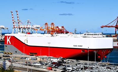
IGUAZU HIGHWAY
Cargo
Current Trip
| Time Travelled | 14 days |
|---|---|
| Remaining Time | --- |
| Distance Travelled | 5751.49 nm |
| Remaining Distance | --- |
| AVG Speed | 15.8 Knop |
| MAX Speed | 20 Knop |
| AVG Wind | 10.9 knots |
| MAX Wind | 23 knots |
| MIN Temp | 17.1°C / 62.78°F |
| MAX Temp | 30.2°C / 86.36°F |
| Djupgående | 9.8 m |
| Position mottagen | 6 h, 35 m sen |
Current Position
| Longitud | 17.93881° |
|---|---|
| Latitude | -34.34155° |
| Status | Under way using engine |
| Fart | 16.7 Knop |
| Kurs | 313.4° |
| Område | South Atlantic Ocean |
| Station | T-AIS |
| Position mottagen | 6 h, 35 m sen |
Info
Information
The current position of IGUAZU HIGHWAY is in South Atlantic Ocean with coordinates -34.34155° / 17.93881° as reported on 2024-04-25 07:51 by AIS to our vessel tracker app. The vessel's current speed is 16.7 Knop and is heading at the port of DERINCE. The estimated time of arrival as calculated by MyShipTracking vessel tracking app is 2024-05-13 18:00 LT
The vessel IGUAZU HIGHWAY (IMO: 9827243, MMSI: 353706000) is a Cargo It's sailing under the flag of [PA] Panama.
In this page you can find informations about the vessels current position, last detected port calls, and current voyage information. If the vessels is not in coverage by AIS you will find the latest position.
The current position of IGUAZU HIGHWAY is detected by our AIS receivers and we are not responsible for the reliability of the data. The last position was recorded while the vessel was in Coverage by the Ais receivers of our vessel tracking app.
The current draught of IGUAZU HIGHWAY as reported by AIS is 9.8 meters
Weather
| Temperature | 18.2°C / 64.76°F |
|---|---|
| Wind Speed | 16 knots |
| Direction | 163° SSE |
| Pressure | 1020.6 hPa |
| Humidity | 86.9 % |
| Cloud Coverage | 100 % |
Featured Company
Last Port Calls
| Port | Arrival | Departure | Time In Port |
|---|---|---|---|
| 2024-04-10 02:34 | 2024-04-10 15:51 | 13 h | |
| 2024-04-10 01:56 | 2024-04-10 02:10 | 13 m | |
| 2024-04-01 21:39 | 2024-04-02 09:15 | 11 h | |
| 2024-03-31 23:29 | 2024-04-01 08:19 | 8 h | |
| 2024-03-30 09:04 | 2024-03-31 07:13 | 22 h | |
| 2024-03-29 20:57 | 2024-03-30 08:24 | 11 h | |
| 2024-03-28 08:14 | 2024-03-28 16:44 | 8 h | |
| 2024-03-19 05:46 | 2024-03-19 16:29 | 10 h | |
| 2024-03-15 05:28 | 2024-03-15 13:46 | 8 h | |
| 2024-03-11 09:35 | 2024-03-12 02:45 | 17 h |
Last Trips
| Origin | Departure | Destination | Arrival | Distance | |
|---|---|---|---|---|---|
| 2024-04-10 10:10 | 2024-04-10 10:34 | 1.26 nm | |||
| 2024-04-02 18:15 | 2024-04-10 09:56 | 2825.73 nm | |||
| 2024-04-01 17:19 | 2024-04-02 06:39 | 125.05 nm | |||
| 2024-03-31 16:13 | 2024-04-01 08:29 | 221.76 nm | |||
| 2024-03-30 17:24 | 2024-03-30 18:04 | 7.01 nm | |||
| 2024-03-29 01:44 | 2024-03-30 05:57 | 260.21 nm | |||
| 2024-03-20 00:29 | 2024-03-28 17:14 | 2982.09 nm | |||
| 2024-03-15 19:16 | 2024-03-19 13:46 | 1464.22 nm | |||
| 2024-03-12 08:15 | 2024-03-15 10:58 | 1381.96 nm | |||
| 2024-03-08 10:15 | 2024-03-11 15:05 | 1343.48 nm |
Events
| Tid | Event | Detaljer | Position / Dest | Information |
|---|---|---|---|---|
| 2024-04-25 07:59 | Status ändrad | Default Under way using engine |
-34.31673 / 17.90709
SGSIN>TRDRC
|
Fart: 16.7 kn Kurs: 313.4° |
| 2024-04-25 07:51 | UTANFÖR täckningsområde |
-34.34155 / 17.93881
South Atlantic Ocean
SGSIN>TRDRC
|
Fart: 16.7 kn Kurs: 313.4° |
|
| 2024-04-25 07:44 | Status ändrad | Under way using engine Default |
-34.36424 / 17.96762
SGSIN>TRDRC
|
Fart: 16.9 kn Kurs: 314° |
| 2024-04-25 07:30 | Status ändrad | Default Under way using engine |
-34.40989 / 18.02573
SGSIN>TRDRC
|
Fart: 17.2 kn Kurs: 313.5° |
| 2024-04-25 05:28 | Status ändrad | Under way using engine Default |
-34.72950 / 18.58854
SGSIN>TRDRC
|
Fart: 16.4 kn Kurs: 292° |
| 2024-04-25 05:15 | I täckningsområde |
-34.72812 / 18.58440
South Atlantic Ocean
SGSIN>TRDRC
|
Fart: 16.5 kn Kurs: 291.6° |
|
| 2024-04-25 04:07 | Status ändrad | Default Under way using engine |
-34.86335 / 19.00762
SGSIN>TRDRC
|
Fart: 16.3 kn Kurs: 288.4° |
| 2024-04-25 03:52 | UTANFÖR täckningsområde |
-34.88326 / 19.08585
South Atlantic Ocean
SGSIN>TRDRC
|
Fart: 16.3 kn Kurs: 288.4° |
|
| 2024-04-25 03:47 | Byter havsområde | South African part of the South Atlantic Ocean R�union part of the Indian Ocean |
-34.89010 / 19.11251
South Atlantic Ocean
SGSIN>TRDRC
|
Fart: 16.6 kn Kurs: 287.4° |
| 2024-04-25 03:47 | Status ändrad | Under way using engine Default |
-34.89040 / 19.11367
SGSIN>TRDRC
|
Fart: 16.5 kn Kurs: 286° |