
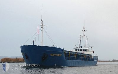
HAITHABU
General Cargo
Current Trip
| Trip Time | 8 h, 15 mins |
|---|---|
| Trip Distance | 60.84 nm |
| AVG Speed | 7.6 Knop |
| MAX Speed | 11.2 Knop |
| Djupgående | 3.2 m |
| AVG Wind | 10.3 knots |
| MAX Wind | 18.4 knots |
| MIN Temp | 3.6°C / 38.48°F |
| MAX Temp | 7.9°C / 46.22°F |
| Position mottagen | 3 m sen |
Current Position
| Longitud | 10.25950° |
|---|---|
| Latitude | 54.94250° |
| Status | Moored |
| Fart | |
| Kurs | 155° |
| Område | Kattegat |
| Station | T-AIS |
| Position mottagen | 3 m sen |
Info
Information
The current position of HAITHABU is in Kattegat with coordinates 54.94250° / 10.25950° as reported on 2024-04-24 14:47 by AIS to our vessel tracker app. The vessel's current speed is 0 Knop and is currently inside the port of SOEBY.
The vessel HAITHABU (IMO: 8222185, MMSI: 210061000) is a General Cargo that was built in 1984 ( 40 År gammal ). It's sailing under the flag of [CY] Cyprus.
In this page you can find informations about the vessels current position, last detected port calls, and current voyage information. If the vessels is not in coverage by AIS you will find the latest position.
The current position of HAITHABU is detected by our AIS receivers and we are not responsible for the reliability of the data. The last position was recorded while the vessel was in Coverage by the Ais receivers of our vessel tracking app.
The current draught of HAITHABU as reported by AIS is 3.2 meters
Weather
| Temperature | 6°C / 42.8°F |
|---|---|
| Wind Speed | 10 knots |
| Direction | 107° ESE |
| Pressure | 1005.6 hPa |
| Humidity | 75.6 % |
| Cloud Coverage | 100 % |
Featured Company
Last Port Calls
| Port | Arrival | Departure | Time In Port |
|---|---|---|---|
| 2024-04-23 14:32 | |||
| 2024-04-06 19:39 | 2024-04-23 06:17 | 16 d | |
| 2024-04-03 16:03 | 2024-04-05 16:06 | 2 d | |
| 2024-03-31 07:18 | 2024-04-02 17:15 | 2 d | |
| 2024-03-28 11:55 | 2024-03-29 10:54 | 22 h | |
| 2024-03-22 19:35 | 2024-03-23 17:38 | 22 h | |
| 2024-03-20 19:12 | 2024-03-22 09:36 | 1 d | |
| 2024-03-15 12:39 | 2024-03-18 14:19 | 3 d | |
| 2024-03-07 02:25 | 2024-03-11 14:03 | 4 d | |
| 2024-03-02 06:11 | 2024-03-05 21:39 | 3 d |
Last Trips
| Origin | Departure | Destination | Arrival | Distance | |
|---|---|---|---|---|---|
| 2024-04-23 08:17 | 2024-04-23 16:32 | 60.84 nm | |||
| 2024-04-05 18:06 | 2024-04-06 21:39 | 208.34 nm | |||
| 2024-04-02 19:15 | 2024-04-03 18:03 | 187.56 nm | |||
| 2024-03-29 11:54 | 2024-03-31 09:18 | 362.04 nm | |||
| 2024-03-23 18:38 | 2024-03-28 12:55 | 656.77 nm | |||
| 2024-03-22 10:36 | 2024-03-22 20:35 | 66.36 nm | |||
| 2024-03-18 15:19 | 2024-03-20 20:12 | 431.11 nm | |||
| 2024-03-11 15:03 | 2024-03-15 13:39 | 542.40 nm | |||
| 2024-03-05 22:39 | 2024-03-07 03:25 | 272.85 nm | |||
| 2024-03-01 15:06 | 2024-03-02 07:11 | 125.91 nm |
Events
| Tid | Event | Detaljer | Position / Dest | Information |
|---|---|---|---|---|
| 2024-04-23 14:56 | Status ändrad | Moored Under way using engine |
54.94255 / 10.25950
[DK] SOEBY
|
Fart: Kurs: 155° |
| 2024-04-23 14:35 | STOPPAR förflyttning |
54.94320 / 10.25820
[DK] SOEBY
|
Fart: 0.2 kn Kurs: 136° |
|
| 2024-04-23 14:32 | ANLÄNDER HAMN |
|
54.94404 / 10.25887
[DK] SOEBY
|
Fart: 2.2 kn Kurs: 203° |
| 2024-04-23 14:28 | STARTAR förflyttning | 0.25 nm, North East of SOEBY |
54.94630 / 10.26240
SOBY
|
Fart: 3.9 kn Kurs: 243° |
| 2024-04-23 14:18 | STOPPAR förflyttning | 0.36 nm, North East of SOEBY |
54.94751 / 10.26485
SOBY
|
Fart: 0.3 kn Kurs: 222° |
| 2024-04-23 12:40 | Byter havsområde | Danish part of the Kattegat Danish part of the Baltic Sea |
54.81007 / 10.22504
Kattegat
SOBY
|
Fart: 10.5 kn Kurs: 350.9° |
| 2024-04-23 12:16 | Byter havsområde | Danish part of the Baltic Sea German part of the Baltic Sea |
54.74154 / 10.24341
Baltic Sea
SOBY
|
Fart: 10.3 kn Kurs: 352.3° |
| 2024-04-23 09:43 | STARTAR förflyttning | 1.32 nm, South West of STICKENHΟRN SPORT |
54.36512 / 10.14576
SOBY
|
Fart: 5.2 kn Kurs: 105.7° |
| 2024-04-23 09:24 | ETA ändrat | 2024/04/23 17:00 2024/04/23 16:00 |
54.36560 / 10.14251
SOBY
|
Fart: Kurs: 103° |
| 2024-04-23 09:16 | STOPPAR förflyttning | 1.37 nm, South West of STICKENHΟRN SPORT |
54.36558 / 10.14251
SOBY
|
Fart: 0.2 kn Kurs: 104° |