
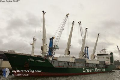
GREEN AUSTEVOLL
Reefer
Current Trip
ESLPA
| Time Travelled | 3 days |
|---|---|
| Remaining Time | --- |
| Distance Travelled | 72.67 nm |
| Remaining Distance | --- |
| AVG Speed | 13.2 Knop |
| MAX Speed | 18 Knop |
| AVG Wind | 6.4 knots |
| MAX Wind | 13 knots |
| MIN Temp | 23.4°C / 74.12°F |
| MAX Temp | 34.4°C / 93.92°F |
| Djupgående | 5.2 m |
| Position mottagen | 27 d sen |
Current Position
| Longitud | -15.40209° |
|---|---|
| Latitude | 27.63662° |
| Status | Under way using engine |
| Fart | 13 Knop |
| Kurs | 201.2° |
| Område | North Atlantic Ocean |
| Station | T-AIS |
| Position mottagen | 27 d sen |
Info
Information
The current position of GREEN AUSTEVOLL is in North Atlantic Ocean with coordinates 27.63662° / -15.40209° as reported on 2024-03-27 05:51 by AIS to our vessel tracker app. The vessel's current speed is 13 Knop
The vessel GREEN AUSTEVOLL (IMO: 8819299, MMSI: 311043800) is a Reefer that was built in 1991 ( 33 År gammal ). It's sailing under the flag of [BS] Bahamas.
In this page you can find informations about the vessels current position, last detected port calls, and current voyage information. If the vessels is not in coverage by AIS you will find the latest position.
The current position of GREEN AUSTEVOLL is detected by our AIS receivers and we are not responsible for the reliability of the data. The last position was recorded while the vessel was in Coverage by the Ais receivers of our vessel tracking app.
The current draught of GREEN AUSTEVOLL as reported by AIS is 5.2 meters
Weather
| Temperature | 26.7°C / 80.06°F |
|---|---|
| Wind Speed | 2 knots |
| Direction | 347° NNW |
| Pressure | 1011.6 hPa |
| Humidity | 86.5 % |
| Cloud Coverage | 100 % |
Featured Company
Last Port Calls
| Port | Arrival | Departure | Time In Port |
|---|---|---|---|
| 2024-04-15 11:13 | 2024-04-19 11:53 | 4 d | |
| 2024-04-07 01:19 | 2024-04-09 20:40 | 2 d | |
| 2024-03-26 01:50 | 2024-03-27 03:22 | 1 d | |
| 2024-03-19 21:25 | |||
| 2024-03-02 14:16 | 2024-03-02 23:23 | 9 h | |
| 2024-02-15 10:15 | 2024-02-17 22:10 | 2 d | |
| 2024-02-01 15:40 |
Last Trips
| Origin | Departure | Destination | Arrival | Distance | |
|---|---|---|---|---|---|
| 2024-04-09 20:40 | 2024-04-15 12:13 | 1295.67 nm | |||
| 2024-03-27 03:22 | 2024-04-07 01:19 | 2111.10 nm | |||
| 2024-03-19 22:25 | 2024-03-26 01:50 | 953.77 nm | |||
| 2024-02-17 19:10 | 2024-03-02 14:16 | 3937.74 nm | |||
| 2024-02-01 15:40 | 2024-02-15 07:15 | 3941.93 nm |
Events
| Tid | Event | Detaljer | Position / Dest | Information |
|---|---|---|---|---|
| 2024-04-20 14:31 | STOPPAR förflyttning | 5.63 nm, West of SOYO |
-6.10500 / 12.23667
ESLPA
|
Fart: Kurs: -1° |
| 2024-04-20 09:52 | STARTAR förflyttning | 0.8 nm, South West of BOMA |
-5.86500 / 13.03667
ESLPA
|
Fart: 5 kn Kurs: 290° |
| 2024-04-19 14:22 | STOPPAR förflyttning | 0.76 nm, South West of BOMA |
-5.86667 / 13.03833
ESLPA
|
Fart: Kurs: -1° |
| 2024-04-19 11:53 | AVGÅTT HAMN |
|
-5.89500 / 13.10667
ESLPA
|
Fart: Kurs: -1° |
| 2024-04-15 11:13 | STOPPAR förflyttning |
-5.85833 / 13.43167
[CD] SOCOPE
|
Fart: Kurs: -1° |
|
| 2024-04-15 11:13 | ANLÄNDER HAMN |
|
-5.85833 / 13.43167
[CD] SOCOPE
|
Fart: 7 kn Kurs: 106° |
| 2024-04-15 07:53 | STARTAR förflyttning | 0.4 nm, South East of BOMA |
-5.86526 / 13.05130
ESLPA
|
Fart: 4.6 kn Kurs: 89° |
| 2024-04-14 14:07 | STOPPAR förflyttning | 0.35 nm, South of BOMA |
-5.86500 / 13.04833
ESLPA
|
Fart: Kurs: -1° |
| 2024-04-14 08:36 | STARTAR förflyttning | 2.75 nm, South of BANANA |
-6.04412 / 12.41384
ESLPA
|
Fart: 4.4 kn Kurs: 138° |
| 2024-04-14 08:28 | STOPPAR förflyttning | 2.61 nm, South of BANANA |
-6.04167 / 12.41333
ESLPA
|
Fart: Kurs: -1° |