
GLOBAL PROSPERITY
Cargo
Current Trip
BR PMA
| Time Travelled | 8 days |
|---|---|
| Remaining Time | --- |
| Distance Travelled | 2309.33 nm |
| Remaining Distance | --- |
| AVG Speed | 12 Knop |
| MAX Speed | 13.5 Knop |
| AVG Wind | 12.5 knots |
| MAX Wind | 19 knots |
| MIN Temp | 24.1°C / 75.38°F |
| MAX Temp | 29.4°C / 84.92°F |
| Djupgående | 9.9 m |
| Position mottagen | 9 d sen |
Current Position
| Longitud | -44.37970° |
|---|---|
| Latitude | -2.56360° |
| Status | Moored |
| Fart | |
| Kurs | --- |
| Område | South Atlantic Ocean |
| Station | T-AIS |
| Position mottagen | 9 d sen |
Info
Information
The current position of GLOBAL PROSPERITY is in South Atlantic Ocean with coordinates -2.56360° / -44.37970° as reported on 2024-04-16 01:42 by AIS to our vessel tracker app. The vessel's current speed is 0 Knop
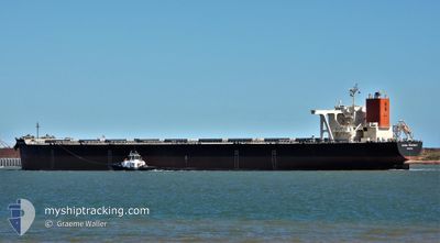
The vessel GLOBAL PROSPERITY (IMO: 9489508, MMSI: 636015714) is a Cargo It's sailing under the flag of [LR] Liberia.
In this page you can find informations about the vessels current position, last detected port calls, and current voyage information. If the vessels is not in coverage by AIS you will find the latest position.
The current position of GLOBAL PROSPERITY is detected by our AIS receivers and we are not responsible for the reliability of the data. The last position was recorded while the vessel was in Coverage by the Ais receivers of our vessel tracking app.
The current draught of GLOBAL PROSPERITY as reported by AIS is 9.9 meters
Weather
| Temperature | 24.1°C / 75.38°F |
|---|---|
| Wind Speed | 17 knots |
| Direction | 83° E |
| Pressure | 1019.5 hPa |
| Humidity | 61.3 % |
| Cloud Coverage | 71 % |
Featured Company
Most Visited Ports (Last year)
| Port | Arrivals | |
|---|---|---|
| 5 | ||
| 3 | ||
| 2 | ||
| 2 | ||
| 1 |
Events
| Tid | Event | Detaljer | Position / Dest | Information |
|---|---|---|---|---|
| 2024-04-17 03:52 | STARTAR förflyttning | 1.13 nm, North West of ITAQUI |
-2.55939 / -44.38343
BR PMA
|
Fart: 3.5 kn Kurs: 351° |
| 2024-04-17 03:52 | AVGÅTT HAMN |
|
-2.55939 / -44.38343
BR PMA
|
Fart: 0.5 kn Kurs: 342° |
| 2024-04-16 01:58 | Status ändrad | Default Moored |
-2.56364 / -44.37972
[BR] ITAQUI
|
Fart: Kurs: 0° |
| 2024-04-16 01:42 | UTANFÖR täckningsområde |
-2.56360 / -44.37970
South Atlantic Ocean
[BR] ITAQUI
|
Fart: Kurs: 213° |
|
| 2024-04-16 01:12 | Status ändrad | Moored Default |
-2.56361 / -44.37970
[BR] ITAQUI
|
Fart: Kurs: 204° |
| 2024-04-16 01:12 | I täckningsområde |
-2.56361 / -44.37970
South Atlantic Ocean
[BR] ITAQUI
|
Fart: Kurs: 204.4° |
|
| 2024-04-15 15:18 | Status ändrad | Default Moored |
-2.56365 / -44.37963
[BR] ITAQUI
|
Fart: 0.1 kn Kurs: 0° |
| 2024-04-15 15:03 | UTANFÖR täckningsområde |
-2.56364 / -44.37961
South Atlantic Ocean
[BR] ITAQUI
|
Fart: 0.1 kn Kurs: 196.1° |
|
| 2024-04-15 13:48 | Status ändrad | Moored Default |
-2.56368 / -44.37964
[BR] ITAQUI
|
Fart: Kurs: 265° |
| 2024-04-15 13:30 | I täckningsområde |
-2.56368 / -44.37964
South Atlantic Ocean
[BR] ITAQUI
|
Fart: Kurs: 264.7° |