
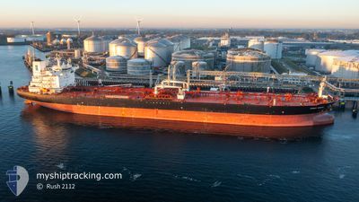
FRONT SIRIUS
Tanker
Current Trip
| Time Travelled | 13 days |
|---|---|
| Remaining Time | --- |
| Distance Travelled | 2432.62 nm |
| Remaining Distance | 277.23 nm |
| AVG Speed | 9.8 Knop |
| MAX Speed | 14 Knop |
| AVG Wind | 13.2 knots |
| MAX Wind | 30 knots |
| MIN Temp | 2.9°C / 37.22°F |
| MAX Temp | 21.9°C / 71.42°F |
| Djupgående | 8.8 m |
| Position mottagen | 10 d sen |
Current Position
| Longitud | --- |
|---|---|
| Latitude | --- |
| Status | Under way using engine |
| Fart | 10.1 Knop |
| Kurs | 171.3° |
| Område | Ionian Sea |
| Station | T-AIS |
| Position mottagen | 10 d sen |
Info
Information
The current position of FRONT SIRIUS is in Ionian Sea with coordinates 37.42807° / 19.57165° as reported on 2025-11-26 12:37 by AIS to our vessel tracker app. The vessel's current speed is 10.1 Knop and is heading at the port of MARSAXLOKK. The estimated time of arrival as calculated by MyShipTracking vessel tracking app is 2025-11-27 08:00 LT
The vessel FRONT SIRIUS (IMO: 9767340, MMSI: 538007337) is a Tanker It's sailing under the flag of [MH] Marshall Is.
In this page you can find informations about the vessels current position, last detected port calls, and current voyage information. If the vessels is not in coverage by AIS you will find the latest position.
The current position of FRONT SIRIUS is detected by our AIS receivers and we are not responsible for the reliability of the data. The last position was recorded while the vessel was in Coverage by the Ais receivers of our vessel tracking app.
The current draught of FRONT SIRIUS as reported by AIS is 8.8 meters
Weather
| Temperature | 17.1°C / 62.78°F |
|---|---|
| Wind Speed | 19 knots |
| Direction | 284° WNW |
| Pressure | 1018.6 hPa |
| Humidity | 86.2 % |
| Cloud Coverage | 11 % |
Featured Company
Last Port Calls
Most Visited Ports (Last year)
| Port | Arrivals | |
|---|---|---|
| 3 | ||
| 2 | ||
| 2 | ||
| 2 | ||
| 2 | ||
| 2 |
Last Trips
| Origin | Departure | Destination | Arrival | Distance | |
|---|---|---|---|---|---|
| 2025-10-30 09:27 | 2025-11-22 16:18 | 3767.08 nm | |||
| 2025-10-22 15:58 | 2025-10-29 07:24 | 1035.97 nm | |||
| 2025-10-12 13:06 | 2025-10-21 06:17 | 681.66 nm | |||
| 2025-10-05 13:52 | 2025-10-10 14:08 | 1052.79 nm | |||
| 2025-09-30 04:48 | 2025-10-03 22:46 | 953.78 nm |
Events
| Tid | Event | Detaljer | Position / Dest | Information |
|---|---|---|---|---|
| 2025-12-03 07:28 | STARTAR förflyttning | 9.6 nm, West of EL DEKHEILA |
31.09863 / 29.62808
MTMAR FOR ORDERS
|
Fart: 3.7 kn Kurs: 345° |
| 2025-12-02 11:21 | STOPPAR förflyttning | 9.99 nm, South West of EL DEKHEILA |
31.08040 / 29.62798
MTMAR FOR ORDERS
|
Fart: 0.3 kn Kurs: 38° |
| 2025-12-02 09:41 | STARTAR förflyttning | 9.85 nm, West of EL DEKHEILA |
31.12309 / 29.61665
MTMAR FOR ORDERS
|
Fart: 5.6 kn Kurs: 136° |
| 2025-12-02 09:18 | STOPPAR förflyttning | 10.39 nm, West of EL DEKHEILA |
31.13521 / 29.60480
MTMAR FOR ORDERS
|
Fart: 0.3 kn Kurs: 105° |
| 2025-12-02 08:41 | STARTAR förflyttning | 11.88 nm, West of EL DEKHEILA |
31.12769 / 29.57646
MTMAR FOR ORDERS
|
Fart: 3.8 kn Kurs: 70° |
| 2025-12-01 22:47 | STOPPAR förflyttning | 12.06 nm, West of EL DEKHEILA |
31.12188 / 29.57363
MTMAR FOR ORDERS
|
Fart: 0.2 kn Kurs: 334° |
| 2025-11-28 16:14 | STOPPAR förflyttning | 2.2 nm, East of KALI LIMENES |
34.92903 / 24.84708
MTMAR FOR ORDERS
|
Fart: 0.2 kn Kurs: 233° |