
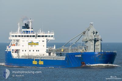
FITNES
Self Discharging Bulk Carrier
Current Trip
| Time Travelled | 4 days |
|---|---|
| Remaining Time | --- |
| Distance Travelled | 918.10 nm |
| Remaining Distance | 63.87 nm |
| AVG Speed | 11.3 Knop |
| MAX Speed | 17.4 Knop |
| AVG Wind | 13.1 knots |
| MAX Wind | 28 knots |
| MIN Temp | 2°C / 35.6°F |
| MAX Temp | 9.6°C / 49.28°F |
| Djupgående | 10.5 m |
| Position mottagen | 5 m sen |
Current Position
| Longitud | 1.69940° |
|---|---|
| Latitude | 51.91328° |
| Status | At anchor |
| Fart | 0.1 Knop |
| Kurs | 220° |
| Område | North Sea |
| Station | T-AIS |
| Position mottagen | 5 m sen |
Info
Information
The current position of FITNES is in North Sea with coordinates 51.91328° / 1.69940° as reported on 2024-04-25 15:36 by AIS to our vessel tracker app. The vessel's current speed is 0.1 Knop and is heading at the port of TILBURY. The estimated time of arrival as calculated by MyShipTracking vessel tracking app is 2024-04-25 04:00 LT
The vessel FITNES (IMO: 9490105, MMSI: 305530000) is a Self Discharging Bulk Carrier that was built in 2010 ( 14 År gammal ). It's sailing under the flag of [AG] Antigua Barbuda.
In this page you can find informations about the vessels current position, last detected port calls, and current voyage information. If the vessels is not in coverage by AIS you will find the latest position.
The current position of FITNES is detected by our AIS receivers and we are not responsible for the reliability of the data. The last position was recorded while the vessel was in Coverage by the Ais receivers of our vessel tracking app.
The current draught of FITNES as reported by AIS is 10.5 meters
Weather
| Temperature | 9.6°C / 49.28°F |
|---|---|
| Wind Speed | 15 knots |
| Direction | 267° W |
| Pressure | 1000.9 hPa |
| Humidity | 70.4 % |
| Cloud Coverage | 100 % |
Featured Company
Last Port Calls
| Port | Arrival | Departure | Time In Port |
|---|---|---|---|
| 2024-04-19 23:02 | 2024-04-20 22:40 | 23 h | |
| 2024-04-16 08:07 | 2024-04-16 11:18 | 3 h | |
| 2024-04-15 09:04 | 2024-04-15 19:46 | 10 h | |
| 2024-04-14 22:02 | 2024-04-15 08:42 | 10 h | |
| 2024-04-12 07:04 | 2024-04-12 12:20 | 5 h | |
| 2024-04-10 03:07 | 2024-04-10 22:15 | 19 h | |
| 2024-04-04 21:13 | 2024-04-05 22:33 | 1 d | |
| 2024-04-01 13:31 | 2024-04-02 04:50 | 15 h | |
| 2024-03-29 16:00 | 2024-03-30 10:52 | 18 h | |
| 2024-03-26 09:39 | 2024-03-26 23:33 | 13 h |
Last Trips
| Origin | Departure | Destination | Arrival | Distance | |
|---|---|---|---|---|---|
| 2024-04-16 13:18 | 2024-04-20 01:02 | 706.19 nm | |||
| 2024-04-15 21:46 | 2024-04-16 10:07 | 155.26 nm | |||
| 2024-04-15 10:42 | 2024-04-15 11:04 | 0.70 nm | |||
| 2024-04-12 14:20 | 2024-04-15 00:02 | 437.22 nm | |||
| 2024-04-11 00:15 | 2024-04-12 09:04 | 406.52 nm | |||
| 2024-04-06 00:33 | 2024-04-10 05:07 | 857.99 nm | |||
| 2024-04-02 06:50 | 2024-04-04 23:13 | 456.34 nm | |||
| 2024-03-30 11:52 | 2024-04-01 15:31 | 530.47 nm | |||
| 2024-03-27 00:33 | 2024-03-29 17:00 | 564.37 nm | |||
| 2024-03-24 13:17 | 2024-03-26 10:39 | 419.05 nm |
Events
| Tid | Event | Detaljer | Position / Dest | Information |
|---|---|---|---|---|
| 2024-04-25 10:45 | Status ändrad | At anchor Default |
51.90931 / 1.69640
GB TIL
|
Fart: Kurs: -1° |
| 2024-04-25 10:43 | Status ändrad | Default At anchor |
51.90833 / 1.69500
GB TIL
|
Fart: 0.2 kn Kurs: 12° |
| 2024-04-25 09:45 | Status ändrad | At anchor Default |
51.90917 / 1.69611
GB TIL
|
Fart: Kurs: -1° |
| 2024-04-25 09:43 | Status ändrad | Default At anchor |
51.90833 / 1.69500
GB TIL
|
Fart: 0.2 kn Kurs: 14° |
| 2024-04-25 08:42 | Status ändrad | At anchor Default |
51.90913 / 1.69630
GB TIL
|
Fart: 0.1 kn Kurs: 10° |
| 2024-04-25 08:39 | Status ändrad | Default At anchor |
51.90915 / 1.69635
GB TIL
|
Fart: 0.1 kn Kurs: 7° |
| 2024-04-25 07:15 | STOPPAR förflyttning | 15.11 nm, East of FELIXSTOWE |
51.90814 / 1.69807
GB TIL
|
Fart: 0.3 kn Kurs: 9° |
| 2024-04-25 07:09 | Status ändrad | At anchor Under way using engine |
51.90890 / 1.69901
GB TIL
|
Fart: 0.7 kn Kurs: 348° |
| 2024-04-25 03:51 | Status ändrad | Under way using engine Default |
52.30626 / 2.14492
GB TIL
|
Fart: 9.9 kn Kurs: 202° |
| 2024-04-25 03:45 | Status ändrad | Default Under way using engine |
52.32185 / 2.15571
GB TIL
|
Fart: 9.6 kn Kurs: 202° |