
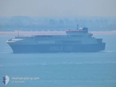
EUROCARGO SALERNO
Ro-Ro Cargo
Current Trip
| Time Travelled | 19 h, 1 mins |
|---|---|
| Remaining Time | 2 days |
| Distance Travelled | 241.53 nm |
| Remaining Distance | 930.40 nm |
| AVG Speed | 13.6 Knop |
| MAX Speed | 14.2 Knop |
| AVG Wind | 11.4 knots |
| MAX Wind | 19.3 knots |
| MIN Temp | 11°C / 51.8°F |
| MAX Temp | 14.4°C / 57.92°F |
| Djupgående | 6.6 m |
| Position mottagen | 1 h, 18 m sen |
Current Position
| Longitud | 16.51561° |
|---|---|
| Latitude | 41.94310° |
| Status | Under way using engine |
| Fart | 13.2 Knop |
| Kurs | 134.4° |
| Område | Adriatic Sea |
| Station | T-AIS |
| Position mottagen | 1 h, 18 m sen |
Info
Information
The current position of EUROCARGO SALERNO is in Adriatic Sea with coordinates 41.94310° / 16.51561° as reported on 2024-04-24 11:09 by AIS to our vessel tracker app. The vessel's current speed is 13.2 Knop and is heading at the port of ALEXANDRIA. The estimated time of arrival as calculated by MyShipTracking vessel tracking app is 2024-04-27 07:21 LT
The vessel EUROCARGO SALERNO (IMO: 9175494, MMSI: 229706000) is a Ro-Ro Cargo that was built in 1998 ( 26 År gammal ). It's sailing under the flag of [MT] Malta.
In this page you can find informations about the vessels current position, last detected port calls, and current voyage information. If the vessels is not in coverage by AIS you will find the latest position.
The current position of EUROCARGO SALERNO is detected by our AIS receivers and we are not responsible for the reliability of the data. The last position was recorded while the vessel was in Coverage by the Ais receivers of our vessel tracking app.
The current draught of EUROCARGO SALERNO as reported by AIS is 6.6 meters
Weather
| Temperature | 12.9°C / 55.22°F |
|---|---|
| Wind Speed | 17 knots |
| Direction | 194° SSW |
| Pressure | 1007.7 hPa |
| Humidity | 70.2 % |
| Cloud Coverage | 98 % |
Featured Company
Last Port Calls
| Port | Arrival | Departure | Time In Port |
|---|---|---|---|
| 2024-04-23 06:28 | 2024-04-23 17:26 | 10 h | |
| 2024-04-22 07:28 | 2024-04-22 18:40 | 11 h | |
| 2024-04-21 07:26 | 2024-04-21 17:49 | 10 h | |
| 2024-04-18 15:11 | 2024-04-19 04:06 | 12 h | |
| 2024-04-15 17:32 | 2024-04-15 23:27 | 5 h | |
| 2024-04-14 11:18 | 2024-04-14 19:24 | 8 h | |
| 2024-04-09 05:03 | 2024-04-09 18:31 | 13 h | |
| 2024-04-08 09:56 | 2024-04-08 20:02 | 10 h | |
| 2024-04-01 06:58 | 2024-04-01 20:38 | 13 h | |
| 2024-03-27 02:25 | 2024-03-27 21:35 | 19 h |
Most Visited Ports (Last year)
| Port | Arrivals | |
|---|---|---|
| 22 | ||
| 15 | ||
| 15 | ||
| 11 | ||
| 9 | ||
| 9 |
Last Trips
| Origin | Departure | Destination | Arrival | Distance | |
|---|---|---|---|---|---|
| 2024-04-22 20:40 | 2024-04-23 08:28 | 112.90 nm | |||
| 2024-04-21 19:49 | 2024-04-22 09:28 | 18.46 nm | |||
| 2024-04-19 06:06 | 2024-04-21 09:26 | 678.11 nm | |||
| 2024-04-16 01:27 | 2024-04-18 17:11 | 884.61 nm | |||
| 2024-04-14 22:24 | 2024-04-15 19:32 | 229.62 nm | |||
| 2024-04-09 20:31 | 2024-04-14 14:18 | 1648.58 nm | |||
| 2024-04-08 22:02 | 2024-04-09 07:03 | 16.30 nm | |||
| 2024-04-01 22:38 | 2024-04-08 11:56 | 1797.01 nm | |||
| 2024-03-27 22:35 | 2024-04-01 08:58 | 1178.68 nm | |||
| 2024-03-26 18:15 | 2024-03-27 03:25 | 109.21 nm |
Events
| Tid | Event | Detaljer | Position / Dest | Information |
|---|---|---|---|---|
| 2024-04-24 11:48 | Status ändrad | Default Under way using engine |
41.83751 / 16.65742
EG ALY
|
Fart: 13.2 kn Kurs: 134.4° |
| 2024-04-24 11:09 | UTANFÖR täckningsområde |
41.94310 / 16.51561
Adriatic Sea
EG ALY
|
Fart: 13.2 kn Kurs: 134.4° |
|
| 2024-04-24 10:23 | ETA ändrat | 2024/04/27 07:30 2024/04/27 08:00 |
42.06304 / 16.34608
EG ALY
|
Fart: 13.5 kn Kurs: 132.2° |
| 2024-04-24 09:32 | Byter havsområde | Italian part of the Adriatic Sea Croatian part of the Adriatic Sea |
42.19781 / 16.15966
Adriatic Sea
EG ALY
|
Fart: 13.6 kn Kurs: 134.2° |
| 2024-04-24 08:46 | Upptäckt i hav | Croatian part of the Adriatic Sea |
42.31776 / 15.99422
Adriatic Sea
EG ALY
|
Fart: 13.4 kn Kurs: 134° |
| 2024-04-24 07:47 | Byter havsområde | Italian part of the Adriatic Sea Croatian part of the Adriatic Sea |
42.48034 / 15.77745
Adriatic Sea
EG ALY
|
Fart: 14.1 kn Kurs: 135.8° |
| 2024-04-24 05:09 | Upptäckt i hav | Croatian part of the Adriatic Sea |
42.90290 / 15.19460
Adriatic Sea
EG ALY
|
Fart: 13.7 kn Kurs: 133° |
| 2024-04-24 05:08 | I täckningsområde |
42.90290 / 15.19460
Adriatic Sea
EG ALY
|
Fart: 13.7 kn Kurs: 133° |
|
| 2024-04-24 00:55 | UTANFÖR täckningsområde |
43.57573 / 14.23984
Adriatic Sea
EG ALY
|
Fart: 13.4 kn Kurs: 136.3° |
|
| 2024-04-24 00:09 | Status ändrad | Under way using engine Default |
43.69796 / 14.07857
EG ALY
|
Fart: 13.8 kn Kurs: 134° |