
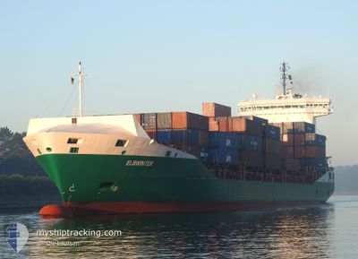
ELBWINTER
Container Ship
Current Trip
| Time Travelled | 2 days |
|---|---|
| Remaining Time | 2 h, 30 mins |
| Distance Travelled | 409.03 nm |
| Remaining Distance | 36.31 nm |
| AVG Speed | 10.1 Knop |
| MAX Speed | 14.7 Knop |
| AVG Wind | 13.6 knots |
| MAX Wind | 21 knots |
| MIN Temp | 15.9°C / 60.62°F |
| MAX Temp | 27.6°C / 81.68°F |
| Djupgående | 7.8 m |
| Position mottagen | 1 m sen |
Current Position
| Longitud | -4.62305° |
|---|---|
| Latitude | 36.30831° |
| Status | Under way using engine |
| Fart | 1.1 Knop |
| Kurs | 86° |
| Område | Alboran Sea |
| Station | T-AIS |
| Position mottagen | 1 m sen |
Info
Information
The current position of ELBWINTER is in Alboran Sea with coordinates 36.30831° / -4.62305° as reported on 2024-04-19 21:24 by AIS to our vessel tracker app. The vessel's current speed is 1.1 Knop and is heading at the port of ALGECIRAS. The estimated time of arrival as calculated by MyShipTracking vessel tracking app is 2024-04-19 23:55 LT
The vessel ELBWINTER (IMO: 9398773, MMSI: 212008000) is a Container Ship that was built in 2008 ( 16 År gammal ). It's sailing under the flag of [CY] Cyprus.
In this page you can find informations about the vessels current position, last detected port calls, and current voyage information. If the vessels is not in coverage by AIS you will find the latest position.
The current position of ELBWINTER is detected by our AIS receivers and we are not responsible for the reliability of the data. The last position was recorded while the vessel was in Coverage by the Ais receivers of our vessel tracking app.
The current draught of ELBWINTER as reported by AIS is 7.8 meters
Weather
| Temperature | 16.9°C / 62.42°F |
|---|---|
| Wind Speed | 15 knots |
| Direction | 98° E |
| Pressure | 1018.4 hPa |
| Humidity | 70.8 % |
| Cloud Coverage | 100 % |
Featured Company
Last Port Calls
| Port | Arrival | Departure | Time In Port |
|---|---|---|---|
| 2024-04-17 00:22 | 2024-04-17 13:42 | 13 h | |
| 2024-04-15 15:03 | 2024-04-16 08:15 | 17 h | |
| 2024-04-14 10:28 | 2024-04-15 00:24 | 13 h | |
| 2024-04-11 23:16 | 2024-04-12 17:18 | 18 h | |
| 2024-04-11 07:31 | 2024-04-11 10:45 | 3 h | |
| 2024-04-09 10:50 | 2024-04-11 04:28 | 1 d | |
| 2024-04-08 06:35 | 2024-04-08 19:24 | 12 h | |
| 2024-04-06 09:08 | 2024-04-06 19:09 | 10 h | |
| 2024-04-05 00:42 | 2024-04-05 14:44 | 14 h | |
| 2024-04-02 10:33 | 2024-04-03 03:26 | 16 h |
Most Visited Ports (Last year)
| Port | Arrivals | |
|---|---|---|
| 18 | ||
| 13 | ||
| 12 | ||
| 12 | ||
| 12 | ||
| 12 |
Last Trips
| Origin | Departure | Destination | Arrival | Distance | |
|---|---|---|---|---|---|
| 2024-04-16 09:15 | 2024-04-17 01:22 | 215.65 nm | |||
| 2024-04-15 02:24 | 2024-04-15 16:03 | 97.46 nm | |||
| 2024-04-12 19:18 | 2024-04-14 12:28 | 541.31 nm | |||
| 2024-04-11 12:45 | 2024-04-12 01:16 | 5.06 nm | |||
| 2024-04-11 04:28 | 2024-04-11 09:31 | 20.26 nm | |||
| 2024-04-08 21:24 | 2024-04-09 10:50 | 95.00 nm | |||
| 2024-04-06 20:09 | 2024-04-08 08:35 | 353.05 nm | |||
| 2024-04-05 15:44 | 2024-04-06 10:08 | 223.30 nm | |||
| 2024-04-03 05:26 | 2024-04-05 01:42 | 135.06 nm | |||
| 2024-03-31 18:58 | 2024-04-02 12:33 | 541.26 nm |
Events
| Tid | Event | Detaljer | Position / Dest | Information |
|---|---|---|---|---|
| 2024-04-18 22:26 | Byter havsområde | Spanish part of the Alboran Sea Spanish part of the Strait of Gibraltar |
35.99838 / -5.30259
Alboran Sea
ESALG
|
Fart: 9.9 kn Kurs: 82° |
| 2024-04-18 22:05 | Byter havsområde | Spanish part of the Strait of Gibraltar Moroccan part of the Strait of Gibraltar |
35.98331 / -5.37001
Strait of Gibraltar
ESALG
|
Fart: 9.6 kn Kurs: 72.1° |
| 2024-04-18 19:26 | Status ändrad | Under way using engine Default |
35.91910 / -5.82406
ESALG
|
Fart: 10.1 kn Kurs: 89° |
| 2024-04-18 19:15 | Status ändrad | Default Under way using engine |
35.91807 / -5.85942
ESALG
|
Fart: 10.1 kn Kurs: 88.9° |
| 2024-04-18 19:07 | Byter havsområde | Moroccan part of the Strait of Gibraltar Moroccan part of the North Atlantic Ocean |
35.91770 / -5.88710
Strait of Gibraltar
ESALG
|
Fart: 10.1 kn Kurs: 88.9° |
| 2024-04-18 19:06 | Status ändrad | Under way using engine Default |
35.91764 / -5.89062
ESALG
|
Fart: 10 kn Kurs: 86° |
| 2024-04-18 18:56 | I täckningsområde |
35.91770 / -5.88710
Strait of Gibraltar
ESALG
|
Fart: 10.1 kn Kurs: 88.9° |
|
| 2024-04-18 17:35 | Status ändrad | Default Under way using engine |
35.90309 / -6.21145
ESALG
|
Fart: 10.7 kn Kurs: 96.2° |
| 2024-04-18 17:24 | UTANFÖR täckningsområde |
35.90494 / -6.25105
North Atlantic Ocean
ESALG
|
Fart: 10.7 kn Kurs: 96.2° |
|
| 2024-04-18 16:56 | Byter havsområde | Moroccan part of the North Atlantic Ocean Spanish part of the North Atlantic Ocean |
35.91903 / -6.35088
North Atlantic Ocean
ESALG
|
Fart: 10.7 kn Kurs: 103.2° |