
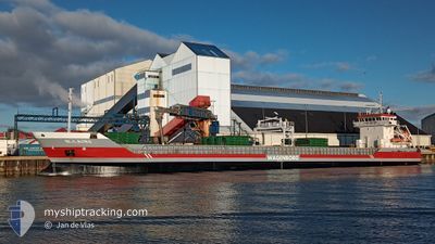
NIJLBORG
General Cargo
Current Trip
| Trip Time | 3 days |
|---|---|
| Trip Distance | 857.79 nm |
| AVG Speed | 9.8 Knop |
| MAX Speed | 11.5 Knop |
| Djupgående | 6.4 m |
| AVG Wind | 15.3 knots |
| MAX Wind | 22.9 knots |
| MIN Temp | -3.9°C / 24.98°F |
| MAX Temp | 6.3°C / 43.34°F |
| Position mottagen | 2 d sen |
Current Position
| Longitud | 20.78265° |
|---|---|
| Latitude | 63.54370° |
| Status | Under way using engine |
| Fart | 10.1 Knop |
| Kurs | 71.1° |
| Område | Gulf of Bothnia |
| Station | T-AIS |
| Position mottagen | 2 d sen |
Info
Information
The current position of NIJLBORG is in Gulf of Bothnia with coordinates 63.54370° / 20.78265° as reported on 2024-04-22 01:49 by AIS to our vessel tracker app. The vessel's current speed is 10.1 Knop and is currently inside the port of ROYTTA.
The vessel NIJLBORG (IMO: 9313802, MMSI: 246371000) is a General Cargo that was built in 2005 ( 19 År gammal ). It's sailing under the flag of [NL] Netherlands.
In this page you can find informations about the vessels current position, last detected port calls, and current voyage information. If the vessels is not in coverage by AIS you will find the latest position.
The current position of NIJLBORG is detected by our AIS receivers and we are not responsible for the reliability of the data. The last position was recorded while the vessel was in Coverage by the Ais receivers of our vessel tracking app.
The current draught of NIJLBORG as reported by AIS is 6.4 meters
Weather
| Temperature | -1°C / 30.2°F |
|---|---|
| Wind Speed | 4 knots |
| Direction | 122° ESE |
| Pressure | 1012.5 hPa |
| Humidity | 90.7 % |
| Cloud Coverage | 93 % |
Featured Company
Last Port Calls
| Port | Arrival | Departure | Time In Port |
|---|---|---|---|
| 2024-04-22 21:56 | |||
| 2024-04-16 14:42 | 2024-04-19 05:56 | 2 d | |
| 2024-04-14 10:30 | 2024-04-15 20:33 | 1 d | |
| 2024-04-11 09:19 | 2024-04-13 14:44 | 2 d | |
| 2024-03-21 19:45 | 2024-03-23 15:44 | 1 d | |
| 2024-03-15 12:34 | 2024-03-20 04:11 | 4 d | |
| 2024-03-10 07:47 | 2024-03-15 00:14 | 4 d | |
| 2024-03-02 16:46 | 2024-03-05 09:53 | 2 d | |
| 2024-02-25 23:29 | 2024-02-25 23:31 | 2 m | |
| 2024-02-21 13:50 | 2024-02-24 09:55 | 2 d |
Most Visited Ports (Last year)
| Port | Arrivals | |
|---|---|---|
| 7 | ||
| 4 | ||
| 3 | ||
| 3 | ||
| 3 | ||
| 2 |
Last Trips
| Origin | Departure | Destination | Arrival | Distance | |
|---|---|---|---|---|---|
| 2024-04-19 07:56 | 2024-04-23 00:56 | 857.79 nm | |||
| 2024-04-15 22:33 | 2024-04-16 16:42 | 200.36 nm | |||
| 2024-04-13 16:44 | 2024-04-14 12:30 | 227.44 nm | |||
| 2024-03-23 16:44 | 2024-04-11 11:19 | 1769.42 nm | |||
| 2024-03-20 05:11 | 2024-03-21 20:45 | 106.85 nm | |||
| 2024-03-15 01:14 | 2024-03-15 13:34 | 124.82 nm | |||
| 2024-03-05 11:53 | 2024-03-10 08:47 | 1193.99 nm | |||
| 2024-02-26 00:31 | 2024-03-02 18:46 | 699.44 nm | |||
| 2024-02-24 10:55 | 2024-02-26 00:29 | 359.32 nm | |||
| 2024-02-21 14:08 | 2024-02-21 14:50 | 8.94 nm |
Events
| Tid | Event | Detaljer | Position / Dest | Information |
|---|---|---|---|---|
| 2024-04-22 22:00 | STOPPAR förflyttning |
65.75253 / 24.15763
[FI] ROYTTA
|
Fart: Kurs: 59° |
|
| 2024-04-22 21:56 | ANLÄNDER HAMN |
|
65.75201 / 24.15713
[FI] ROYTTA
|
Fart: 2.7 kn Kurs: 9° |
| 2024-04-22 19:56 | STARTAR förflyttning | 6.53 nm, South of AJOS |
65.55553 / 24.44467
FITOR
|
Fart: 7.4 kn Kurs: 21° |
| 2024-04-22 19:44 | STOPPAR förflyttning | 6.86 nm, South of AJOS |
65.55051 / 24.43949
FITOR
|
Fart: Kurs: 31° |
| 2024-04-22 19:20 | STARTAR förflyttning | 10.23 nm, South West of AJOS |
65.50425 / 24.34927
FITOR
|
Fart: 8.7 kn Kurs: 40° |
| 2024-04-22 19:08 | STOPPAR förflyttning | 10.6 nm, South West of AJOS |
65.49939 / 24.33980
FITOR
|
Fart: Kurs: 38° |
| 2024-04-22 17:24 | STARTAR förflyttning |
65.33415 / 23.95857
FITOR
|
Fart: 6.6 kn Kurs: 45° |
|
| 2024-04-22 16:28 | STOPPAR förflyttning |
65.33148 / 23.95762
FITOR
|
Fart: 0.3 kn Kurs: 80° |
|
| 2024-04-22 01:56 | Status ändrad | Default Under way using engine |
63.54921 / 20.82569
FITOR
|
Fart: 10.1 kn Kurs: 71.1° |
| 2024-04-22 01:49 | UTANFÖR täckningsområde |
63.54370 / 20.78265
Gulf of Bothnia
FITOR
|
Fart: 10.1 kn Kurs: 71.1° |