
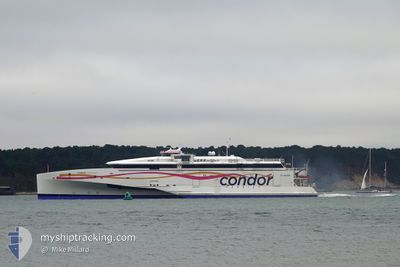
CONDOR LIBERATION
High speed craft
Current Trip
| Time Travelled | 22 mins |
|---|---|
| Remaining Time | 25 mins |
| Distance Travelled | 7.64 nm |
| Remaining Distance | 21.24 nm |
| AVG Speed | 32 Knop |
| MAX Speed | 32.5 Knop |
| AVG Wind | 18.6 knots |
| MAX Wind | 20.1 knots |
| MIN Temp | 10°C / 50°F |
| MAX Temp | 10.2°C / 50.36°F |
| Djupgående | 4.5 m |
| Position mottagen | 1 m sen |
Current Position
| Longitud | -2.43148° |
|---|---|
| Latitude | 49.29943° |
| Status | Under way using engine |
| Fart | 32.2 Knop |
| Kurs | 163.7° |
| Område | English Channel |
| Station | T-AIS |
| Position mottagen | 1 m sen |
Info
Information
The current position of CONDOR LIBERATION is in English Channel with coordinates 49.29943° / -2.43148° as reported on 2024-04-16 12:18 by AIS to our vessel tracker app. The vessel's current speed is 32.2 Knop and is heading at the port of JERSEY. The estimated time of arrival as calculated by MyShipTracking vessel tracking app is 2024-04-16 12:44 LT
The vessel CONDOR LIBERATION (IMO: 9551363, MMSI: 311037300) is a High speed craft that was built in 2010 ( 14 År gammal ). It's sailing under the flag of [BS] Bahamas.
In this page you can find informations about the vessels current position, last detected port calls, and current voyage information. If the vessels is not in coverage by AIS you will find the latest position.
The current position of CONDOR LIBERATION is detected by our AIS receivers and we are not responsible for the reliability of the data. The last position was recorded while the vessel was in Coverage by the Ais receivers of our vessel tracking app.
The current draught of CONDOR LIBERATION as reported by AIS is 4.5 meters
Weather
| Temperature | 10°C / 50°F |
|---|---|
| Wind Speed | 20 knots |
| Direction | 312° NW |
| Pressure | 1017.8 hPa |
| Humidity | 79.5 % |
| Cloud Coverage | 85 % |
Featured Company
Last Port Calls
| Port | Arrival | Departure | Time In Port |
|---|---|---|---|
| 2024-04-16 11:15 | 2024-04-16 11:57 | 42 m | |
| 2024-04-14 19:24 | 2024-04-16 08:12 | 1 d | |
| 2024-04-14 15:10 | 2024-04-14 16:11 | 1 h | |
| 2024-04-14 12:52 | 2024-04-14 14:10 | 1 h | |
| 2024-04-14 11:05 | 2024-04-14 11:48 | 42 m | |
| 2024-04-13 16:40 | 2024-04-14 08:02 | 15 h | |
| 2024-04-13 13:02 | 2024-04-13 13:44 | 42 m | |
| 2024-04-13 11:20 | 2024-04-13 12:08 | 48 m | |
| 2024-04-13 09:33 | 2024-04-13 10:20 | 46 m | |
| 2024-04-12 16:38 | 2024-04-13 06:35 | 13 h |
Last Trips
| Origin | Departure | Destination | Arrival | Distance | |
|---|---|---|---|---|---|
| 2024-04-16 09:12 | 2024-04-16 12:15 | 82.38 nm | |||
| 2024-04-14 17:11 | 2024-04-14 20:24 | 81.44 nm | |||
| 2024-04-14 15:10 | 2024-04-14 16:10 | 27.25 nm | |||
| 2024-04-14 12:48 | 2024-04-14 13:52 | 27.43 nm | |||
| 2024-04-14 09:02 | 2024-04-14 12:05 | 82.63 nm | |||
| 2024-04-13 14:44 | 2024-04-13 17:40 | 81.32 nm | |||
| 2024-04-13 13:08 | 2024-04-13 14:02 | 26.84 nm | |||
| 2024-04-13 11:20 | 2024-04-13 12:20 | 27.77 nm | |||
| 2024-04-13 07:35 | 2024-04-13 10:33 | 82.35 nm | |||
| 2024-04-12 14:29 | 2024-04-12 17:38 | 81.62 nm |
Events
| Tid | Event | Detaljer | Position / Dest | Information |
|---|---|---|---|---|
| 2024-04-16 11:57 | AVGÅTT HAMN |
|
49.45621 / -2.52298
JERSEY
|
Fart: 7.9 kn Kurs: 80° |
| 2024-04-16 11:57 | STARTAR förflyttning |
49.45583 / -2.52554
[GG] GUERNSEY
|
Fart: 7 kn Kurs: 71° |
|
| 2024-04-16 11:27 | Destination ändrad | JERSEY ST PETER PORT |
49.45696 / -2.52994
[GG] GUERNSEY
|
Fart: Kurs: 159° |
| 2024-04-16 11:27 | ETA ändrat | 2024/04/16 13:00 2024/04/16 11:15 |
49.45696 / -2.52994
[GG] GUERNSEY
|
Fart: Kurs: 159° |
| 2024-04-16 11:18 | STOPPAR förflyttning |
49.45522 / -2.52834
[GG] GUERNSEY
|
Fart: 0.3 kn Kurs: 182° |
|
| 2024-04-16 11:15 | ANLÄNDER HAMN |
|
49.45553 / -2.52547
[GG] GUERNSEY
|
Fart: 5.8 kn Kurs: 265° |
| 2024-04-16 10:22 | Byter havsområde | Guernsey part of the English Channel United Kingdom part of the English Channel |
49.81414 / -2.25914
English Channel
ST PETER PORT
|
Fart: 29.4 kn Kurs: 200.4° |
| 2024-04-16 10:22 | Status ändrad | Under way using engine Default |
49.81414 / -2.25914
ST PETER PORT
|
Fart: 30.9 kn Kurs: 212° |
| 2024-04-16 10:17 | I täckningsområde |
49.81414 / -2.25914
English Channel
ST PETER PORT
|
Fart: 29.4 kn Kurs: 200.4° |
|
| 2024-04-16 09:05 | UTANFÖR täckningsområde |
50.43727 / -1.96341
English Channel
ST PETER PORT
|
Fart: 30.6 kn Kurs: 196.8° |