
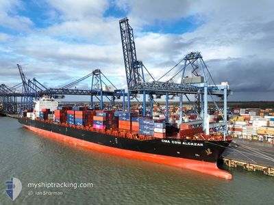
CMA CGM ALCAZAR
Container Ship
Current Trip
| Time Travelled | 7 days |
|---|---|
| Remaining Time | --- |
| Distance Travelled | 2303.46 nm |
| Remaining Distance | --- |
| AVG Speed | 14.5 Knop |
| MAX Speed | 20.4 Knop |
| AVG Wind | 11.7 knots |
| MAX Wind | 32.3 knots |
| MIN Temp | 7.3°C / 45.14°F |
| MAX Temp | 17.4°C / 63.32°F |
| Djupgående | 13 m |
| Position mottagen | 19 h, 22 m sen |
Current Position
| Longitud | 14.88487° |
|---|---|
| Latitude | 35.73627° |
| Status | Under way using engine |
| Fart | 0.9 Knop |
| Kurs | 346° |
| Område | Mediterranean Sea - Eastern Basin |
| Station | T-AIS |
| Position mottagen | 19 h, 22 m sen |
Info
Information
The current position of CMA CGM ALCAZAR is in Mediterranean Sea - Eastern Basin with coordinates 35.73627° / 14.88487° as reported on 2024-04-24 21:32 by AIS to our vessel tracker app. The vessel's current speed is 0.9 Knop
The vessel CMA CGM ALCAZAR (IMO: 9335197, MMSI: 357214000) is a Container Ship that was built in 2007 ( 17 År gammal ). It's sailing under the flag of [PA] Panama.
In this page you can find informations about the vessels current position, last detected port calls, and current voyage information. If the vessels is not in coverage by AIS you will find the latest position.
The current position of CMA CGM ALCAZAR is detected by our AIS receivers and we are not responsible for the reliability of the data. The last position was recorded while the vessel was in Coverage by the Ais receivers of our vessel tracking app.
The current draught of CMA CGM ALCAZAR as reported by AIS is 13 meters
Weather
| Temperature | 15.6°C / 60.08°F |
|---|---|
| Wind Speed | 19 knots |
| Direction | 280° W |
| Pressure | 1013.6 hPa |
| Humidity | 72.4 % |
| Cloud Coverage | 27 % |
Featured Company
Last Port Calls
| Port | Arrival | Departure | Time In Port |
|---|---|---|---|
| 2024-04-16 17:37 | 2024-04-18 03:11 | 1 d | |
| 2024-04-12 06:15 | 2024-04-14 01:32 | 1 d | |
| 2024-04-09 10:50 | 2024-04-10 22:30 | 1 d | |
| 2024-04-07 01:51 | 2024-04-08 08:50 | 1 d | |
| 2024-04-02 20:49 | 2024-04-03 08:27 | 11 h | |
| 2024-03-24 16:09 | 2024-03-25 00:53 | 8 h | |
| 2024-03-21 00:08 | 2024-03-22 00:06 | 23 h | |
| 2024-03-16 20:13 | 2024-03-17 09:19 | 13 h | |
| 2024-03-15 10:52 | 2024-03-16 08:14 | 21 h | |
| 2024-03-13 08:54 | 2024-03-14 13:45 | 1 d |
Most Visited Ports (Last year)
| Port | Arrivals | |
|---|---|---|
| 10 | ||
| 8 | ||
| 8 | ||
| 8 | ||
| 8 | ||
| 8 |
Last Trips
| Origin | Departure | Destination | Arrival | Distance | |
|---|---|---|---|---|---|
| 2024-04-14 03:32 | 2024-04-16 19:37 | 271.52 nm | |||
| 2024-04-11 00:30 | 2024-04-12 08:15 | 407.38 nm | |||
| 2024-04-08 09:50 | 2024-04-09 12:50 | 381.91 nm | |||
| 2024-04-03 08:27 | 2024-04-07 02:51 | 1373.96 nm | |||
| 2024-03-25 01:53 | 2024-04-02 20:49 | 1239.45 nm | |||
| 2024-03-22 02:06 | 2024-03-24 17:09 | 801.14 nm | |||
| 2024-03-17 11:19 | 2024-03-21 02:08 | 355.34 nm | |||
| 2024-03-16 11:14 | 2024-03-16 22:13 | 176.67 nm | |||
| 2024-03-14 16:45 | 2024-03-15 13:52 | 90.63 nm | |||
| 2024-03-12 00:49 | 2024-03-13 11:54 | 368.98 nm |
Events
| Tid | Event | Detaljer | Position / Dest | Information |
|---|---|---|---|---|
| 2024-04-25 16:28 | STARTAR förflyttning |
35.65773 / 15.05557
MTMAR
|
Fart: 7.3 kn Kurs: 298° |
|
| 2024-04-25 08:17 | STOPPAR förflyttning | 17.86 nm, East of MARSAXLOKK |
35.77110 / 14.90698
MTMAR
|
Fart: 0.3 kn Kurs: 302° |
| 2024-04-25 07:00 | STARTAR förflyttning |
35.69113 / 15.01630
MTMAR
|
Fart: 3.2 kn Kurs: 240° |
|
| 2024-04-25 03:02 | STOPPAR förflyttning | 18.07 nm, East of MARSAXLOKK |
35.72405 / 14.89617
MTMAR
|
Fart: 0.2 kn Kurs: 288° |
| 2024-04-24 21:43 | Status ändrad | Default Under way using engine |
35.73373 / 14.88793
MTMAR
|
Fart: 0.9 kn Kurs: 346° |
| 2024-04-24 21:32 | UTANFÖR täckningsområde |
35.73627 / 14.88487
Mediterranean Sea - Eastern Basin
MTMAR
|
Fart: 0.9 kn Kurs: 128° |
|
| 2024-04-24 21:11 | Status ändrad | Under way using engine Default |
35.73703 / 14.87983
MTMAR
|
Fart: 4.9 kn Kurs: 44° |
| 2024-04-24 21:11 | I täckningsområde |
35.73703 / 14.87983
Mediterranean Sea - Eastern Basin
MTMAR
|
Fart: 1 kn Kurs: 50° |
|
| 2024-04-24 18:54 | Status ändrad | Default Under way using engine |
35.71095 / 14.49192
MTMAR
|
Fart: 11.3 kn Kurs: 105° |
| 2024-04-24 18:39 | UTANFÖR täckningsområde |
35.71180 / 14.43557
Mediterranean Sea - Eastern Basin
MTMAR
|
Fart: 11.3 kn Kurs: 105° |