
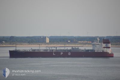
CLIPPER JUPITER
Tanker
Current Trip
| Time Travelled | 14 days |
|---|---|
| Remaining Time | --- |
| Distance Travelled | 5061.53 nm |
| Remaining Distance | --- |
| AVG Speed | 13.8 Knop |
| MAX Speed | 18.4 Knop |
| AVG Wind | 11.6 knots |
| MAX Wind | 22 knots |
| MIN Temp | 10.2°C / 50.36°F |
| MAX Temp | 25.3°C / 77.54°F |
| Djupgående | 11 m |
| Position mottagen | 1 m sen |
Current Position
| Longitud | -0.26676° |
|---|---|
| Latitude | 50.23348° |
| Status | Under way using engine |
| Fart | 14.3 Knop |
| Kurs | 72.2° |
| Område | English Channel |
| Station | T-AIS |
| Position mottagen | 1 m sen |
Info
Information
The current position of CLIPPER JUPITER is in English Channel with coordinates 50.23348° / -0.26676° as reported on 2024-04-19 09:52 by AIS to our vessel tracker app. The vessel's current speed is 14.3 Knop and is heading at the port of KARLSHAMN. The estimated time of arrival as calculated by MyShipTracking vessel tracking app is 2024-04-22 12:00 LT
The vessel CLIPPER JUPITER (IMO: 9699505, MMSI: 257694000) is a Tanker It's sailing under the flag of [NO] Norway.
In this page you can find informations about the vessels current position, last detected port calls, and current voyage information. If the vessels is not in coverage by AIS you will find the latest position.
The current position of CLIPPER JUPITER is detected by our AIS receivers and we are not responsible for the reliability of the data. The last position was recorded while the vessel was in Coverage by the Ais receivers of our vessel tracking app.
The current draught of CLIPPER JUPITER as reported by AIS is 11 meters
Weather
| Temperature | 10.6°C / 51.08°F |
|---|---|
| Wind Speed | 20 knots |
| Direction | 289° WNW |
| Pressure | 1018 hPa |
| Humidity | 86.7 % |
| Cloud Coverage | 56 % |
Featured Company
Last Port Calls
| Port | Arrival | Departure | Time In Port |
|---|---|---|---|
| 2024-04-02 15:55 | 2024-04-04 17:34 | 2 d | |
| 2024-03-13 01:28 | 2024-03-16 10:01 | 3 d | |
| 2024-03-09 15:50 | 2024-03-10 21:10 | 1 d | |
| 2024-03-06 11:44 | 2024-03-08 07:38 | 1 d | |
| 2024-03-02 16:39 | 2024-03-03 16:54 | 1 d | |
| 2024-03-01 08:32 | 2024-03-02 14:16 | 1 d | |
| 2024-02-21 16:01 | 2024-02-28 07:20 | 6 d | |
| 2024-02-16 12:34 | 2024-02-17 10:49 | 22 h | |
| 2024-02-13 16:51 | 2024-02-14 12:12 | 19 h | |
| 2024-02-08 23:53 | 2024-02-11 02:01 | 2 d |
Last Trips
| Origin | Departure | Destination | Arrival | Distance | |
|---|---|---|---|---|---|
| 2024-03-16 11:01 | 2024-04-02 10:55 | 5628.56 nm | |||
| 2024-03-10 22:10 | 2024-03-13 02:28 | 570.18 nm | |||
| 2024-03-08 08:38 | 2024-03-09 16:50 | 313.48 nm | |||
| 2024-03-03 17:54 | 2024-03-06 12:44 | 428.60 nm | |||
| 2024-03-02 15:16 | 2024-03-02 17:39 | 22.46 nm | |||
| 2024-02-28 07:20 | 2024-03-01 09:32 | 535.54 nm | |||
| 2024-02-17 10:49 | 2024-02-21 16:01 | 257.07 nm | |||
| 2024-02-14 13:12 | 2024-02-16 12:34 | 543.88 nm | |||
| 2024-02-11 03:01 | 2024-02-13 17:51 | 654.02 nm | |||
| 2024-01-21 18:47 | 2024-02-09 00:53 | 5469.61 nm |
Events
| Tid | Event | Detaljer | Position / Dest | Information |
|---|---|---|---|---|
| 2024-04-19 09:07 | Byter havsområde | United Kingdom part of the English Channel Guernsey part of the English Channel |
50.17407 / -.52929
English Channel
US HOU>SE KAN
|
Fart: 14.5 kn Kurs: 71.6° |
| 2024-04-19 09:06 | I täckningsområde |
50.17407 / -.52929
English Channel
US HOU>SE KAN
|
Fart: 14.5 kn Kurs: 71.6° |
|
| 2024-04-19 04:53 | UTANFÖR täckningsområde |
49.88619 / -2.26308
English Channel
US HOU>SE KAN
|
Fart: 16.7 kn Kurs: 75° |
|
| 2024-04-19 04:46 | Byter havsområde | Guernsey part of the English Channel United Kingdom part of the English Channel |
49.87768 / -2.31246
English Channel
US HOU>SE KAN
|
Fart: 16.7 kn Kurs: 72.7° |
| 2024-04-19 04:45 | Status ändrad | Under way using engine Default |
49.87548 / -2.32346
US HOU>SE KAN
|
Fart: 16.5 kn Kurs: 79° |
| 2024-04-19 04:45 | I täckningsområde |
49.87768 / -2.31246
English Channel
US HOU>SE KAN
|
Fart: 16.7 kn Kurs: 72.7° |
|
| 2024-04-18 23:18 | UTANFÖR täckningsområde |
49.48847 / -4.43907
English Channel
US HOU>SE KAN
|
Fart: 15 kn Kurs: 68.4° |
|
| 2024-04-18 23:18 | Status ändrad | Under way using engine Default |
49.48847 / -4.43907
US HOU>SE KAN
|
Fart: 15 kn Kurs: 74° |
| 2024-04-18 23:00 | Status ändrad | Default Under way using engine |
49.46499 / -4.54957
US HOU>SE KAN
|
Fart: 14.9 kn Kurs: 77.7° |
| 2024-04-18 21:40 | Byter havsområde | United Kingdom part of the English Channel Bahamas part of the North Atlantic Ocean |
49.40925 / -5.05511
English Channel
US HOU>SE KAN
|
Fart: 14.9 kn Kurs: 81.3° |