
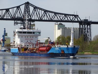
CIMIL
Oil/Chemical Tanker
Current Trip
| Time Travelled | 1 day |
|---|---|
| Remaining Time | 5 days |
| Distance Travelled | 227.61 nm |
| Remaining Distance | 1167.06 nm |
| AVG Speed | 9.1 Knop |
| MAX Speed | 11.7 Knop |
| AVG Wind | 12.8 knots |
| MAX Wind | 23.8 knots |
| MIN Temp | 4.1°C / 39.38°F |
| MAX Temp | 8.4°C / 47.12°F |
| Djupgående | 6.2 m |
| Position mottagen | Nu |
Current Position
| Longitud | -0.02065° |
|---|---|
| Latitude | 50.51017° |
| Status | Under way using engine |
| Fart | 8.1 Knop |
| Kurs | 253° |
| Område | English Channel |
| Station | T-AIS |
| Position mottagen | Nu |
Info
Information
The current position of CIMIL is in English Channel with coordinates 50.51017° / -0.02065° as reported on 2024-04-24 07:42 by AIS to our vessel tracker app. The vessel's current speed is 8.1 Knop and is heading at the port of HUELVA. The estimated time of arrival as calculated by MyShipTracking vessel tracking app is 2024-04-29 23:20 LT
The vessel CIMIL (IMO: 9487378, MMSI: 215909000) is a Oil/Chemical Tanker that was built in 2010 ( 14 År gammal ). It's sailing under the flag of [MT] Malta.
In this page you can find informations about the vessels current position, last detected port calls, and current voyage information. If the vessels is not in coverage by AIS you will find the latest position.
The current position of CIMIL is detected by our AIS receivers and we are not responsible for the reliability of the data. The last position was recorded while the vessel was in Coverage by the Ais receivers of our vessel tracking app.
The current draught of CIMIL as reported by AIS is 6.2 meters
Weather
| Temperature | 7°C / 44.6°F |
|---|---|
| Wind Speed | 16 knots |
| Direction | 353° N |
| Pressure | 1018.1 hPa |
| Humidity | 73.8 % |
| Cloud Coverage | 100 % |
Featured Company
Last Port Calls
| Port | Arrival | Departure | Time In Port |
|---|---|---|---|
| 2024-04-22 04:39 | 2024-04-23 06:53 | 1 d | |
| 2024-04-19 11:23 | 2024-04-20 06:04 | 18 h | |
| 2024-04-18 15:30 | 2024-04-19 10:33 | 19 h | |
| 2024-04-17 06:12 | 2024-04-18 13:37 | 1 d | |
| 2024-04-09 16:51 | 2024-04-13 12:11 | 3 d | |
| 2024-04-06 11:53 | 2024-04-06 16:59 | 5 h | |
| 2024-04-05 06:08 | 2024-04-06 10:40 | 1 d | |
| 2024-04-02 07:06 | 2024-04-03 04:55 | 21 h | |
| 2024-03-31 19:45 | 2024-04-01 18:25 | 22 h | |
| 2024-03-26 17:42 | 2024-03-27 08:58 | 15 h |
Most Visited Ports (Last year)
| Port | Arrivals | |
|---|---|---|
| 8 | ||
| 7 | ||
| 5 | ||
| 4 | ||
| 4 | ||
| 4 |
Last Trips
| Origin | Departure | Destination | Arrival | Distance | |
|---|---|---|---|---|---|
| 2024-04-20 08:04 | 2024-04-22 06:39 | 79.15 nm | |||
| 2024-04-19 12:33 | 2024-04-19 13:23 | 4.16 nm | |||
| 2024-04-18 15:37 | 2024-04-18 17:30 | 14.22 nm | |||
| 2024-04-13 14:11 | 2024-04-17 08:12 | 703.00 nm | |||
| 2024-04-06 18:59 | 2024-04-09 18:51 | 681.11 nm | |||
| 2024-04-06 12:40 | 2024-04-06 13:53 | 10.13 nm | |||
| 2024-04-03 06:55 | 2024-04-05 08:08 | 450.35 nm | |||
| 2024-04-01 20:25 | 2024-04-02 09:06 | 104.47 nm | |||
| 2024-03-27 09:58 | 2024-03-31 21:45 | 110.60 nm | |||
| 2024-03-25 13:17 | 2024-03-26 18:42 | 236.95 nm |
Events
| Tid | Event | Detaljer | Position / Dest | Information |
|---|---|---|---|---|
| 2024-04-24 00:34 | Byter havsområde | United Kingdom part of the English Channel United Kingdom part of the North Sea |
51.07798 / 1.46335
English Channel
ESHUV
|
Fart: 7.3 kn Kurs: 234° |
| 2024-04-23 18:25 | Byter havsområde | United Kingdom part of the North Sea Dutch part of the North Sea |
51.86382 / 2.53113
North Sea
ESHUV
|
Fart: 10.7 kn Kurs: 219° |
| 2024-04-23 16:29 | Status ändrad | Under way using engine Default |
52.11268 / 2.85033
ESHUV
|
Fart: 8.8 kn Kurs: 221° |
| 2024-04-23 16:19 | I täckningsområde |
52.11052 / 2.84735
North Sea
ESHUV
|
Fart: 8.8 kn Kurs: 220° |
|
| 2024-04-23 10:40 | Status ändrad | Default Under way using engine |
52.52368 / 3.92760
ESHUV
|
Fart: 10 kn Kurs: 269° |
| 2024-04-23 10:36 | UTANFÖR täckningsområde |
52.52383 / 3.94593
North Sea
ESHUV
|
Fart: 10 kn Kurs: 269° |
|
| 2024-04-23 08:01 | STARTAR förflyttning | 0.7 nm, East of IJMUIDEN |
52.46768 / 4.60640
ESHUV
|
Fart: 4.2 kn Kurs: 278° |
| 2024-04-23 07:46 | STOPPAR förflyttning | 0.81 nm, East of IJMUIDEN |
52.46745 / 4.60965
ESHUV
|
Fart: 0.3 kn Kurs: 269° |
| 2024-04-23 06:58 | Djupgående ändrat | 6.2 4.8 |
52.43158 / 4.73942
ESHUV
|
Fart: 9.3 kn Kurs: 282° |
| 2024-04-23 06:58 | Destination ändrad | ESHUV NLAMS |
52.43158 / 4.73942
ESHUV
|
Fart: 9.3 kn Kurs: 282° |