
BALTIC SCORPION
Cargo
Current Trip
| Time Travelled | 14 days |
|---|---|
| Remaining Time | 4 days |
| Distance Travelled | 1220.36 nm |
| Remaining Distance | 1303.00 nm |
| AVG Speed | 10 Knop |
| MAX Speed | 12.5 Knop |
| AVG Wind | 11 knots |
| MAX Wind | 30.1 knots |
| MIN Temp | 11.9°C / 53.42°F |
| MAX Temp | 24°C / 75.2°F |
| Djupgående | 11.5 m |
| Position mottagen | 1 d sen |
Current Position
| Longitud | 22.95903° |
|---|---|
| Latitude | 35.98658° |
| Status | Under way using engine |
| Fart | 10.8 Knop |
| Kurs | 264.2° |
| Område | Mediterranean Sea - Eastern Basin |
| Station | T-AIS |
| Position mottagen | 1 d sen |
Info
Information
The current position of BALTIC SCORPION is in Mediterranean Sea - Eastern Basin with coordinates 35.98658° / 22.95903° as reported on 2024-04-22 01:16 by AIS to our vessel tracker app. The vessel's current speed is 10.8 Knop and is heading at the port of GIBRALTAR. The estimated time of arrival as calculated by MyShipTracking vessel tracking app is 2024-04-27 13:55 LT
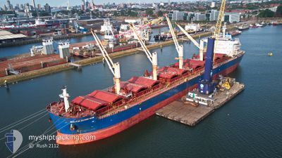
The vessel BALTIC SCORPION (IMO: 9729477, MMSI: 538005968) is a Cargo It's sailing under the flag of [MH] Marshall Is.
In this page you can find informations about the vessels current position, last detected port calls, and current voyage information. If the vessels is not in coverage by AIS you will find the latest position.
The current position of BALTIC SCORPION is detected by our AIS receivers and we are not responsible for the reliability of the data. The last position was recorded while the vessel was in Coverage by the Ais receivers of our vessel tracking app.
The current draught of BALTIC SCORPION as reported by AIS is 11.5 meters
Weather
| Temperature | 16.7°C / 62.06°F |
|---|---|
| Wind Speed | 19 knots |
| Direction | 348° NNW |
| Pressure | 1004.5 hPa |
| Humidity | 83.9 % |
| Cloud Coverage | 100 % |
Featured Company
Last Port Calls
| Port | Arrival | Departure | Time In Port |
|---|---|---|---|
| 2024-03-23 14:12 | 2024-04-08 14:01 | 15 d | |
| 2024-02-17 17:52 | 2024-03-01 01:42 | 12 d | |
| 2024-02-10 22:37 | 2024-02-16 02:39 | 5 d |
Most Visited Ports (Last year)
| Port | Arrivals | |
|---|---|---|
| 2 | ||
| 2 | ||
| 2 | ||
| 1 | ||
| 1 | ||
| 1 |
Last Trips
| Origin | Departure | Destination | Arrival | Distance | |
|---|---|---|---|---|---|
| 2024-03-01 01:42 | 2024-03-23 16:12 | 3155.29 nm | |||
| 2024-02-16 02:39 | 2024-02-17 17:52 | 36.81 nm | |||
| 2024-01-21 23:19 | 2024-02-10 22:37 | 4855.58 nm |
Events
| Tid | Event | Detaljer | Position / Dest | Information |
|---|---|---|---|---|
| 2024-04-22 01:20 | Status ändrad | Default Under way using engine |
35.98543 / 22.94566
GI GIB
|
Fart: 10.8 kn Kurs: 264.2° |
| 2024-04-22 01:16 | UTANFÖR täckningsområde |
35.98658 / 22.95903
Mediterranean Sea - Eastern Basin
GI GIB
|
Fart: 10.8 kn Kurs: 264.2° |
|
| 2024-04-22 01:01 | Byter havsområde | Greek part of the Mediterranean Sea - Eastern Basin Greek part of the Aegean Sea |
35.99316 / 23.01716
Mediterranean Sea - Eastern Basin
GI GIB
|
Fart: 10.7 kn Kurs: 257.6° |
| 2024-04-22 01:01 | Status ändrad | Under way using engine Default |
35.99316 / 23.01716
GI GIB
|
Fart: 10.6 kn Kurs: 258° |
| 2024-04-22 00:19 | Status ändrad | Default Under way using engine |
36.02778 / 23.16248
GI GIB
|
Fart: 10.7 kn Kurs: 242.4° |
| 2024-04-22 00:06 | Status ändrad | Under way using engine Default |
36.04438 / 23.20491
GI GIB
|
Fart: 10.7 kn Kurs: 246° |
| 2024-04-22 00:02 | I täckningsområde |
36.04438 / 23.20491
Aegean Sea
GI GIB
|
Fart: 10.8 kn Kurs: 248.4° |
|
| 2024-04-21 22:20 | Status ändrad | Default Under way using engine |
36.07883 / 23.58567
GI GIB
|
Fart: 10.6 kn Kurs: 266.9° |
| 2024-04-21 22:16 | Status ändrad | Under way using engine Default |
36.07938 / 23.59780
GI GIB
|
Fart: 10.4 kn Kurs: 267° |
| 2024-04-21 22:16 | UTANFÖR täckningsområde |
36.07938 / 23.59780
Aegean Sea
GI GIB
|
Fart: 10.6 kn Kurs: 266.9° |