
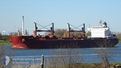
ASTORIA
Bulk Carrier
Current Trip
| Time Travelled | 18 h, 39 mins |
|---|---|
| Remaining Time | --- |
| Distance Travelled | 140.12 nm |
| Remaining Distance | --- |
| AVG Speed | 11.1 Knop |
| MAX Speed | 13 Knop |
| AVG Wind | 10 knots |
| MAX Wind | 13.8 knots |
| MIN Temp | 20.5°C / 68.9°F |
| MAX Temp | 25.5°C / 77.9°F |
| Djupgående | 7.6 m |
| Position mottagen | 4 h, 7 m sen |
Current Position
| Longitud | -78.67355° |
|---|---|
| Latitude | 32.76552° |
| Status | At anchor |
| Fart | |
| Kurs | 200° |
| Område | North Atlantic Ocean |
| Station | T-AIS |
| Position mottagen | 4 h, 7 m sen |
Info
Information
The current position of ASTORIA is in North Atlantic Ocean with coordinates 32.76552° / -78.67355° as reported on 2024-04-18 06:56 by AIS to our vessel tracker app. The vessel's current speed is 0 Knop and is heading at the port of WILMINGTON. The estimated time of arrival as calculated by MyShipTracking vessel tracking app is 2024-04-22 00:01 LT
The vessel ASTORIA (IMO: 9663635, MMSI: 636015672) is a Bulk Carrier that was built in 2013 ( 11 År gammal ). It's sailing under the flag of [LR] Liberia.
In this page you can find informations about the vessels current position, last detected port calls, and current voyage information. If the vessels is not in coverage by AIS you will find the latest position.
The current position of ASTORIA is detected by our AIS receivers and we are not responsible for the reliability of the data. The last position was recorded while the vessel was in Coverage by the Ais receivers of our vessel tracking app.
The current draught of ASTORIA as reported by AIS is 7.6 meters
Weather
| Temperature | 20.9°C / 69.62°F |
|---|---|
| Wind Speed | 9 knots |
| Direction | 250° WSW |
| Pressure | 1018.2 hPa |
| Humidity | 87.1 % |
| Cloud Coverage | 100 % |
Featured Company
Last Trips
| Origin | Departure | Destination | Arrival | Distance | |
|---|---|---|---|---|---|
| 2024-03-19 09:07 | 2024-04-11 18:19 | 4591.14 nm | |||
| 2024-01-12 17:39 | 2024-02-05 11:42 | 4974.03 nm |
Events
| Tid | Event | Detaljer | Position / Dest | Information |
|---|---|---|---|---|
| 2024-04-18 06:59 | Status ändrad | Default At anchor |
32.76500 / -78.67333
USILM WILMINGTON USA
|
Fart: Kurs: 200° |
| 2024-04-18 06:56 | Status ändrad | At anchor Default |
32.76552 / -78.67355
USILM WILMINGTON USA
|
Fart: Kurs: -1° |
| 2024-04-18 06:56 | UTANFÖR täckningsområde |
32.76552 / -78.67355
North Atlantic Ocean
USILM WILMINGTON USA
|
Fart: Kurs: 95.1° |
|
| 2024-04-18 06:34 | Status ändrad | Default At anchor |
32.76500 / -78.67333
USILM WILMINGTON USA
|
Fart: 0.1 kn Kurs: 202° |
| 2024-04-18 06:14 | Status ändrad | At anchor Default |
32.76567 / -78.67374
USILM WILMINGTON USA
|
Fart: Kurs: -1° |
| 2024-04-18 05:59 | Status ändrad | Default At anchor |
32.76562 / -78.67366
USILM WILMINGTON USA
|
Fart: Kurs: 197° |
| 2024-04-18 05:20 | Status ändrad | At anchor Default |
32.76566 / -78.67377
USILM WILMINGTON USA
|
Fart: Kurs: -1° |
| 2024-04-18 05:16 | Status ändrad | Default At anchor |
32.76500 / -78.67333
USILM WILMINGTON USA
|
Fart: 0.3 kn Kurs: 196° |
| 2024-04-18 04:23 | STOPPAR förflyttning |
32.76566 / -78.67412
USILM WILMINGTON USA
|
Fart: 0.1 kn Kurs: 200° |
|
| 2024-04-18 04:05 | Status ändrad | At anchor Under way using engine |
32.76300 / -78.67647
USILM WILMINGTON USA
|
Fart: 1.2 kn Kurs: 71° |