
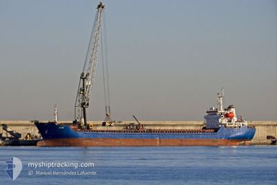
ALTAY
Bulk Carrier
Current Trip
| Time Travelled | 4 days |
|---|---|
| Remaining Time | --- |
| Distance Travelled | 294.30 nm |
| Remaining Distance | --- |
| AVG Speed | 7.8 Knop |
| MAX Speed | 10.1 Knop |
| AVG Wind | 12.7 knots |
| MAX Wind | 32.7 knots |
| MIN Temp | 4.6°C / 40.28°F |
| MAX Temp | 15°C / 59°F |
| Djupgående | 4.1 m |
| Position mottagen | 2 h, 30 m sen |
Current Position
| Longitud | 5.25807° |
|---|---|
| Latitude | 43.02958° |
| Status | Under way using engine |
| Fart | 7.5 Knop |
| Kurs | 273.7° |
| Område | Mediterranean Sea - Western Basin |
| Station | T-AIS |
| Position mottagen | 2 h, 30 m sen |
Info
Information
The current position of ALTAY is in Mediterranean Sea - Western Basin with coordinates 43.02958° / 5.25807° as reported on 2024-04-25 06:56 by AIS to our vessel tracker app. The vessel's current speed is 7.5 Knop and is heading at the port of TENES. The estimated time of arrival as calculated by MyShipTracking vessel tracking app is 2024-04-27 07:00 LT
The vessel ALTAY (IMO: 9349992, MMSI: 538004502) is a Bulk Carrier that was built in 2006 ( 18 År gammal ). It's sailing under the flag of [MH] Marshall Is.
In this page you can find informations about the vessels current position, last detected port calls, and current voyage information. If the vessels is not in coverage by AIS you will find the latest position.
The current position of ALTAY is detected by our AIS receivers and we are not responsible for the reliability of the data. The last position was recorded while the vessel was in Coverage by the Ais receivers of our vessel tracking app.
The current draught of ALTAY as reported by AIS is 4.1 meters
Weather
| Temperature | 11.1°C / 51.98°F |
|---|---|
| Wind Speed | 18 knots |
| Direction | 321° NW |
| Pressure | 1010.4 hPa |
| Humidity | 59 % |
| Cloud Coverage | 6 % |
Featured Company
Last Port Calls
| Port | Arrival | Departure | Time In Port |
|---|---|---|---|
| 2024-04-19 11:57 | 2024-04-20 23:46 | 1 d | |
| 2024-04-14 05:57 | 2024-04-16 02:20 | 1 d | |
| 2024-04-09 00:20 | 2024-04-09 11:16 | 10 h | |
| 2024-04-06 12:33 | 2024-04-08 12:01 | 1 d | |
| 2024-03-27 10:21 | 2024-03-29 06:46 | 1 d | |
| 2024-03-26 02:00 | |||
| 2024-03-18 14:46 | 2024-03-19 23:16 | 1 d | |
| 2024-03-14 17:04 | |||
| 2024-03-11 20:18 | |||
| 2024-02-29 13:15 | 2024-02-29 13:21 | 6 m |
Last Trips
| Origin | Departure | Destination | Arrival | Distance | |
|---|---|---|---|---|---|
| 2024-04-16 03:20 | 2024-04-19 13:57 | 505.75 nm | |||
| 2024-04-09 13:16 | 2024-04-14 06:57 | 465.89 nm | |||
| 2024-04-08 14:01 | 2024-04-09 02:20 | 110.56 nm | |||
| 2024-03-29 09:46 | 2024-04-06 14:33 | 1544.60 nm | |||
| 2024-03-26 04:00 | 2024-03-27 13:21 | 180.57 nm | |||
| 2024-03-11 23:18 | 2024-03-14 21:04 | 252.96 nm | |||
| 2024-02-28 15:45 | 2024-02-29 15:15 | 68.17 nm | |||
| 2024-02-21 06:59 | 2024-02-23 15:47 | 60.58 nm | |||
| 2024-02-15 12:03 | 2024-02-20 15:06 | 1035.29 nm | |||
| 2024-02-04 03:21 | 2024-02-12 17:57 | 546.16 nm |
Events
| Tid | Event | Detaljer | Position / Dest | Information |
|---|---|---|---|---|
| 2024-04-25 07:06 | Status ändrad | Default Under way using engine |
43.03106 / 5.23201
TENES
|
Fart: 7.5 kn Kurs: 273.7° |
| 2024-04-25 06:56 | UTANFÖR täckningsområde |
43.02958 / 5.25807
Mediterranean Sea - Western Basin
TENES
|
Fart: 7.5 kn Kurs: 273.7° |
|
| 2024-04-25 06:43 | Status ändrad | Under way using engine Default |
43.02640 / 5.29671
TENES
|
Fart: 6.9 kn Kurs: 275° |
| 2024-04-25 06:43 | I täckningsområde |
43.02663 / 5.29401
Mediterranean Sea - Western Basin
TENES
|
Fart: 7 kn Kurs: 277.8° |
|
| 2024-04-25 05:46 | Status ändrad | Default Under way using engine |
43.01392 / 5.44433
TENES
|
Fart: 6 kn Kurs: 276.9° |
| 2024-04-25 05:23 | Status ändrad | Under way using engine Default |
43.00898 / 5.49648
TENES
|
Fart: 5 kn Kurs: 278° |
| 2024-04-25 05:23 | UTANFÖR täckningsområde |
43.00898 / 5.49648
Mediterranean Sea - Western Basin
TENES
|
Fart: 6 kn Kurs: 276.9° |
|
| 2024-04-25 05:13 | Status ändrad | Default Under way using engine |
43.00667 / 5.52000
TENES
|
Fart: 6.3 kn Kurs: 282.6° |
| 2024-04-25 04:47 | Status ändrad | Under way using engine Default |
43.00033 / 5.58169
TENES
|
Fart: 6 kn Kurs: 277° |
| 2024-04-25 04:31 | Status ändrad | Default Under way using engine |
42.99500 / 5.61667
TENES
|
Fart: 6.1 kn Kurs: 280.6° |