
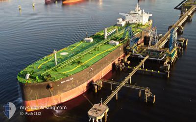
ALFA BALTICA
Tanker
Current Trip
DZAZW>LTBOT
| Time Travelled | 25 days |
|---|---|
| Remaining Time | --- |
| Distance Travelled | 2910.41 nm |
| Remaining Distance | --- |
| AVG Speed | 9.4 Knop |
| MAX Speed | 13.7 Knop |
| AVG Wind | 18.7 knots |
| MAX Wind | 37 knots |
| MIN Temp | 1.1°C / 33.98°F |
| MAX Temp | 27.6°C / 81.68°F |
| Djupgående | 12.7 m |
| Position mottagen | 23 m sen |
Current Position
| Longitud | 16.97376° |
|---|---|
| Latitude | 55.87517° |
| Status | Under way using engine |
| Fart | 7.4 Knop |
| Kurs | 255.1° |
| Område | Baltic Sea |
| Station | T-AIS |
| Position mottagen | 23 m sen |
Info
Information
The current position of ALFA BALTICA is in Baltic Sea with coordinates 55.87517° / 16.97376° as reported on 2024-04-19 02:03 by AIS to our vessel tracker app. The vessel's current speed is 7.4 Knop
The vessel ALFA BALTICA (IMO: 9696773, MMSI: 311000306) is a Tanker It's sailing under the flag of [BS] Bahamas.
In this page you can find informations about the vessels current position, last detected port calls, and current voyage information. If the vessels is not in coverage by AIS you will find the latest position.
The current position of ALFA BALTICA is detected by our AIS receivers and we are not responsible for the reliability of the data. The last position was recorded while the vessel was in Coverage by the Ais receivers of our vessel tracking app.
The current draught of ALFA BALTICA as reported by AIS is 12.7 meters
Weather
| Temperature | 3.7°C / 38.66°F |
|---|---|
| Wind Speed | 4 knots |
| Direction | 135° SE |
| Pressure | 1007.7 hPa |
| Humidity | 86.2 % |
| Cloud Coverage | 83 % |
Featured Company
Events
| Tid | Event | Detaljer | Position / Dest | Information |
|---|---|---|---|---|
| 2024-04-19 01:21 | Byter havsområde | Swedish part of the Baltic Sea Lithuanian part of the Baltic Sea |
55.89952 / 17.12055
Baltic Sea
|
Fart: 7.2 kn Kurs: 253.7° |
| 2024-04-19 01:21 | I täckningsområde |
55.89952 / 17.12055
Baltic Sea
|
Fart: 7.2 kn Kurs: 253.7° |
|
| 2024-04-17 03:08 | STOPPAR förflyttning |
56.04415 / 20.95792
DZAZW>LTBOT
|
Fart: 0.2 kn Kurs: 26° |
|
| 2024-04-17 00:16 | STARTAR förflyttning | 21.16 nm, North West of KLAIPEDA |
55.93821 / 20.68771
DZAZW>LTBOT
|
Fart: 4 kn Kurs: 48° |
| 2024-04-16 21:23 | Status ändrad | Default Under way using engine |
55.94764 / 20.72673
DZAZW>LTBOT
|
Fart: 0.8 kn Kurs: 308° |
| 2024-04-16 21:16 | UTANFÖR täckningsområde |
55.94815 / 20.72872
Baltic Sea
|
Fart: 0.8 kn Kurs: 248.1° |
|
| 2024-04-16 21:15 | Status ändrad | Under way using engine Default |
55.94832 / 20.72960
DZAZW>LTBOT
|
Fart: 0.7 kn Kurs: 308° |
| 2024-04-16 21:03 | Status ändrad | Default Under way using engine |
55.94929 / 20.73364
DZAZW>LTBOT
|
Fart: 0.7 kn Kurs: 309° |
| 2024-04-16 20:47 | Status ändrad | Under way using engine Default |
55.95074 / 20.73920
DZAZW>LTBOT
|
Fart: 0.9 kn Kurs: 300° |
| 2024-04-16 20:32 | Status ändrad | Default Under way using engine |
55.95246 / 20.74432
DZAZW>LTBOT
|
Fart: 0.7 kn Kurs: 288° |