
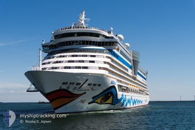
AIDADIVA
Passengers Ship
Current Trip
| Time Travelled | 10 h, 22 mins |
|---|---|
| Remaining Time | 4 h, 0 mins |
| Distance Travelled | 181.92 nm |
| Remaining Distance | 59.29 nm |
| AVG Speed | 17.2 Knop |
| MAX Speed | 19.7 Knop |
| AVG Wind | 10.3 knots |
| MAX Wind | 14.8 knots |
| MIN Temp | 4.7°C / 40.46°F |
| MAX Temp | 6°C / 42.8°F |
| Djupgående | 7.3 m |
| Position mottagen | 1 m sen |
Current Position
| Longitud | 11.64202° |
|---|---|
| Latitude | 56.53471° |
| Status | Under way using engine |
| Fart | 14.2 Knop |
| Kurs | 214.6° |
| Område | Kattegat |
| Station | T-AIS |
| Position mottagen | 1 m sen |
Info
Information
The current position of AIDADIVA is in Kattegat with coordinates 56.53471° / 11.64202° as reported on 2024-04-19 01:25 by AIS to our vessel tracker app. The vessel's current speed is 14.2 Knop and is heading at the port of AARHUS. The estimated time of arrival as calculated by MyShipTracking vessel tracking app is 2024-04-19 05:26 LT
The vessel AIDADIVA (IMO: 9334856, MMSI: 247187700) is a Passengers Ship that was built in 2007 ( 17 År gammal ). It's sailing under the flag of [IT] Italy.
In this page you can find informations about the vessels current position, last detected port calls, and current voyage information. If the vessels is not in coverage by AIS you will find the latest position.
The current position of AIDADIVA is detected by our AIS receivers and we are not responsible for the reliability of the data. The last position was recorded while the vessel was in Coverage by the Ais receivers of our vessel tracking app.
The current draught of AIDADIVA as reported by AIS is 7.3 meters
Weather
| Temperature | 5.1°C / 41.18°F |
|---|---|
| Wind Speed | 8 knots |
| Direction | 135° SE |
| Pressure | 1007.4 hPa |
| Humidity | 64.9 % |
| Cloud Coverage | 100 % |
Featured Company
Last Port Calls
| Port | Arrival | Departure | Time In Port |
|---|---|---|---|
| 2024-04-18 04:34 | 2024-04-18 15:04 | 10 h | |
| 2024-04-16 06:22 | 2024-04-16 19:01 | 12 h | |
| 2024-04-13 22:12 | 2024-04-14 15:06 | 16 h | |
| 2024-04-12 03:55 | 2024-04-12 18:02 | 14 h | |
| 2024-04-10 05:21 | 2024-04-10 15:23 | 10 h | |
| 2024-04-09 07:51 | 2024-04-09 19:12 | 11 h | |
| 2024-04-07 02:55 | 2024-04-07 18:24 | 15 h | |
| 2024-04-05 04:15 | 2024-04-05 17:05 | 12 h | |
| 2024-04-03 05:24 | 2024-04-03 15:35 | 10 h | |
| 2024-04-01 19:37 | 2024-04-02 19:10 | 23 h |
Last Trips
| Origin | Departure | Destination | Arrival | Distance | |
|---|---|---|---|---|---|
| 2024-04-16 20:01 | 2024-04-18 06:34 | 466.88 nm | |||
| 2024-04-14 17:06 | 2024-04-16 07:22 | 432.98 nm | |||
| 2024-04-12 20:02 | 2024-04-14 00:12 | 440.95 nm | |||
| 2024-04-10 16:23 | 2024-04-12 05:55 | 561.58 nm | |||
| 2024-04-09 20:12 | 2024-04-10 06:21 | 130.09 nm | |||
| 2024-04-07 19:24 | 2024-04-09 08:51 | 345.90 nm | |||
| 2024-04-05 19:05 | 2024-04-07 03:55 | 422.99 nm | |||
| 2024-04-03 16:35 | 2024-04-05 06:15 | 557.52 nm | |||
| 2024-04-02 20:10 | 2024-04-03 06:24 | 130.43 nm | |||
| 2024-03-31 19:20 | 2024-04-01 20:37 | 343.94 nm |
Events
| Tid | Event | Detaljer | Position / Dest | Information |
|---|---|---|---|---|
| 2024-04-18 22:17 | Byter havsområde | Danish part of the Kattegat Swedish part of the Kattegat |
57.32061 / 11.49950
Kattegat
DK AAR
|
Fart: 17.8 kn Kurs: 161.7° |
| 2024-04-18 21:38 | Byter havsområde | Swedish part of the Kattegat Danish part of the Kattegat |
57.49415 / 11.35966
Kattegat
DK AAR
|
Fart: 17.7 kn Kurs: 128.8° |
| 2024-04-18 20:20 | Byter havsområde | Danish part of the Kattegat Danish part of the Skaggerak |
57.78253 / 10.86712
Kattegat
DK AAR
|
Fart: 18.6 kn Kurs: 136.3° |
| 2024-04-18 17:23 | Byter havsområde | Danish part of the Skaggerak Norwegian part of the Skaggerak |
57.83005 / 9.13374
Skaggerak
DK AAR
|
Fart: 19.2 kn Kurs: 105.2° |
| 2024-04-18 15:04 | AVGÅTT HAMN |
|
58.12280 / 8.01601
DK AAR
|
Fart: 11.2 kn Kurs: 143° |
| 2024-04-18 14:54 | STARTAR förflyttning |
58.13597 / 7.98954
[NO] KRISTIANSAND
|
Fart: 3.2 kn Kurs: 175° |
|
| 2024-04-18 14:46 | Status ändrad | Under way using engine Moored |
58.13858 / 7.99243
[NO] KRISTIANSAND
|
Fart: Kurs: 114° |
| 2024-04-18 13:40 | Destination ändrad | DK AAR NOKRS |
58.13859 / 7.99243
[NO] KRISTIANSAND
|
Fart: Kurs: 114° |
| 2024-04-18 13:40 | ETA ändrat | 2024/04/19 06:00 2024/04/18 04:00 |
58.13859 / 7.99243
[NO] KRISTIANSAND
|
Fart: Kurs: 114° |
| 2024-04-18 05:03 | Status ändrad | Moored Under way using engine |
58.13860 / 7.99223
[NO] KRISTIANSAND
|
Fart: 0.2 kn Kurs: 115° |