
TIANJIN HIGHWAY
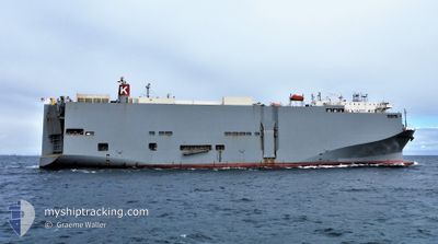
Vehicles Carrier
Current Trip
| Time Travelled | 7 days |
|---|---|
| Remaining Time | 1 day |
| Distance Travelled | 3025.38 морская миля |
| Remaining Distance | 628.80 морская миля |
| AVG Speed | 15.8 Узлы |
| MAX Speed | 19.1 Узлы |
| AVG Wind | 9.3 knots |
| MAX Wind | 25.8 knots |
| MIN Temp | 15.5°C / 59.9°F |
| MAX Temp | 29.9°C / 85.82°F |
| Осадка | 9 м |
| Позиция Получена | 7 d тому назад |
Current Position
| Долгота | 134.92998° |
|---|---|
| Широта | 33.95213° |
| Статус | Under way using engine |
| Скорость | 15.9 Узлы |
| Курс | 191° |
| Район | Philippine Sea |
| Станция | T-AIS |
| Позиция Получена | 7 d тому назад |
Info
Information
The current position of TIANJIN HIGHWAY is in Philippine Sea with coordinates 33.95213° / 134.92998° as reported on 2024-04-11 10:14 by AIS to our vessel tracker app. The vessel's current speed is 15.9 Узлы and is heading at the port of TOWNSVILLE. The estimated time of arrival as calculated by MyShipTracking vessel tracking app is 2024-04-20 14:15 LT
The vessel TIANJIN HIGHWAY (IMO: 9294355, MMSI: 371559000) is a Vehicles Carrier that was built in 2005 ( 19 лет ). It's sailing under the flag of [PA] Panama.
In this page you can find informations about the vessels current position, last detected port calls, and current voyage information. If the vessels is not in coverage by AIS you will find the latest position.
The current position of TIANJIN HIGHWAY is detected by our AIS receivers and we are not responsible for the reliability of the data. The last position was recorded while the vessel was in Coverage by the Ais receivers of our vessel tracking app.
The current draught of TIANJIN HIGHWAY as reported by AIS is 9 meters
Weather
| Temperature | 28°C / 82.4°F |
|---|---|
| Wind Speed | 6 knots |
| Direction | 340° NNW |
| Pressure | 1009.1 hPa |
| Humidity | 81 % |
| Cloud Coverage | 50 % |
Featured Company
Last Port Calls
| Port | Arrival | Departure | Time In Port |
|---|---|---|---|
| 2024-04-10 23:54 | 2024-04-11 06:46 | 6 h | |
| 2024-04-08 22:04 | 2024-04-09 08:24 | 10 h | |
| 2024-04-07 22:00 | 2024-04-08 05:33 | 7 h | |
| 2024-04-04 21:22 | 2024-04-06 03:57 | 1 d | |
| 2024-03-22 21:16 | 2024-03-23 06:21 | 9 h | |
| 2024-03-17 03:23 | 2024-03-19 02:43 | 1 d | |
| 2024-03-01 20:19 | 2024-03-03 00:47 | 1 d | |
| 2024-02-27 21:29 | 2024-02-28 10:16 | 12 h |
Last Trips
| Origin | Departure | Destination | Arrival | Distance | |
|---|---|---|---|---|---|
| 2024-04-09 17:24 | 2024-04-11 08:54 | 397.57 морская миля | |||
| 2024-04-08 14:33 | 2024-04-09 07:04 | 241.00 морская миля | |||
| 2024-04-06 12:57 | 2024-04-08 07:00 | 44.15 морская миля | |||
| 2024-03-22 23:21 | 2024-04-05 06:22 | 5324.46 морская миля | |||
| 2024-03-18 19:43 | 2024-03-22 14:16 | 909.93 морская миля | |||
| 2024-03-03 09:47 | 2024-03-16 20:23 | 5677.82 морская миля | |||
| 2024-02-28 19:16 | 2024-03-02 05:19 | 588.87 морская миля | |||
| 2024-01-30 17:04 | 2024-02-28 06:29 | 11046.42 морская миля |
Events
| Время | Событие | Детали | Позиция / Направление | Информация |
|---|---|---|---|---|
| 2024-04-11 10:18 | Статус изменился | Default Under way using engine |
33.93770 / 134.92656
AU TSV
|
Скорость: 15.9 kn Курс: 191° |
| 2024-04-11 10:14 | Вне покрытия |
33.95213 / 134.92998
Philippine Sea
AU TSV
|
Скорость: 15.9 kn Курс: 191° |
|
| 2024-04-11 10:13 | Статус изменился | Under way using engine Default |
33.95948 / 134.93172
AU TSV
|
Скорость: 16.1 kn Курс: 186° |
| 2024-04-11 09:41 | Статус изменился | Default Under way using engine |
34.09800 / 134.93536
AU TSV
|
Скорость: 16 kn Курс: 185° |
| 2024-04-11 09:36 | Статус изменился | Under way using engine Default |
34.12082 / 134.93793
AU TSV
|
Скорость: 15.8 kn Курс: 185° |
| 2024-04-11 09:34 | Статус изменился | Default Under way using engine |
34.13203 / 134.93919
AU TSV
|
Скорость: 14.7 kn Курс: 186° |
| 2024-04-11 08:50 | Изменение морского района | Japanese part of the Philippine Sea Japanese part of the Inland Sea |
34.26925 / 134.97172
Philippine Sea
AU TSV
|
Скорость: 14 kn Курс: 189° |
| 2024-04-11 06:46 | ПОРТ ОТПРАВЛЕНИЯ |
|
34.66095 / 135.30762
AU TSV
|
Скорость: 10.9 kn Курс: 176° |
| 2024-04-11 06:27 | Начало движения |
34.69918 / 135.28288
[JP] KOBE
|
Скорость: 3.9 kn Курс: 90° |
|
| 2024-04-11 06:13 | Статус изменился | Under way using engine Moored |
34.69810 / 135.27995
[JP] KOBE
|
Скорость: Курс: 99° |